Colorado’s oil and gas wells are on public record with the Energy and Carbon Management Commission (ECMC, formerly COGCC) and CDPHE [1]. The state portal lists those wells, but their emissions and enforcement records sit in separate systems, and it offers no peer comparison [1]. Assembling one site’s full picture means reconciling production, gas composition, emissions, and enforcement across those portals by hand. TetraSoft Atlas is our subscription platform whose interactive Colorado oil and gas map connects every well and facility to its full record [2]. Each record comes from ECMC and CDPHE and is refreshed monthly, so a search returns current data [2].
Quick Answer: Colorado has about 41,000 oil and gas wells and 10,700 facilities operated by 254 companies on ECMC and CDPHE record. Atlas maps them on one screen, cross-linked with production, emissions, enforcement, and peer benchmarks, refreshed monthly [2].
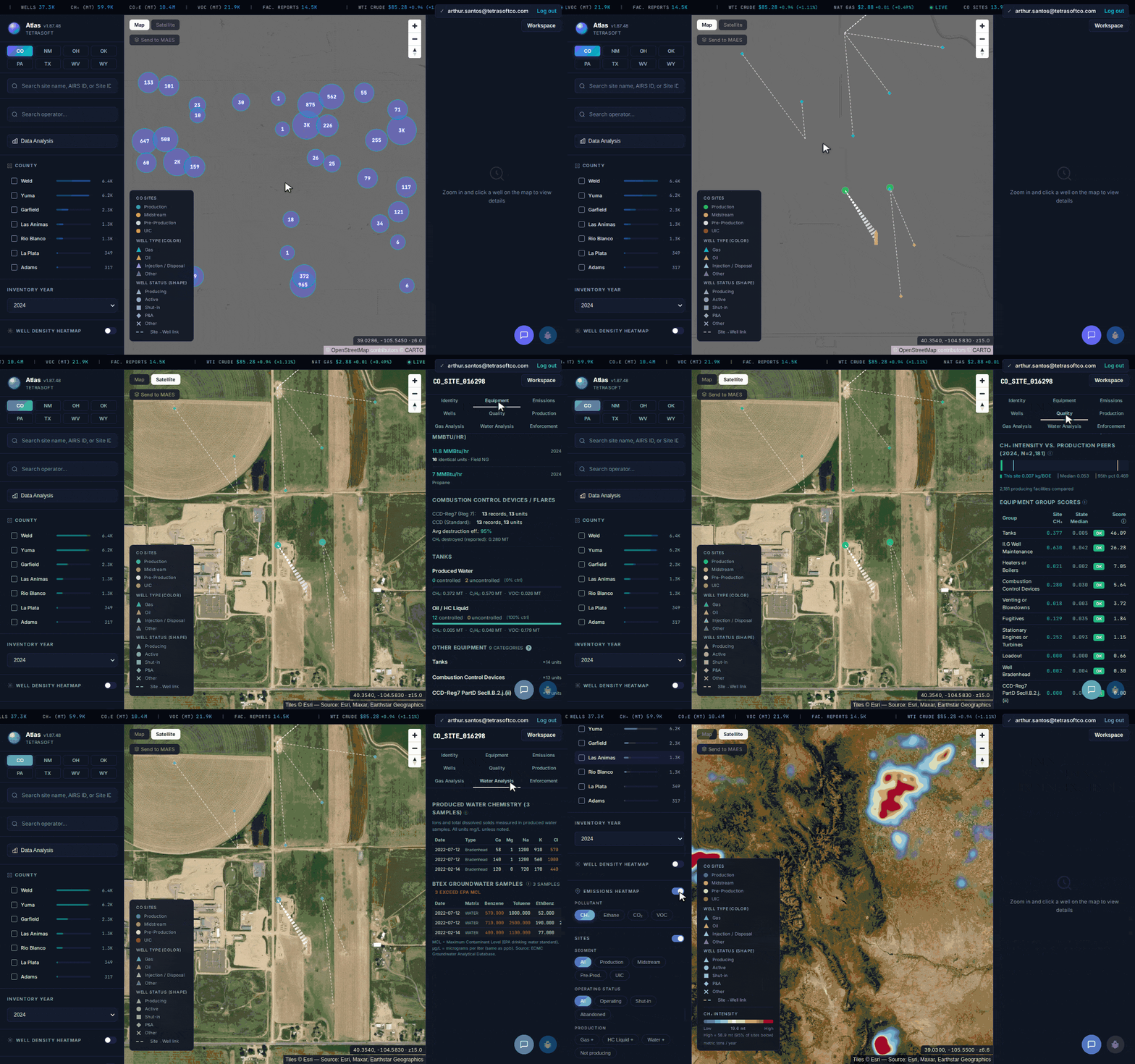
Every Colorado well and facility on one map, with statewide methane, CO₂e, and VOC totals built in. [2]
Search Every Colorado Oil & Gas Well and Open Its Full Record
For a Colorado oil and gas well search, TetraSoft Atlas returns any well from a single search box [2]. You search by API number, well name, or operator, without paging through separate portals [2]. Every result opens the site with its full record attached [2].
Colorado oil and gas production data sits next to emissions on the same screen [2]. Annual and monthly volumes line up against the emissions the state map leaves out [2].
Enforcement history is tied to each facility too [2]. Alleged violations sit next to EPA ECHO evaluations and formal actions [3]. You can also match groundwater and water-chemistry records against emissions flags [2]. Those are links a single-source portal cannot make.
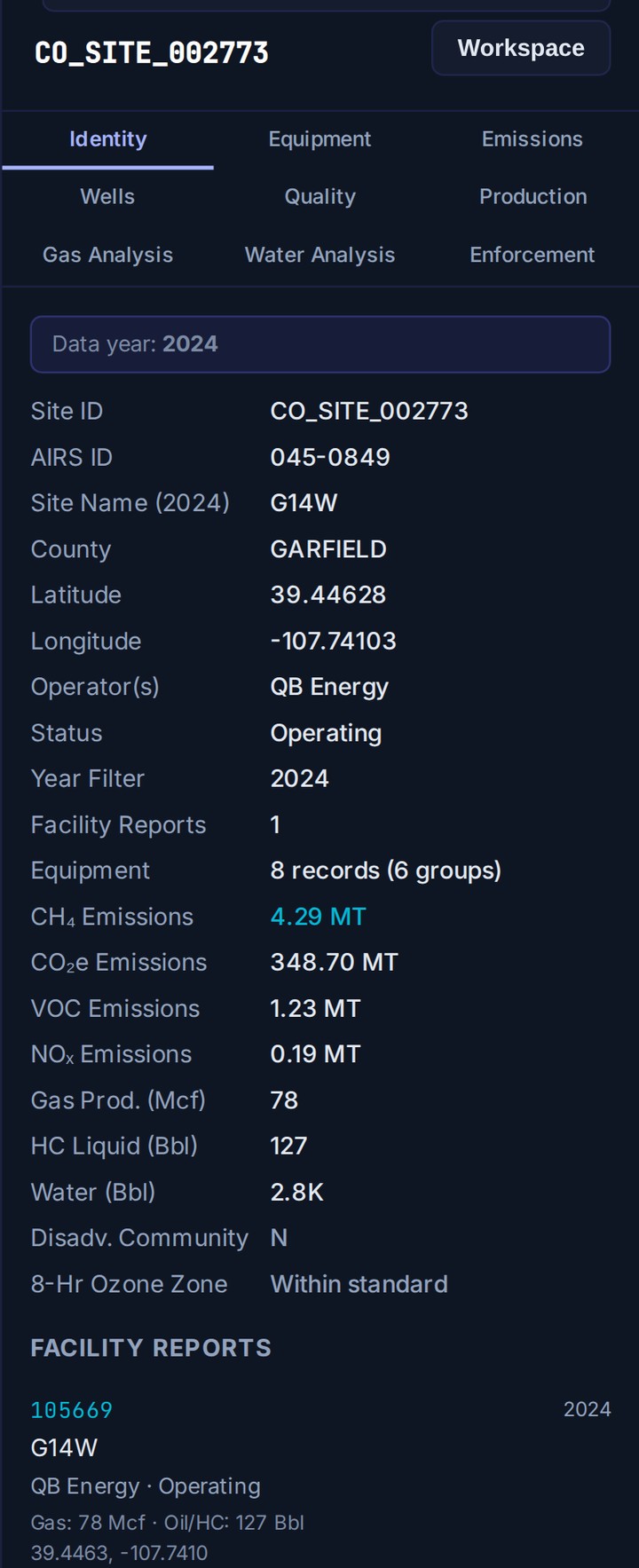
One facility’s full record in Atlas: production, emissions, equipment, and reports, cross-linked in a single panel. [2]
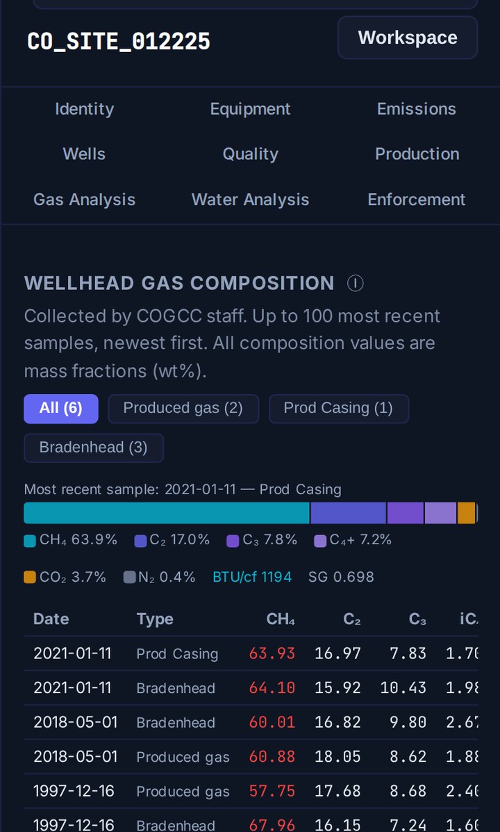
Every wellhead gas sample for a site, by date, with methane, ethane, propane, CO₂, and BTU. [2]
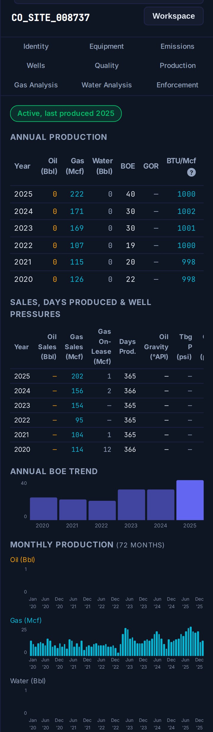
A site’s full production history: annual and monthly oil, gas, and water, with a BOE trend. [2]
See How Any Operator Ranks Against Its Colorado Peers
Atlas ranks each facility against comparable Colorado sites and shows the percentile [2]. Peer context is what turns a raw emissions number into a decision. Now you can say a site sits in the top ten percent of methane among its peers [2].
Atlas also flags sites whose reported data looks anomalous [2]. Anomalous here means out of step with peers reporting similar operations in the same year [2]. Some sites carry heavy anomalies with no enforcement on record [2].
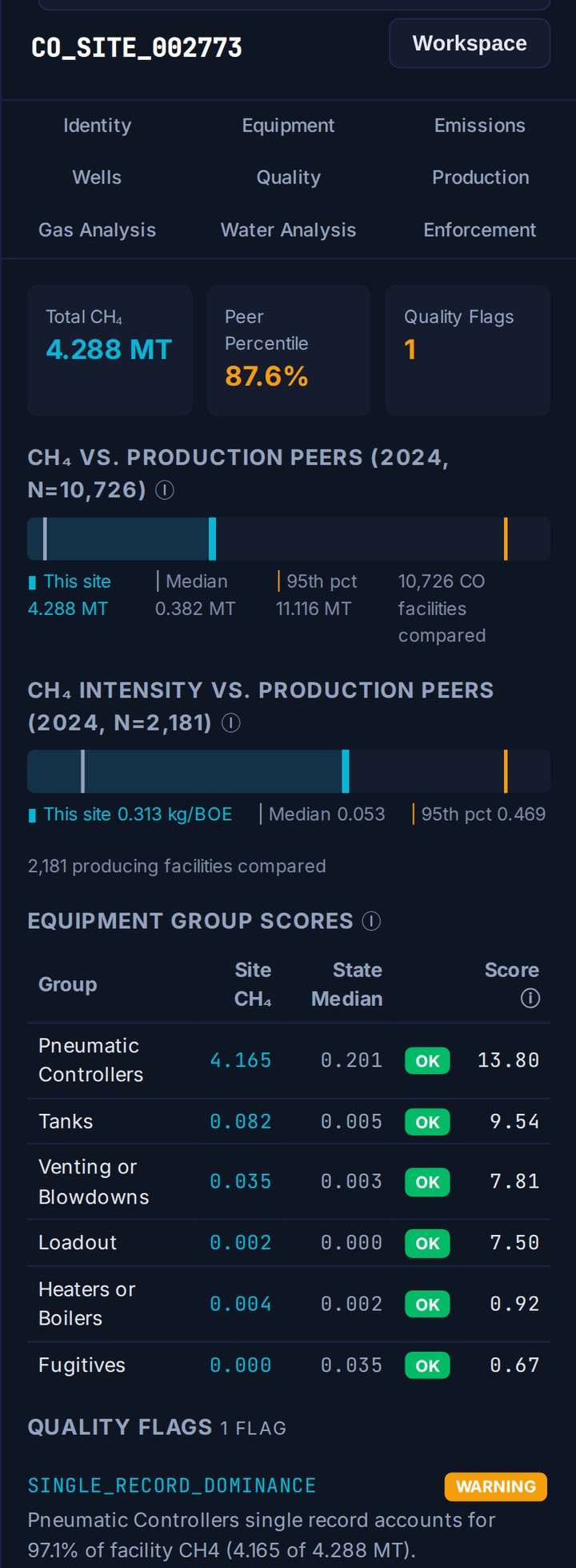
Atlas ranks each facility against its Colorado peers on methane. This site sits in the 87.6th percentile of 10,726 production peers.
TetraSoft Atlas Connects the Colorado Oil & Gas Data the State Portal Keeps Apart
TetraSoft Atlas pulls Colorado wells, emissions, and enforcement into one connected view [2]. Without it, managing sites means chasing data in pieces. The wells sit in one portal, emissions in another, and enforcement somewhere else [1]. None of those systems talk to each other.
Colorado is one of the eight states in TetraSoft Atlas, which together produced 68 percent of US crude oil and 83 percent of US marketed natural gas in 2025 [4]. Atlas is self-serve, with no sales call: you sign up and start a 7-day trial with no credit card [2].
So you export three spreadsheets and match them by hand. Even then, one question stays hard: which of my sites would a reviewer flag first? Catching that before it reaches an agency review is easier and less costly than correcting it afterward.
The State Portal Cannot Show Emissions, Enforcement, or Peer Rank
The state portal shows records one at a time; Atlas connects them in one view.
| Capability | The state portal | Atlas |
|---|---|---|
| Well, facility, and operator records | Separate lookups | Cross-linked in one view |
| Emissions per site | Not shown | Shown |
| Enforcement history per site | Scattered | Tied to the facility |
| Peer benchmarking | Not available | Methane percentile versus peers |
| Multiple states | Colorado only | Eight states, one view |
| Time to an answer | Hours | Seconds |
| Official filing and system of record | Where operators file, and where the authoritative record lives | Maps the published data, not the system of record |
The comparison reflects the state portal’s publicly observable limitations and rough time-to-answer estimates, checked against the live ECMC and CDPHE portals in July 2026 [1]. Every row above ships for Colorado today [2]. The difference is not more data; the difference is connected data. One thing the portal still owns is the system of record: operators file there and the authoritative document lives there, so for an official filing you use ECMC and CDPHE, not Atlas.
TetraSoft Atlas Draws Colorado Oil & Gas Data From ECMC and CDPHE, Refreshed Monthly
TetraSoft Atlas draws every Colorado record from ECMC and CDPHE, refreshes it monthly, and lets you reach any site in three steps [2]. First, start a free trial that runs for seven days [2]. Second, search your operator, your county, or a single API number [2].
Third, read the well’s output, emissions, enforcement, and peer standing on one screen [2]. The work that took days takes a search box.
The Data Comes From ECMC and CDPHE, and Spans Eight States
Atlas carries public records from ECMC (formerly COGCC) and CDPHE [1]. Atlas does not invent numbers; the map connects the records the agencies already publish, including operators’ annual ONGAEIR emissions filings. Atlas refreshes the Colorado data monthly and defaults to the latest reporting year [2]. You review the same current records the agency uses. Orphaned and abandoned wells are a separate category, mapped starting with New Mexico in the abandoned gas wells guide.
Colorado is one of eight states in Atlas today [2]. You can open the same view for Texas, New Mexico, Oklahoma, Wyoming, West Virginia, Pennsylvania, and Ohio [2]. That is the coverage today, and TetraSoft is actively adding more states over time. Each state links back to this Colorado map, and neighboring basins cross-link [2].
See the Whole State at Once, Not Just One Site
Beyond the per-site record, Atlas includes a statewide Data Analytics view for Colorado [2]. It ranks operators by emissions, flags sites whose reporting looks anomalous, summarizes compliance and enforcement, and charts gas composition across the state [2]. You move from a single well to the full Colorado picture without leaving the map. For how the state scores methane intensity, see Colorado’s verification factor.
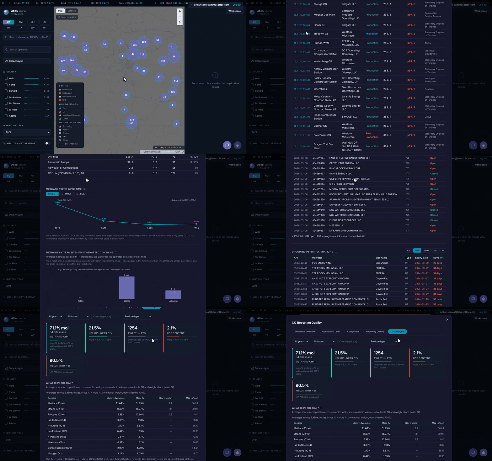
Atlas Data Analytics for Colorado: emissions overview, operational detail, compliance, reporting quality, and gas-composition tabs, statewide. [2]
Frequently Asked Questions
Is COGCC now ECMC?
Yes. The Colorado Oil and Gas Conservation Commission (COGCC) was renamed the Energy and Carbon Management Commission (ECMC) [1]. The mandate expanded, but the underlying well and permit records carried over [1]. Atlas maps both the current ECMC data and the legacy COGCC records, cross-linked [2].
How current is the Colorado data in TetraSoft Atlas?
Atlas refreshes the Colorado data every month [2]. The map defaults to the latest reporting year, so a search returns current records instead of a stale snapshot [2]. Older reporting years stay available when you compare a site over time [2].
What counts as a well or facility on the map?
Atlas maps about 41,000 wells and 10,700 facilities operated by 254 distinct companies across reporting years 2021 to 2024. A facility groups the wells and equipment reported together, and each one carries its own production and emissions [2]. Enforcement history attaches at the facility level [2].
Can I see enforcement history for a specific site?
Each facility separates state-level alleged violations from federal EPA ECHO inspections and formal actions, each carrying its own dates [3]. ECHO adds the federal compliance and inspection history that the state well portal does not carry [3]. So you get both the state and federal enforcement view for a site in one record.
How much does TetraSoft Atlas cost?
Atlas is priced by team size, billed monthly or annually [2]. Pricing scales by the number of users on your team, not by the volume of data you pull [2]. For current rates, see the Atlas pricing page [2]. Every plan starts with a seven-day free trial, and you can cancel anytime [2].
A well’s output, its emissions, its enforcement record, and its peer standing belong on one Colorado map, sourced from ECMC and CDPHE and refreshed monthly. Atlas puts them there, and a search returns any operator’s sites in seconds [2]. Start your free 7-day trial.
This post is for informational purposes only and does not constitute legal or compliance advice. Consult qualified legal counsel or a compliance professional for guidance specific to your operations and jurisdiction.
References
- Colorado Energy and Carbon Management Commission (ECMC, formerly COGCC) and Colorado Department of Public Health and Environment (CDPHE) public oil and gas records.
- TetraSoft Atlas, Colorado oil and gas dataset and product features. https://tetrasoftco.com/atlas-landing.html#pricing
- U.S. Environmental Protection Agency, Enforcement and Compliance History Online (ECHO).
- U.S. Energy Information Administration, crude oil field production and natural gas marketed production by state, annual 2025, accessed 23 September 2026. https://www.eia.gov/dnav/pet/pet_crd_crpdn_adc_mbbl_a.htm; https://www.eia.gov/dnav/ng/ng_prod_sum_a_EPG0_VGM_mmcf_a.htm
Comments
0Share your thoughts. All comments are moderated before appearing.
No comments yet. Be the first to share your thoughts!