Oklahoma has about 456,000 oil and gas wells on record across all 77 counties, tracked by the Oklahoma Corporation Commission (OCC). An OCC well search means moving between the Well Data Finder, the OCC RBDMS Data Explorer, and the imaging system, each a separate lookup [1]. None of those tools connects a well’s identity to its records and wellhead gas composition in one view. TetraSoft Atlas, a subscription data platform, draws those OCC records into one interactive Oklahoma oil and gas map of every well [2]. You can find any well and open its full record, with its wellhead gas composition, in seconds [2].
Quick Answer: Oklahoma has about 456,000 oil and gas wells across all 77 counties on OCC record. Atlas maps them on one screen and adds wellhead gas composition from USGS and a statewide analysis view [2]. An Oklahoma oil well search in Atlas finds any well by well name or operator, filtered by county if you need it [2].
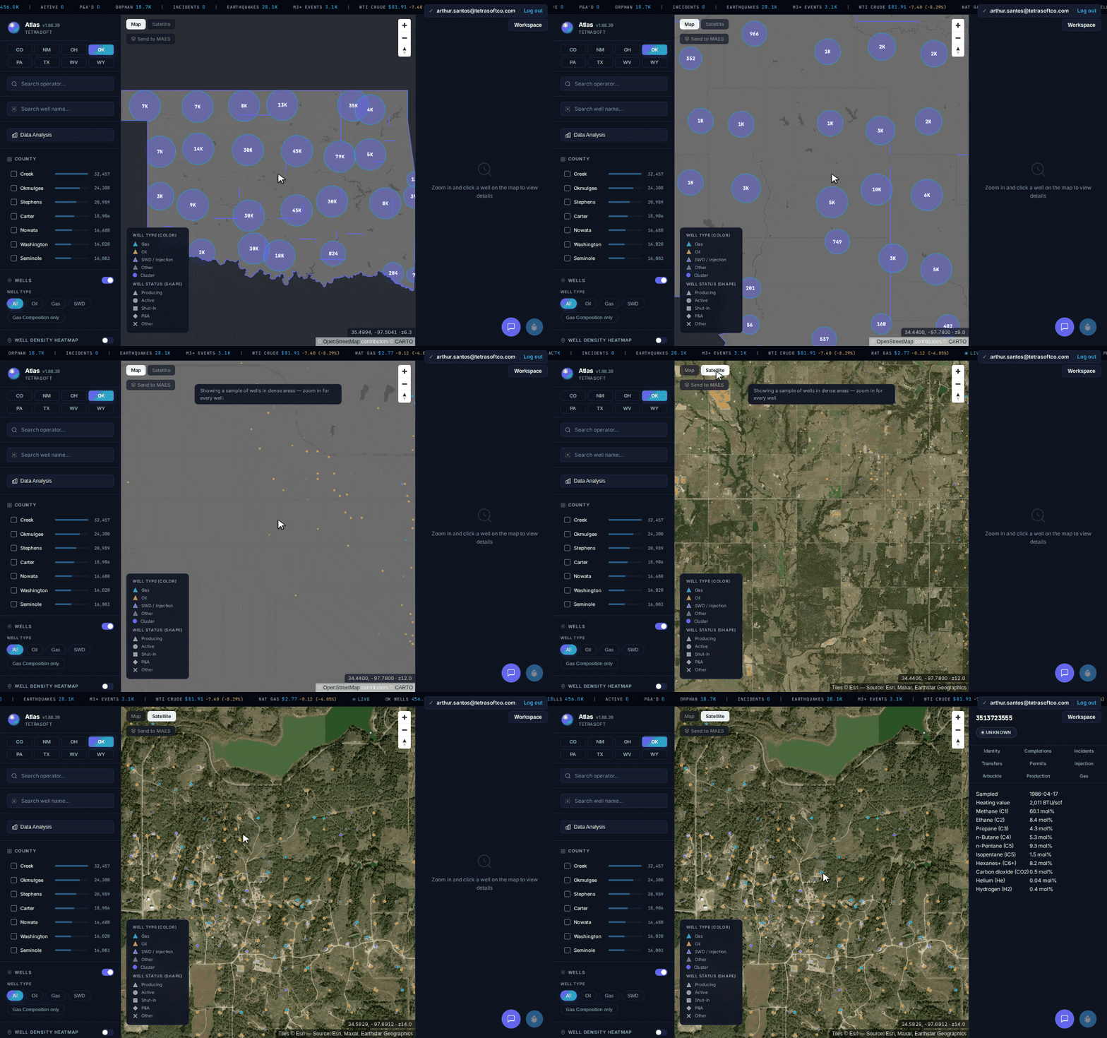
Every Oklahoma well on one map, in map or satellite view, from statewide clusters down to a single well’s full record. [2]
Search Every Oklahoma Well and Open Its Full Record
For an Oklahoma oil and gas well search, TetraSoft Atlas returns any well from a single search box [2]. You search by well name or operator, or filter by county, without paging through separate OCC systems [2]. The map clusters wells statewide, then resolves to individual wells as you zoom in [2].
Creek and Okmulgee counties hold the densest well cover, the old Cushing and Glenn Pool producing belt. Zoom into that core and each triangle is one well, colored by type [2]. Teal marks gas wells; orange marks oil [2]. Switch the basemap to satellite, and the same wells sit over aerial imagery of the pads on the ground [2].
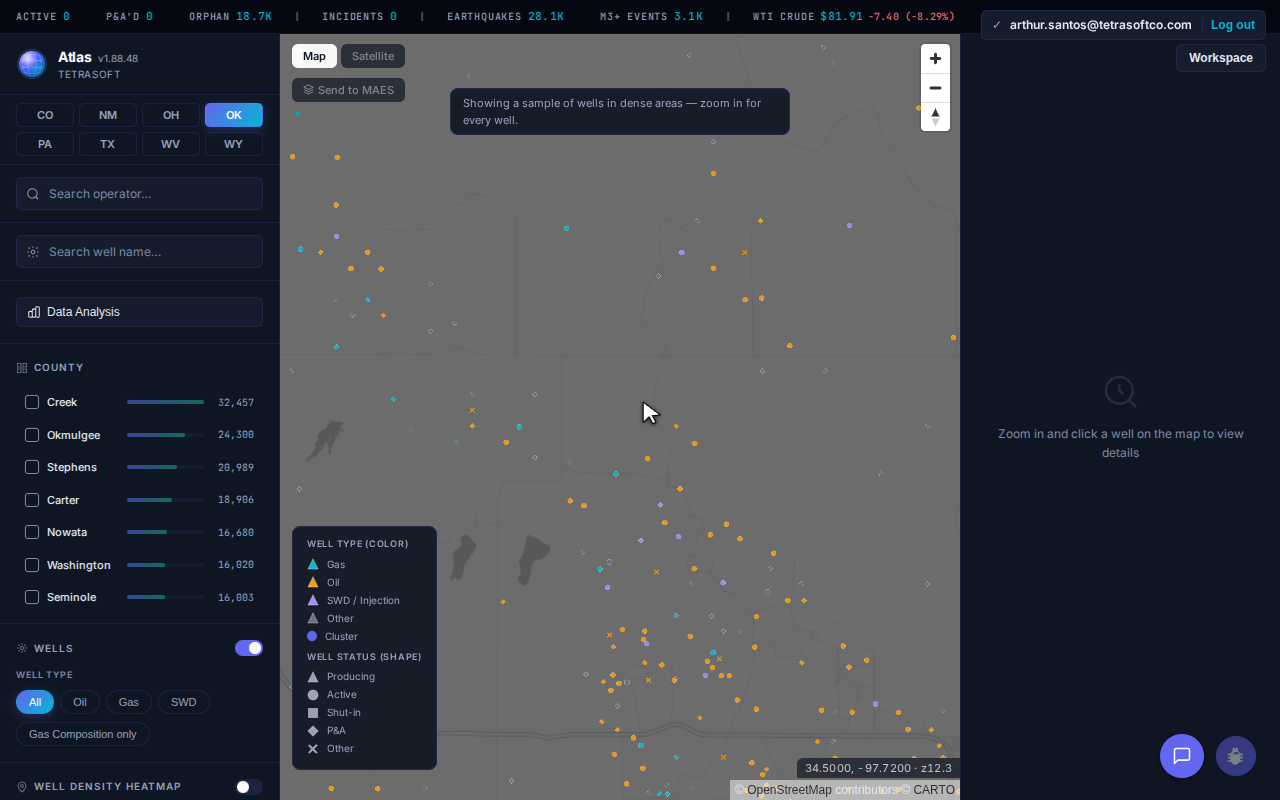
The Oklahoma well map, clustered by count; individual wells resolve as you zoom in. [2]
Click a well and its full record opens beside the map, in tabs you step through [2].
Read the Wellhead Gas Composition for a Well
Each well’s gas tab lists the mole fractions from its most recent lab sample [3]. The panel shows methane and the heavier hydrocarbons, plus carbon dioxide and any trace gases in the sample [3]. The heating value in BTU sits at the top of the same panel [3]. That composition separates a lean gas well from a rich, NGL-heavy one.
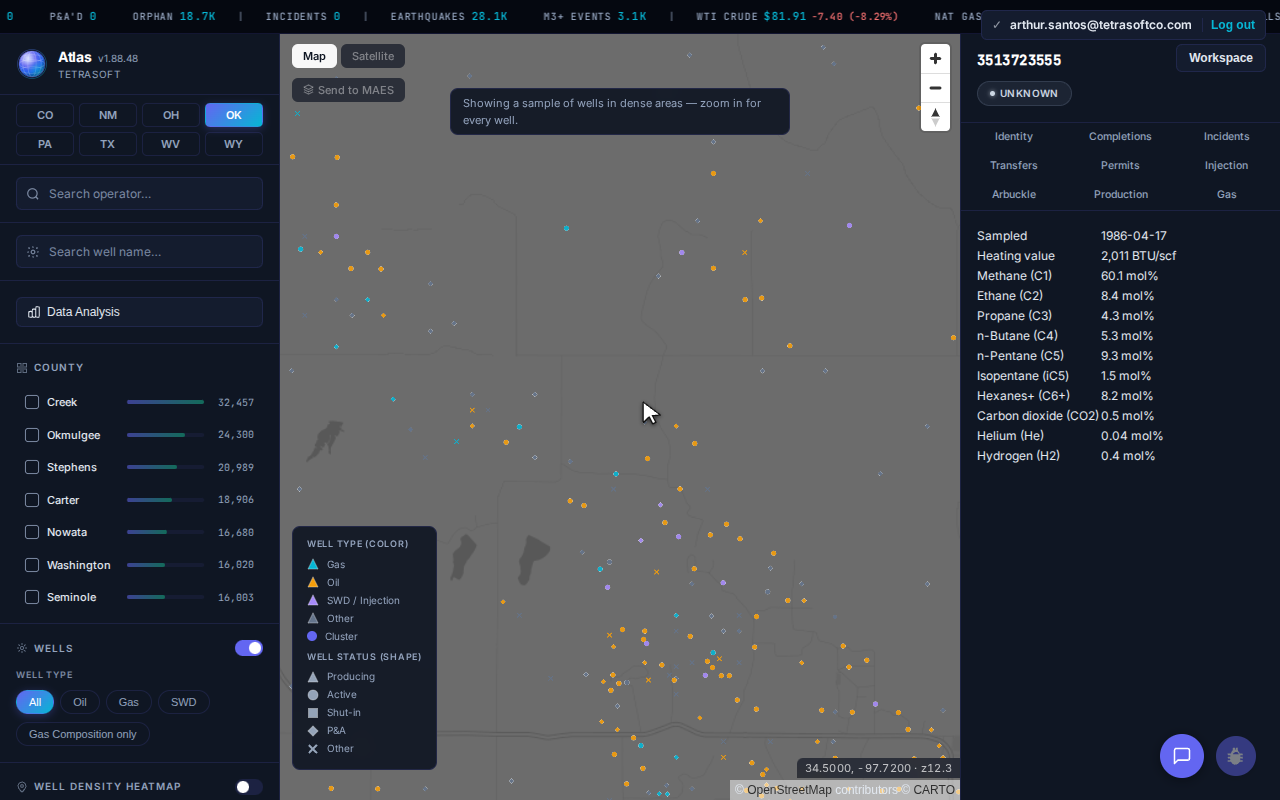
An Oklahoma gas well’s wellhead sample: heating value in BTU, methane, ethane, propane, CO2, and trace helium. [3]
TetraSoft Atlas Connects the OCC Records Oklahoma Keeps in Separate Tools
TetraSoft Atlas pulls Oklahoma wells and their gas composition into one connected view, keyed to each well’s API number [2]. OCC keeps the same information across the OCC Well Data Finder, an RBDMS Data Explorer, and an imaging system, with no shared map [1]. Instead of opening each tool and reconciling by hand, you get one record from one search.
Oklahoma is one of the eight states in TetraSoft Atlas, which together produced 68 percent of US crude oil and 83 percent of US marketed natural gas in 2025 [4]. Atlas is self-serve, with no sales call: you sign up and start a 7-day trial with no credit card [2].
What the OCC Tools Cannot Do in One View
An Oklahoma Corporation Commission well search shows records one lookup at a time [1]; Atlas connects them on one map [2].
| Capability | OCC tools | Atlas |
|---|---|---|
| Well, operator, and county lookup | Separate tools | One search box |
| Wellhead gas composition | Not shown together | Shown on the well |
| Statewide picture | One record at a time | A data analysis view |
| Multiple states | Oklahoma only | Eight states, one view |
| Time to an answer | Minutes of tab-switching | Seconds |
The comparison reflects the OCC tools’ publicly observable limitations, checked against the live OCC tools in July 2026. The time-to-answer difference reflects the overhead of switching between separate OCC tools versus a single map.
Every row above ships for Oklahoma today [2]. The difference is not more data; the difference is connected data.
TetraSoft Atlas Draws Oklahoma Data From OCC and USGS, Refreshed Monthly
TetraSoft Atlas draws every Oklahoma well from OCC records [1] and its gas composition from USGS [3]. Atlas does not invent numbers; the map connects the records these agencies already publish [2]. The Oklahoma data refreshes monthly, so a search returns current records [2].
Oklahoma is one of eight states in Atlas today, with more added over time [2]. You can open the same view for Texas, Colorado, New Mexico, Wyoming, West Virginia, Pennsylvania, and Ohio [2]. To look up a single well by its API number in any of those states, see the API well number lookup guide [2]. New Mexico carries the same kind of agency-record map, described in the NMOCD well search guide [2].
Where Oklahoma Oil and Gas Production Data Lives
Oklahoma oil and gas production data is not kept by the OCC. The OCC’s data page names the Oklahoma Tax Commission as the state’s official recordkeeper for production [5]. Production is registered there under a Production Unit Number (PUN), and one PUN can list several wells on a lease [6]. The Tax Commission offers a public PUN lookup by county or legal description [7].
Anyone searching for OCC production data therefore ends up with lease-level Tax Commission records. Atlas links OCC wells to those PUN records, so a linked well’s panel lists its lease’s reported oil, gas, and water by month. When several wells share the lease, the panel says how many.
For Oklahoma drilling permits, the OCC publishes Intent to Drill files that it updates daily [5]. Atlas maps active Intent to Drill permits as an overlay, and each well lists its own permits with type, approval date, and expiry. Compare plans and start a trial at TetraSoft Atlas.
See the Whole State at Once, Not Just One Well
Beyond the per-well record, Atlas includes a statewide data analysis view for Oklahoma [2]. The view summarizes well count and operators [2]. The view also splits wells by type, so you see how many produce oil versus gas [2].
The gas tab profiles heating value and carbon dioxide across every sampled well [3]. You move from a single well to the full Oklahoma picture without leaving the map [2]. Colorado carries the same statewide view, walked through in the Colorado oil and gas well map guide [2].
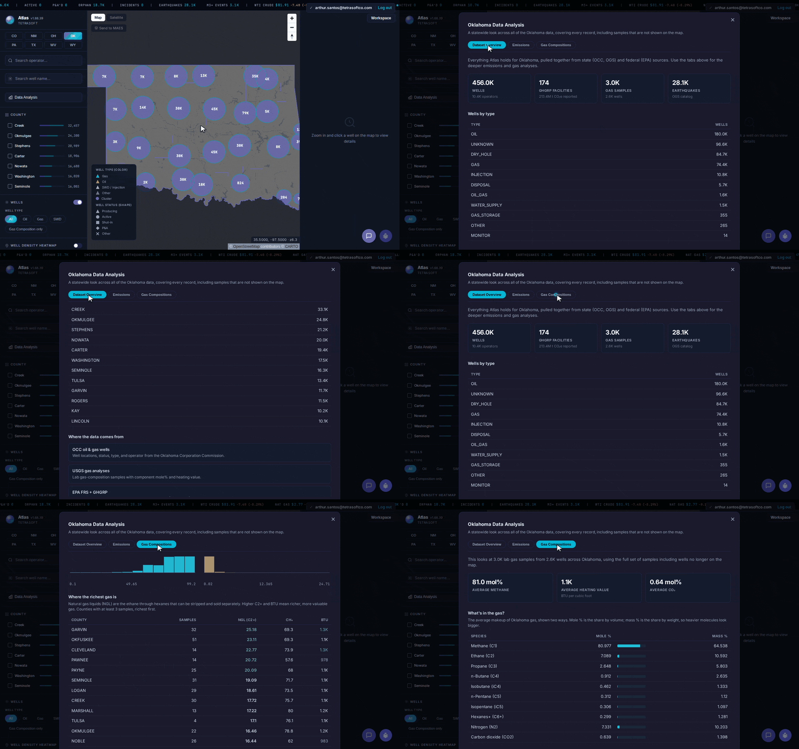
Oklahoma data analysis, from the statewide overview through gas composition. [2]
Frequently Asked Questions
What is OCC oil and gas?
OCC is the Oklahoma Corporation Commission, and its Oil and Gas Conservation Division regulates the state’s oil and gas wells [1]. Its search tools return permit and well records one lookup at a time [1]. Atlas maps the same public wells and adds gas composition and a statewide view [2].
Does TetraSoft Atlas replace OCC imaging?
No. OCC imaging holds the scanned well files, and Atlas does not reproduce those documents [1]. Atlas complements it by mapping the well’s identity and gas composition in one place [2]. You still open OCC imaging when you need the original filed paperwork [1].
Do all Oklahoma wells show gas composition?
Not every Oklahoma well has a gas sample on record [3]. Atlas shows wellhead gas composition for the wells that carry a lab analysis, drawn from USGS data [3]. Wells without a sample still map with their operator and county [2].
How many Oklahoma wells are on the map?
Creek County carries the largest count, about 33,000 wells, with Okmulgee and Stephens close behind in the historic Cushing and Seminole producing belt. The full dataset spans about 456,000 wells across all 77 Oklahoma counties. Each well carries its own identity and, where a lab sample exists, its gas composition [2].
How much does TetraSoft Atlas cost?
Atlas is priced by team size, starting at a single seat [2]. Every plan starts with a seven-day free trial, and you can cancel anytime [2]. For current plans and prices, see the Atlas pricing page [2].
An OCC oil and gas search should not mean three tabs and a manual reconcile. Atlas puts every well and its gas composition on one map, with the statewide picture a click away, refreshed monthly from OCC and USGS records [2]. Start your free 7-day trial.
This post is for informational purposes only and does not constitute legal or compliance advice. Consult qualified legal counsel or a compliance professional for guidance specific to your operations and jurisdiction.
References
- Oklahoma Corporation Commission (OCC) Oil and Gas Conservation Division public well records.
- TetraSoft Atlas, Oklahoma oil and gas dataset and product features. https://tetrasoftco.com/atlas-landing.html#pricing
- United States Geological Survey (USGS) gas composition analyses, as surfaced in TetraSoft Atlas.
- U.S. Energy Information Administration, crude oil field production and natural gas marketed production by state, annual 2025, accessed 23 September 2026. https://www.eia.gov/dnav/pet/pet_crd_crpdn_adc_mbbl_a.htm; https://www.eia.gov/dnav/ng/ng_prod_sum_a_EPG0_VGM_mmcf_a.htm
- Oklahoma Corporation Commission (OCC), Oil and Gas Data Files. https://oklahoma.gov/occ/divisions/oil-gas/oil-gas-data.html
- Oklahoma Tax Commission (OTC), Production Unit Number Registration or Change Request, Form 340. https://oklahoma.gov/content/dam/ok/en/tax/documents/forms/businesses/gross-production/340.pdf
- Oklahoma Tax Commission (OTC), Gross Production. https://oklahoma.gov/tax/businesses/gross-production.html
Comments
0Share your thoughts. All comments are moderated before appearing.
No comments yet. Be the first to share your thoughts!