The ODNR Well Locator is the interactive map the Ohio Department of Natural Resources publishes so anyone can find oil and gas wells statewide [1]. Its well layer carries 242,295 records, from producing Utica horizontals to wells plugged and abandoned decades ago [1]. Ohio’s other public tool, the Oil & Gas Well Database, returns active wells only [2]. That single limit sends most searches to the map, because the Locator’s inactive layer alone holds 177,139 wells [1]. Pull a well’s API number off that map, and TetraSoft Atlas, a subscription data platform, opens the same well’s production and inspection history [3].
Quick Answer: The ODNR Well Locator is the Ohio DNR’s free interactive map of all 242,295 Ohio oil and gas wells. It is the only ODNR tool that finds plugged, orphan, and expired-permit wells, because the Oil & Gas Well Database covers active wells only. Atlas adds the production volumes and inspection history the Locator leaves out.
Two ways to look up an Ohio well:
- Where it is, free: the ODNR Well Locator maps every Ohio well with its status and operator [1].
- What it produced and how it was inspected: TetraSoft Atlas opens each well’s annual production and full inspection record, free for 7 days [3].
Every ODNR count in this post was read from the division’s live well service on 20 August 2026. The numbers move as wells are permitted, plugged, and reclassified.
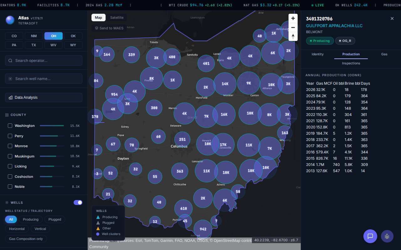
TetraSoft Atlas maps the same Ohio wells and opens each one’s production history, here the Shugert 4-1H in Belmont County. Open Ohio in Atlas, free for 7 days. [3]
Where to Open the ODNR Well Locator and What It Maps
If a search sent you to the gis.ohiodnr.gov map viewer, that one is retired. It now serves only a notice: “Ohio Oil & Gas Wells has a new GIS application… The old site is no longer being maintained and will be decommissioned.” [1] Search engines still rank the retired address highly, so it is a common way to arrive at a dead end.
The current build is the one ODNR links first from its own page [1]. ODNR links the current build from its own Well Locator page [1]. That build opens on ArcGIS Experience Builder, and the older viewer still answers at the gis.ohiodnr.gov map viewer address [1]. Both draw from the same ODNR well service, so the records match.
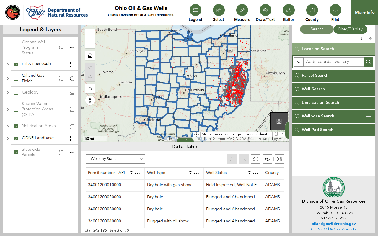
The ODNR Well Locator, with Ohio’s wells concentrated in the eastern counties. The record count sits at the bottom of the data table. [1]
One restriction catches people before they see a single well. ODNR’s Well Locator page states that “The Ohio Oil and Gas Well Locator is not accessible to locations outside the United States.” [1] A corporate VPN with a non-US exit node will trip the same block.
The map opens on a dialog with Disclaimer, Links, and Statewide Data tabs, which you close to reach the map [1]. Its search panel works as an Ohio gas well locator with six separate searches: location, parcel, well, unitization, wellbore, and well pad [1].
Finding Wells at an Address, and Within a Radius of It
The Location Search box takes an address, a coordinate pair, a township or a city [1]. Its own placeholder reads “Addr, coords, twp, city,” and a ZIP code is not one of the options [1]. A ZIP search returns nothing useful, which is worth knowing before you conclude the map has no wells near you. Enter the street address instead, or the township, which is how Ohio’s well records are organised in the first place [1].
A “gas wells near me” search is a radius question, and the map answers it with the Buffer tool on the top toolbar [1]. Search your address, then buffer a distance around the point to select every well inside it [1]. The selection lands in the data table below the map, where it can be exported [1]. That two-step is the closest the Locator comes to a proximity search, and nothing in the search panel does it on its own.
The panel’s other five searches are for when you already know an identifier: parcel, well, unitization, wellbore, and well pad [1].
What a Well Returns When You Click It
Clicking a well opens its identity and location, not its history [1]. The record carries the API number, well name and number, status, county, and township [1]. It also holds the operator with address and phone, wellhead and bottom-hole coordinates, drillhole slant, and producing formation [1]. Separate layers isolate active wells, inactive wells, horizontal and directional bores, and orphan status [1].
Ohio’s well population skews old and idle. Plugged and abandoned wells are the single largest status at 68,020, ahead of 60,919 producing wells [1]. Another 26,813 wells carry the status “Unknown status,” and 4,754 wells are drilled horizontally [1].
The status list itself has a wrinkle worth knowing before you filter. It contains both “Expired Permit” with 23,375 wells and “Permit Expired” with 4,448 wells, as two separate values in the same field [1]. Filtering on either label alone drops most of the wells you meant to catch.
Locator or Well Database: Which ODNR Tool Answers Your Question
Pick the tool by whether your well is active, because that single question decides which one can see it. The Well Locator maps every well ODNR holds a location for [1]. The Oil & Gas Well Database returns tabular records, searched by county, township, or operator name [2]. Its own search page states that “Only active wells are included in this search.” [2]
| Your question | The tool that answers it |
|---|---|
| Where is this well on the ground? | Well Locator |
| Is there a plugged or orphan well on this parcel? | Well Locator |
| Which wells does this operator run right now? | Oil & Gas Well Database |
| What is this well’s API number? | Well Locator |
| How much has this well produced? | Neither, see below |
The split matters more than it looks. ODNR’s Locator sorts Ohio’s wells into an active layer of 65,156 and an inactive layer of 177,139 [1]. Roughly three of every four Ohio wells therefore fall outside what the ODNR oil and gas well search will return.
Production is the gap neither tool closes on the well itself. ODNR reports oil and gas production on a separate page under Well Information, away from both the map and the database [4]. Answering “what did this well make last year” means leaving the Locator entirely. An Ohio oil and gas well map that carries production on the well saves that trip.
Oil and Gas Wells or Water Wells: Two Separate ODNR Systems
ODNR runs a second, larger well database that has nothing to do with oil and gas [5]. The Ohio Water Well Database holds “the records of 904,714 water wells and 128,251 well sealing reports filed in the state of Ohio,” [5] against the Locator’s 242,295 oil and gas wells [1]. Water wells outnumber oil and gas wells there by roughly four to one [5].
Neither system contains the other’s wells. A domestic water well will not appear on the Oil & Gas Well Locator at any zoom. A plugged Utica horizontal will not appear in the water-well records. Searching for “ODNR well locator” or “Ohio well locator” returns both, so the first thing to settle is which kind of well you are looking for.
| What you are looking for | Where it lives |
|---|---|
| An oil, gas, injection or storage well | Oil & Gas Well Locator |
| A domestic, livestock or monitoring water well | Ohio Water Well Database |
| A well sealing report | Ohio Water Well Database |
| An orphan or plugged oil and gas well | Oil & Gas Well Locator |
Orphan Wells Appear on the Locator and Nowhere Else
Orphan wells are the case where the Locator earns its place outright. Its orphan layer carries 10,271 wells, and the base well layer flags each one’s Orphan Well Program status [1]. Ohio also lists 2,212 wells as “Orphan Well - Ready” and 548 as “Orphan Well - Pending.” [1]
Landowners searching for abandoned gas wells on a parcel should start on the Locator, then confirm the identity with an API well number lookup.
What the Well Locator Leaves Out, and Where to Get It
The Locator gives you one date and one year per well, never a history [1]. Its wells carry a last inspection date and a last non-zero production year, and no volume field of any kind [1]. Those two fields are also thinly populated: 95,934 wells carry a last inspection date and 83,183 carry a last production year [1].
Six in ten of the map’s 242,295 wells therefore show no inspection date, and two in three show no production year [1].
Take one real well. Ohio API 3401320706 is the Shugert 4-1H in Kirkwood Township, Belmont County [1]. The Locator returns a single line for it: Gulfport Appalachia, producing, Point Pleasant Formation [1]. It adds a last inspection of April 8, 2026, and a last production year of 2026 [1].
Atlas opens the same API number with 14 years of annual production, from 2013 through 2026 [3]. Gas fell from 1,685,205 Mcf in 2014 to 79,133 Mcf in 2024, a drop of about 95% [3]. A decline that steep is the normal shape of a Utica horizontal, and a single last-production year hides all of it.
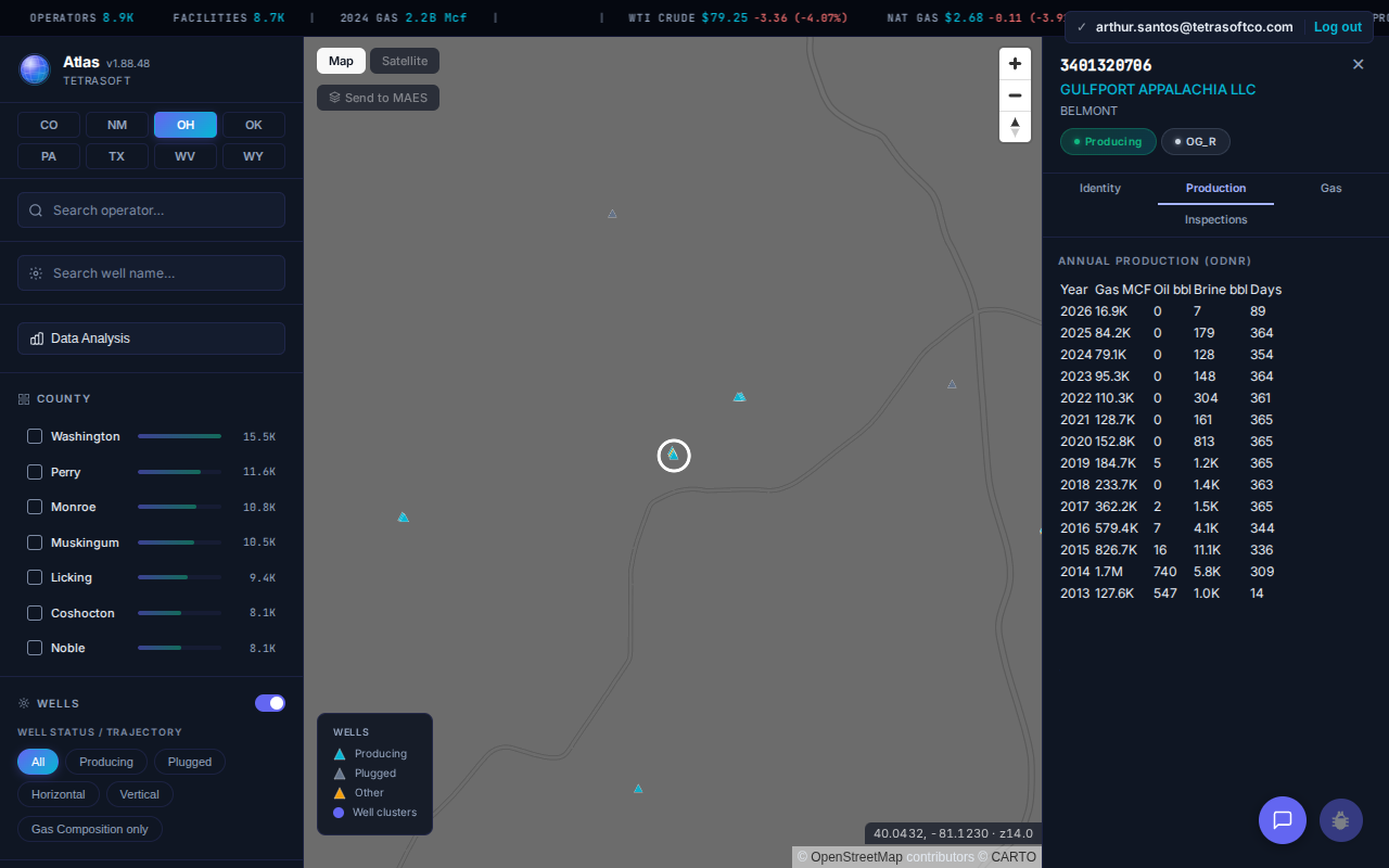
Fourteen years of ODNR-reported annual production on one Ohio well, against the single year the Well Locator carries. [3]
The inspection record separates the two tools the same way. Atlas returns 12 inspections for that well, running from October 2013 to April 2026 [3]. Each row carries its date, inspection type, violation flag, and compliance status [3].
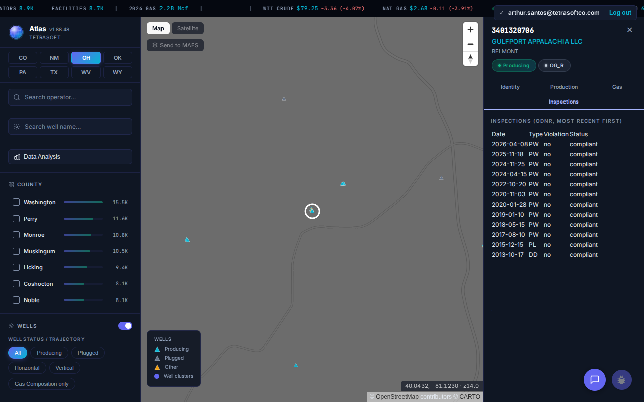
Twelve ODNR inspections on one well, most recent first. The Well Locator carries the top date only. [3]
Atlas holds 242,180 Ohio wells against the Locator’s 242,295, so both cover the same population [3].
Paying Adds Emissions, Statewide Totals, and Seven More States
The Locator answers where a well is, and Atlas answers what it has been doing.
| For one Ohio well | ODNR Well Locator | Atlas |
|---|---|---|
| Annual production volumes | No | 14 years on the well above |
| Inspection history | Last date only | Every inspection, with the inspector’s comment |
| Reported emissions | No | EPA GHGRP and FRS records |
| Gas composition | No | Where samples exist |
| Wells outside Ohio | No | Seven more states |
Past the single well, Ohio’s Atlas records run to 26.7 billion Mcf of gas and 533 million barrels of oil [3]. The same records span 8,885 operators and 8,691 facilities [3]. The emissions layer adds 12 Ohio facilities reporting to the EPA Greenhouse Gas Reporting Program, with annual CO2e back to 2013 [3]. No ODNR well tool carries emissions at all [1].
Coverage runs to eight states: Colorado, New Mexico, Ohio, Oklahoma, Pennsylvania, Texas, West Virginia, and Wyoming [6]. An operator holding acreage in Ohio, Pennsylvania, and West Virginia works three separate state portals today.
A landowner checking one parcel should use the free Ohio oil well locator and stop there. The subscription earns its keep on repeat work: diligence across a portfolio, inspection history on many wells, or any question that crosses a state line.
Atlas has its own limits. It keys wells on the 10-digit API, so the two bores ODNR lists separately under 3401320657 collapse into one Atlas record [3]. ODNR also remains the system of record, so for a single well’s authoritative current status, its own map is the reference.
Frequently Asked Questions
Is the ODNR Well Locator free to use?
Yes. The Ohio Oil & Gas Well Locator is a free public map from the Ohio Department of Natural Resources, and it requires no account or login [1]. The Division of Oil and Gas Resources Management runs it as a public service and lists a support line, 614-265-6922, on the map [1].
Can I download Ohio’s well data instead of using the map?
Yes. ODNR offers Oil & Gas Data by County for download from the Data tab of the Well Locator [1]. It also publishes field-description files for the well, wellbore, well pad, unitization, and horizontal drilling unit layers [1]. The same records are served through the division’s public ArcGIS map service, which is what the map itself reads [1].
What do the last four digits of an Ohio API number mean?
Ohio API numbers in the Well Locator run to 14 digits, and the final four identify the specific wellbore [1]. Well 3401320657 returns 34013206570000 for the original vertical hole and 34013206570100 for the horizontal [1]. Two bores sit under one well identity, which is why a search on the shorter number returns both.
Can I search the ODNR Well Locator by ZIP code?
No. The map’s Location Search accepts an address, a coordinate pair, a township, or a city, and ZIP is not among them [1]. Enter the street address instead. To find every well around a point rather than at it, start from the address [1]. Then use the Buffer tool to select wells within a set distance [1].
Why do so many Ohio wells show no operator?
ODNR lists 118,120 wells under the operator name “HISTORIC OWNER,” roughly half of all its records [1]. Those are wells with no current registered owner on file, most of them long out of production. Some records instead read “UNREGISTERED OWNER.” [1]
How accurate are the well locations on the map?
ODNR states that the data “are derived from multiple sources and the locational quality may be varied.” [1] It adds that locations “may require additional research and/or professional surveying to achieve desired accuracy.” [1] The division also states it does not warrant the data [1]. Treat a mapped point as a starting location for older wells, not a survey.
Start on the ODNR Well Locator to find the well, then open Atlas for what it produced and how it has been inspected. Atlas carries 242,180 Ohio wells with production and inspection history on each one, across eight states in one view [3].
This post is for informational purposes only and does not constitute legal or compliance advice. Consult qualified legal counsel or a compliance professional for guidance specific to your operations and jurisdiction.
References
- Ohio Department of Natural Resources, Division of Oil and Gas Resources Management, Oil & Gas Well Locator and DOG_Services/Oilgas_Wells_public map service, queried August 20, 2026
- Ohio Department of Natural Resources, Ohio Oil & Gas Well Database (RBDMS), apps.ohiodnr.gov
- TetraSoft Atlas, Ohio dataset, queried July 28, 2026
- Ohio Department of Natural Resources, Oil and Gas Production, Well Information, ohiodnr.gov
- Ohio Department of Natural Resources, Ohio Water Well Database, waterwells.ohiodnr.gov, queried August 20, 2026
- TetraSoft Atlas, state coverage listing, tetrasoftco.com/data, queried August 20, 2026
Comments
0Share your thoughts. All comments are moderated before appearing.
No comments yet. Be the first to share your thoughts!