Pennsylvania has about 279,000 oil and gas wells on record with the Department of Environmental Protection (DEP), across 58 counties. About 189,000 of them carry coordinates and appear on the map; much of the remainder was permitted and never drilled. The DEP’s PA Oil and Gas Mapping tool shows well locations, but production, inspections, and waste reports sit in separate report systems [1]. Assembling one well’s full picture means moving between the map and each of those report pages by hand. TetraSoft Atlas, a subscription data platform, draws those DEP records into one interactive Pennsylvania oil and gas map, searchable by operator or county [2]. Each result opens the well with its full record attached, from permit to latest production [2].
Quick Answer: Pennsylvania has about 279,000 oil and gas wells across 58 counties on DEP record, of which about 189,000 are mapped, including roughly 25,000 unconventional wells. TetraSoft Atlas maps them on one screen, cross-linked with production, inspections, and permits [2].
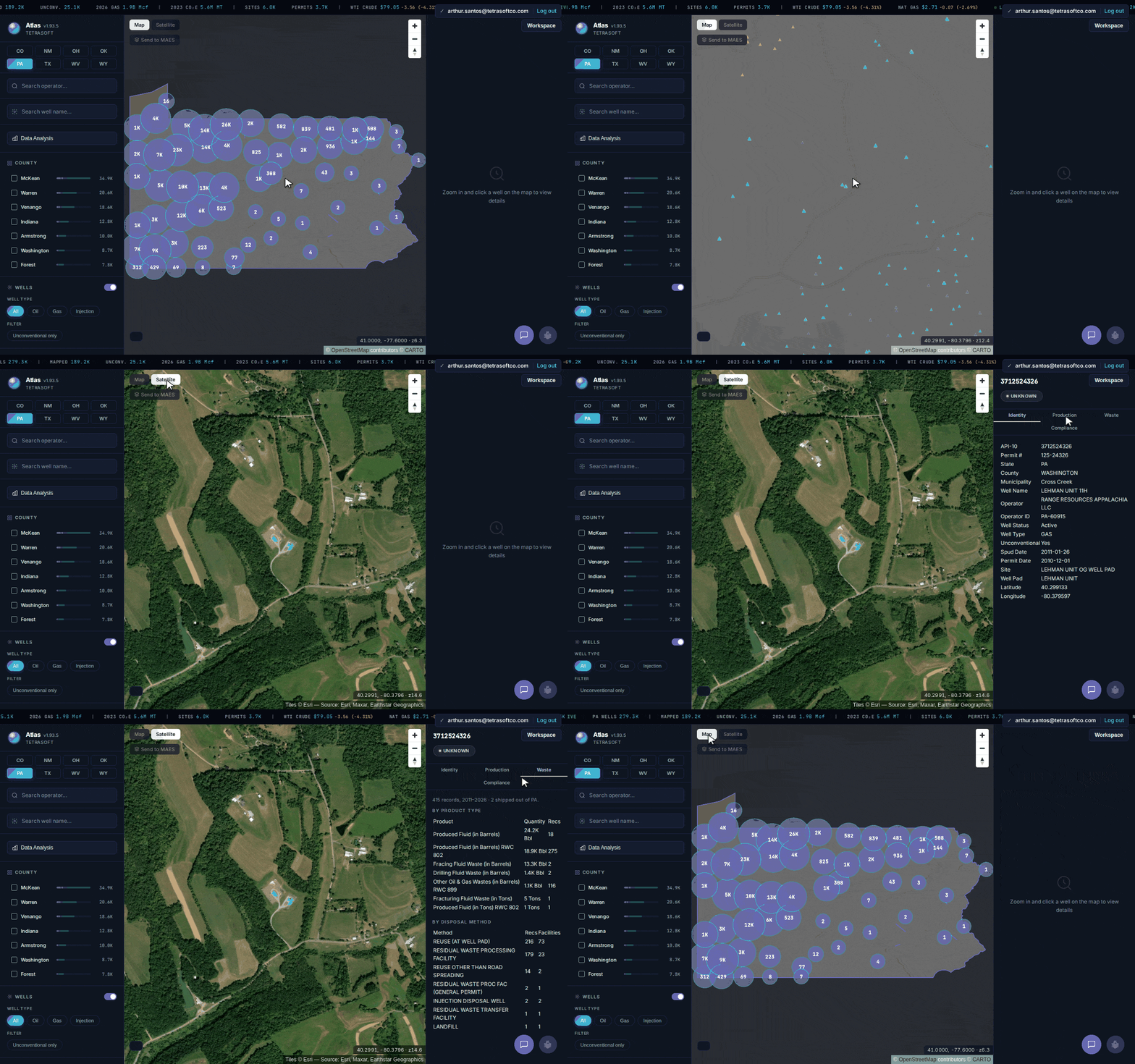
Every Pennsylvania well on one map, from statewide clusters down to a single well’s permit, production, and inspections. [2]
Search Every Pennsylvania Well and Open Its Full Record
For a Pennsylvania oil and gas well search, TetraSoft Atlas returns the state’s mapped wells from a single search box [2]. You search by well name or operator, or filter by county, without paging through separate DEP report systems [2]. Every result opens the well with its full record attached [2].
The map clusters wells statewide, then resolves to individual wells as you zoom in [2]. From a statewide view of about 189,000 mapped wells, you drop straight into a single pad in the Marcellus fairway or the historic northwestern oil fields. Satellite imagery sits behind the map, so a well’s pad and surroundings are visible at the same zoom [2].
Production sits next to the inspection record on the same screen [2]. Annual volumes line up against the permit and the DEP inspection history for that well [2]. You can run that same lookup on the Pennsylvania oil and gas map in a few seconds [2].
What the DEP Records Show for Each Well
The DEP record behind each Pennsylvania well covers its permit, production, and inspection history [1]. Atlas carries about 1.5 million monthly production records and more than 770,000 DEP inspection records. That history is attached to each well, not spread across separate report downloads [2]. For PA drilling permits, each well’s Atlas record shows its DEP permit number and permit date [2].
Pennsylvania splits into two very different well populations [1]. About 25,000 wells are flagged unconventional, most of them horizontals, while the rest are conventional and shallower. Atlas flags each well’s type and status, so you can turn the map into a Pennsylvania gas well map of unconventional wells only [2].
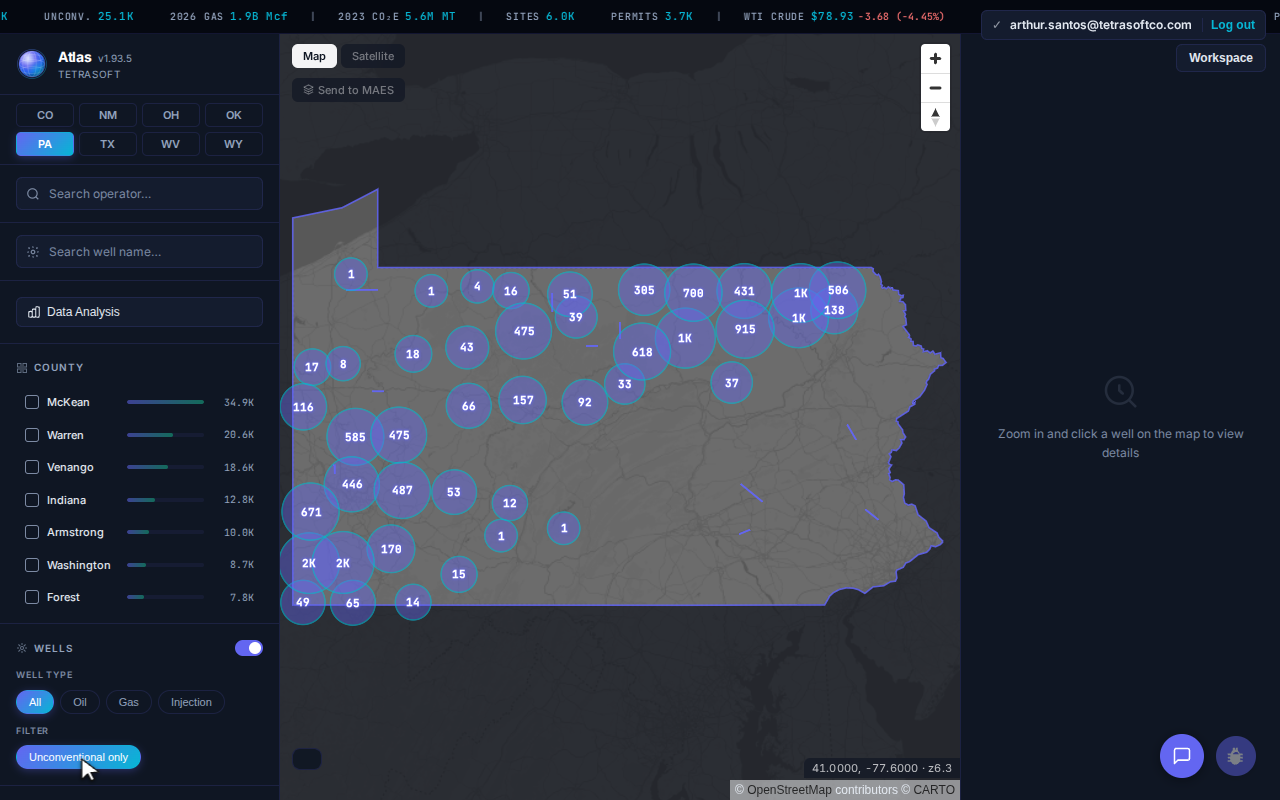
Unconventional wells only: the Marcellus and Utica fairways separate from Pennsylvania’s conventional inventory, leaving the southwest and northeast lit and the northwestern oil counties nearly empty.
Operators are attached to every well [2]. About 8,100 distinct operators appear across the Pennsylvania dataset, from major Marcellus producers to legacy conventional operators. Searching by operator pulls their full Pennsylvania footprint onto the map at once [2].
Pennsylvania Gas Production Data: Monthly and Annual Reports
The DEP collects Pennsylvania gas production data on two schedules, set by well type [3]. Unconventional wells report every month, within 45 days after the month ends [3]. Conventional wells file one report a year, due by February 15 for the prior calendar year [3].
That split shapes any PA gas well production lookup, Marcellus production data included. An unconventional well carries a monthly series, while a conventional well carries one total per year [3]. In Atlas, each well’s Production tab charts gas, oil and condensate year by year, with a table of annual volumes beneath [2]. See Atlas plans and start a free trial to open any Pennsylvania well’s production.
Why Pennsylvania’s Well Records Are Hard to Search
A PA DEP well search is hard because more than 160 years of drilling left Pennsylvania’s records spread across separate DEP systems [1]. The commercial oil industry began at Drake’s 1859 well in Venango County, and McKean, Warren, and Venango counties still hold the most wells today. A single well’s history can span multiple legacy systems as a result.
Abandoned wells make the fragmentation worse. More than 20,000 wells sit on the DEP’s abandoned list, and tens of thousands more are recorded as plugged, orphaned, or abandoned. For what those wells are and where they turn up, see Abandoned Gas Wells: What They Are and Where to Find Them.
Atlas removes the reconcile step [2]. One search resolves the well, and its location, permit, production, and inspections open together [2]. The data refreshes monthly from DEP records, so a lookup returns current data [2].
Frequently Asked Questions
What Is PA DEP Oil and Gas Mapping?
PA DEP oil and gas mapping refers to the Pennsylvania Department of Environmental Protection’s public tools for locating oil and gas wells [1]. The DEP map shows well locations, while production, inspection, and waste data live in separate report systems [1]. Atlas answers the same search on one map, with those records attached to each well [2].
Can You Search Pennsylvania Wells by API or Operator?
Yes, an API number or an operator name are the two most direct ways to find a Pennsylvania well in DEP records [1]. In Atlas, you search by well name or operator, and each well’s record shows its API number [2]. Pennsylvania wells carry the state API prefix 37, followed by a county code and a unique well number [1]. For how to read those digits, see API Well Number Lookup: What It Is and How to Read One.
Does It Include Abandoned and Plugged Wells?
Yes, the Pennsylvania map includes active, plugged, and abandoned wells across every DEP status [1]. More than 20,000 wells carry the DEP abandoned list status, and about 15,000 of them have coordinates and appear on the map alongside active production. A plugged or abandoned well keeps its record and location on the map [2].
How Current Is the DEP Data?
Atlas refreshes its Pennsylvania data monthly from DEP records. A search returns the latest permits, production, and inspections the DEP has published, not a one-time download [2]. Older wells keep their full history, so the record spans decades [2].
How Much Does TetraSoft Atlas Cost?
Atlas is priced by team size, starting at a single seat [2]. Every plan starts with a seven-day free trial, and you can cancel anytime [2]. For current plans and prices, see the Atlas pricing page [2].
Pennsylvania oil and gas mapping should not mean the DEP map in one tab and reports in three more. Atlas puts every well and its permit, production, and inspections on one map, refreshed monthly from DEP records [2]. Start your free 7-day trial.
This post is for informational purposes only and does not constitute legal or compliance advice. Consult qualified legal counsel or a compliance professional for guidance specific to your operations and jurisdiction.
References
- Pennsylvania Department of Environmental Protection (DEP), Office of Oil and Gas Management public well, permit, production, inspection, and waste records.
- TetraSoft Atlas, Pennsylvania oil and gas dataset and product features. https://tetrasoftco.com/atlas-landing.html#pricing
- Pennsylvania Department of Environmental Protection, Office of Oil and Gas Management, Oil and Gas Production and Waste Reporting Manual (May 17, 2018) and Unconventional Wells Monthly Production Reporting Guide (April 28, 2020), accessed September 28, 2026. https://files.dep.state.pa.us/oilgas/bogm/bogmportalfiles/oilgasreports/Greenport/Userguides/Oil%20and%20Gas%20Reporting%20Electronic%20Production%20and%20Waste%20Reporting%20Guide.pdf; https://files.dep.state.pa.us/oilgas/bogm/bogmportalfiles/oilgasreports/Greenport/Userguides/Oil%20and%20Gas%20Reporting%20Electronic%20Unconventional%20Well%20Monthly%20Production%20Guide.pdf
Comments
0Share your thoughts. All comments are moderated before appearing.
No comments yet. Be the first to share your thoughts!