Ask how many oil fields Texas has and you get two different right answers, 65,038 and 23,923 [1]. Both come from the same well records; they differ because Texas files a field under many names at once [1]. The field name is how almost every Texas well gets looked up. On its own it tells you nothing about whether anyone still drills there. This post covers what a field name is, which fields are largest, and where they sit. It ends with the one number that separates fields drilled today from those drilled decades ago. Every name resolves to its wells in TetraSoft Atlas, our subscription platform joining well, production and operator records across eight states [1].
Quick Answer: Texas well records carry 65,038 field designations that roll up to 23,923 fields, as of September 2026. Of those fields, 22,526 contain no horizontal well at all, and just 241 are majority horizontal. Statewide, 86,479 of 851,163 wells are horizontal, which is 10.2%.
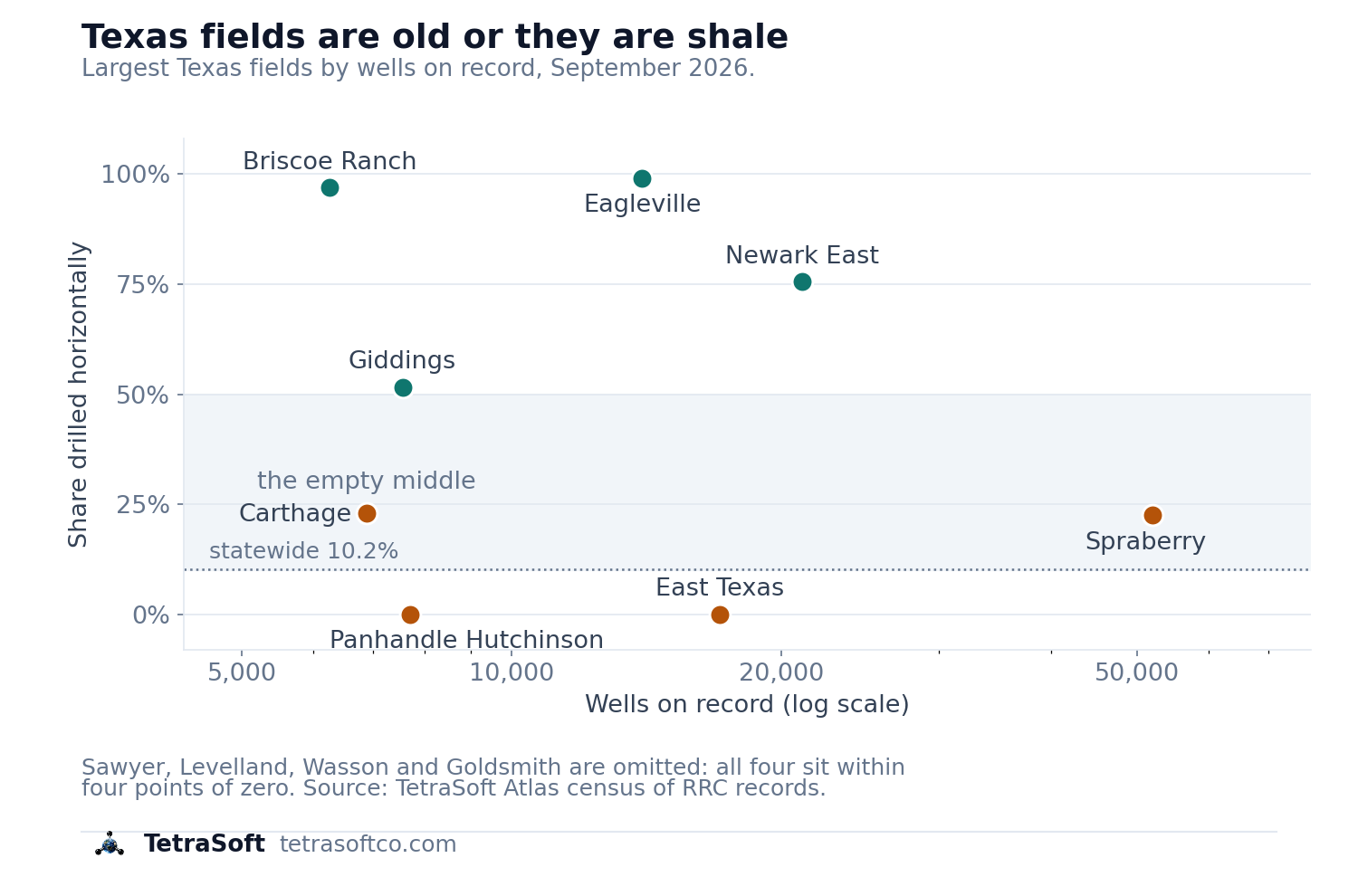
Texas fields cluster at the extremes: legacy inventory near zero horizontal, shale fields near 100%, with little in between. [1]
Why One Texas Field Has Many Names
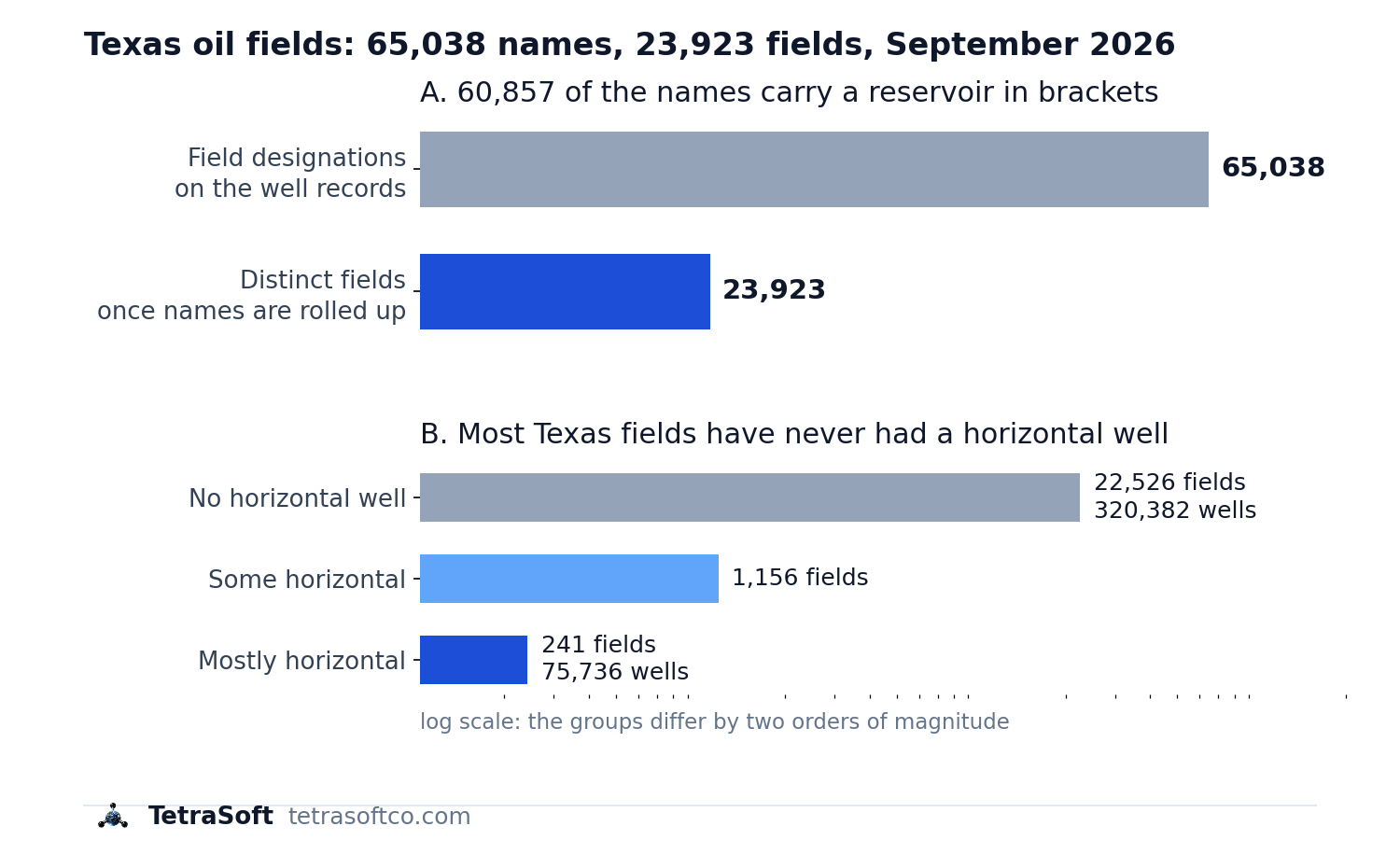
The name count and the drilling split, the two numbers the rest of this post turns on. [1]
A field is the underground accumulation itself, and a designation is one of the names the Railroad Commission files it under [1]. One field usually answers to several designations at once, because the Commission names each producing reservoir separately [1]. Of the 65,038 designations, 60,857 name a reservoir in brackets after the field name [1]. SPRABERRY (TREND AREA) and PHANTOM (WOLFCAMP) are two of them [1]. Strip that bracketed part and the remaining name is the field; keep it and you are counting reservoirs [1]. Eagleville is filed under nine separate designations, Giddings under thirty, and Carthage under eighty-nine [1]. Ranking fields without rolling those up splits one field into several and buries it.
Every count here is a distinct wellbore, meaning one physical hole in the ground, rather than one record, meaning one line in the Commission’s file [1]. Texas files one row per field completion, so a wellbore producing from three reservoirs appears three times, once under each field [1]. Counting rows instead inflates the state by roughly a quarter [1]. That is the single easiest way to publish a wrong Texas number.
Two groupings sit outside the field count and should stay outside it. Wildcat covers exploratory wells in counties right across the state, which no reservoir does [1]. Ten more groupings named for a county, led by Wichita County Regular, collect shallow legacy wells rather than a single field [1].
Published rankings often leave those in, which is why a county grouping sometimes appears among the largest Texas fields. What a field record actually represents is covered in Oil Field Map: How to Find Any Named Field’s Wells.
| Field | Designations | Wells | Counties | Horizontal |
|---|---|---|---|---|
| Spraberry | 15 | 52,022 | 26 | 11,720 |
| Newark East | 13 | 21,122 | 26 | 15,952 |
| East Texas | 2 | 17,078 | 6 | 1 |
| Eagleville | 9 | 13,987 | 14 | 13,862 |
| Panhandle Hutchinson County | 1 | 7,708 | 4 | 0 |
| Giddings | 30 | 7,555 | 24 | 3,895 |
| Carthage | 89 | 6,887 | 10 | 1,580 |
| Briscoe Ranch | 4 | 6,265 | 8 | 6,072 |
Texas’s largest fields by distinct wellbores, September 2026, with designations rolled up and catch-all groupings excluded. [1]
A Field Name Can Span Two Dozen Counties
Spraberry reaches across 26 counties and Newark East across 26 as well [1]. A name covering that much ground is a reporting label, not a location. Anyone using a field name as a proxy for where wells sit will be wrong by counties at a time. At the other end of the range, 7,445 fields hold exactly one well each [1].
Which Fields Are Still Being Drilled
Most Texas fields have never seen a horizontal well [1]. Exactly 22,526 of the 23,923 fields contain none, and together they hold 320,382 wells [1]. Another 1,156 fields hold a mix, and just 241 are majority horizontal [1]. Between them the 241 carry 75,736 wells [1].
The contrast inside the largest fields is sharper than the statewide figure suggests. Eagleville is 99.1% horizontal and Briscoe Ranch is 96.9% [1]. East Texas, with 17,078 wells, has one horizontal well in the whole field [1]. Panhandle Hutchinson County has none at all across 7,708 wells [1].
That gap surprised me, because both groups answer to the same phrase. Statewide, horizontal wells are 86,479 of 851,163, or 10.2% of the total [1]. Counts here move as wells are drilled, transferred and plugged, so treat them as a September 2026 snapshot.
Newark East Holds More Horizontals Than Any Other Field
Newark East carries 15,952 horizontal wells, more than any other Texas field [1]. Eagleville follows with 13,862, and Spraberry with 11,720 [1]. Spraberry is the largest field in the state and only 22.5% horizontal, which the headline ranking hides.
How TetraSoft Atlas Finds a Texas Field’s Wells
TetraSoft Atlas resolves any Texas field designation to the wells that carry it, with their counties, operators and status attached [1]. The Railroad Commission publishes the field name on each well record, so the label exists in the source data [1]. The wells are the evidence.
Texas produced 42 percent of US crude oil in 2025, more than any other state [7]. Atlas is self-serve, with no sales call: you sign up and start a 7-day trial with no credit card [6].
Those well records carry a name and a coordinate per well, and no boundary geometry [1]. A field drawn from them is therefore drawn from its wells.
Where the Largest Fields Actually Sit
A field’s wells are the only record of where it is [1]. Placing each of the twenty largest families at the median coordinate of its own wells puts the two eras in different parts of the state [1].
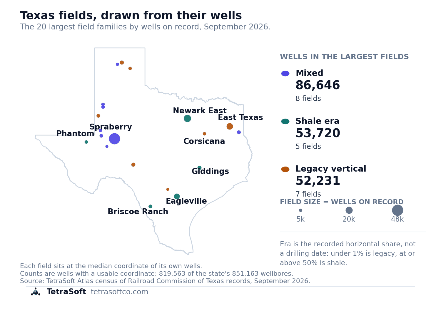
Newark East sits under the Fort Worth metroplex [1]. Eagleville and Briscoe Ranch sit well to the south, and Spraberry and Phantom to the west [1]. The legacy inventory is spread far more widely, from East Texas in the northeast to Somerset below San Antonio [1].
Three of the twenty are Panhandle groupings, and their spread gives them away. Panhandle Hutchinson County Fld. spans more than four degrees of latitude [1]. That is the shape of an administrative bucket rather than a field.
Counts on the map are wells carrying a usable coordinate, 819,563 of the state’s 851,163 wellbores [1]. The remaining 3.7% cannot be placed, so they sit in the field totals but not on the map.
Atlas will not hand you a field outline, because the Commission’s well records carry no boundary to draw [1]. What it does is let a field name behave like a filter rather than a label [1]. All 52,022 Spraberry wells resolve to a map, a county list and an operator list in one step [1]. Texas well records reach Atlas through the same pipeline described in RRC Wellbore Query: How to Find Any Texas Well Record.
The error this prevents is mistaking a field’s size for its activity. Screening acreage on field name alone ranks East Texas above Eagleville by a fifth [1]. One of them has a single horizontal well, and the other is drilled almost entirely that way [1]. The same question runs across the Permian, where two states’ registers disagree before anyone counts a field.
Frequently Asked Questions
How many oil fields does Texas have?
The Railroad Commission’s well records carry 65,038 field designations [1]. Those roll up to 23,923 field names once the parenthetical reservoir suffixes are stripped [1]. Both figures are counts taken from the well records rather than a total quoted from the agency [1]. Which number answers the question depends on whether you want names or reservoirs.
Which Texas field has the most wells?
Spraberry leads with 52,022 wells across 26 counties, counting all fifteen of its designations together [1]. Newark East follows with 21,122 and East Texas with 17,078 [1]. Published rankings often answer this with East Texas instead, because they rank by cumulative production rather than by well count.
Why does a Texas field count differ from a well count?
Texas files one record per field completion rather than per well [1]. A wellbore producing from three reservoirs appears three times, once under each field name [1]. Counting records rather than distinct API numbers overstates the state’s well count by about a quarter [1]. Every figure here counts distinct wellbores [1].
How do I find out which Texas oil field my property sits in?
Start from the wells, not from a map. Every Texas well record names the field it produces from [1]. The records carry no field boundary at all [1]. Read the field name on the wells nearest your tract.
What are Texas field rules, and do they affect royalties?
The Railroad Commission can adopt special rules for a single designated field [2]. Spacing, density and allowable are set by the statewide rules except where a field’s own rules replace them [2]. The rules set well spacing, proration-unit acreage and the per-well oil allowable [2]. They replace the statewide rules for that field alone [2]. The Commission has no authority over lease or royalty payments [2]. Field rules shape permitted production, while the lease governs your share of it.
What is the oldest oil field in Texas?
Corsicana is generally treated as the first commercially important Texas field [3]. It was discovered on 9 June 1894 by a crew drilling a municipal water well [3]. It still appears in Commission records as CORSICANA (SHALLOW) [1]. An earlier well was drilled at Oil Springs in 1866, with sustained production there from 1887 [4]. So the first well and the first important field are not the same answer.
Is Spindletop still producing?
Yes, though barely [5]. Spindletop remains a designated field on the Commission’s September 2026 oil proration schedule [5]. That schedule lists 132 wells and 157,449,888 barrels produced since discovery [5]. Much of the salt dome’s present use is underground storage and brine disposal rather than oil [5]. Accounts that describe the field as finished are out of date.
How many oil and gas wells does Texas have?
The records carry 851,163 distinct wellbores [1]. Of those, 86,479 are horizontal, which is 10.2% [1]. That count includes plugged and permitted wells, not only producers [1].
How much does TetraSoft Atlas cost?
Atlas is sold on subscription, with plans scaled from an individual analyst to a large operator team [6]. Every paid plan starts with a seven-day free trial, and you can cancel anytime [6]. For current plans and prices, see the Atlas pricing page [6].
Every Texas field resolves to its wells, counties and operators on one map [1]. The horizontal share comes with it, so you can tell which era a field belongs to [1]. Start your free 7-day trial.
This post is for informational purposes only and does not constitute legal or compliance advice. Consult qualified legal counsel or a compliance professional for guidance specific to your operations and jurisdiction.
References
- TetraSoft Atlas, Texas dataset from Railroad Commission of Texas records
- Railroad Commission of Texas, special field rules and Statewide Rule 45, 16 Texas Administrative Code 3.45
- Texas State Historical Association, Handbook of Texas, Corsicana Oilfield
- Texas State Historical Association, Handbook of Texas, Oil Springs, Texas
- Railroad Commission of Texas, oil proration schedule effective September 1, 2026
- TetraSoft Atlas pricing page, tetrasoftco.com/atlas-landing.html
- U.S. Energy Information Administration, crude oil field production and natural gas marketed production by state, annual 2025, accessed 23 September 2026. https://www.eia.gov/dnav/pet/pet_crd_crpdn_adc_mbbl_a.htm; https://www.eia.gov/dnav/ng/ng_prod_sum_a_EPG0_VGM_mmcf_a.htm
Interactive tool
Texas field era lookup
Texas files 65,038 field designations that roll up to 23,923 fields. The 386 with 250 wells or more are listed here, with the horizontal share that separates the two eras.
Rolled up from every designation the Commission files for that field
Share drilled horizontally in Spraberry
22.5%
Mixed. Vertical inventory with horizontal drilling layered over it.
- Wells on record
- 52,022
- Horizontal wells
- 11,720
- Field designations
- 15
- Counties
- 26
- Most wells in
- Midland
- Operators on record
- 884
- Most wells held by
- Pioneer Natural Res. USA, Inc.
TetraSoft Atlas census of Railroad Commission of Texas records, September 2026. Counts are distinct wellbores, because Texas files one record per field completion. The era label reads the recorded horizontal share and is not a drilling date. Nothing leaves your browser.
Comments
0Share your thoughts. All comments are moderated before appearing.
No comments yet. Be the first to share your thoughts!