An oil field is an administrative name, not a drawn shape [1]. Every producing state runs its own version of that idea, assigning its own names to its own wells under its own rules. Texas carries 55,791 field names, Colorado 1,556, and Wyoming 1,174.
Where a state does publish field polygons, it draws them by tracing the wells that carry each name [2]. That makes the wells the answer in either case, and every well carries its field name in TetraSoft Atlas, a subscription data platform [3].
Quick Answer: A field name belongs to one state’s records, so there is no national field list. Texas well records carry 55,791 distinct field names, Colorado 1,556, and Wyoming 1,174. Colorado and Wyoming publish field outlines built by grouping wells; Texas publishes none [2]. Either way you see a field by mapping the wells assigned to it, which Atlas does on one screen [3].
What a Field Is in the Well Records
A field in the records is a label the regulator attaches to wells, and nothing more [1]. The Railroad Commission describes a field name as one “assigned by the Commission” to a geographic area [1]. That area is where wells produce from one or more continuous reservoirs [1]. The underlying reservoir is the physical thing, defined as porous, permeable rock holding commercial quantities of oil and gas [1].
How completely the label gets applied varies by state, which is the first surprise in the data. Of the 1,215,178 Texas wells on record, 363,684 carry no field name at all, just under 30 percent of the state’s wells. Colorado assigns a field to 125,543 of its 125,717 wells, and Wyoming to 69,633 of 69,735. Both of those states leave roughly one well in a thousand unlabeled, against nearly one in three in Texas.
The three states also name fields at wildly different resolutions. Texas carries about thirty-six times as many field names as Colorado despite having under ten times the wells. A Texas field name is often a single reservoir under a few sections, while a Colorado or Wyoming name can cover a whole basin fairway.
Most Texas fields are tiny as a result. Of the 55,791 Texas field names, 25,791 cover exactly one well and 49,464 cover fewer than ten. The median Texas field holds two wells, and only 102 names reach a thousand wells or more. Ranking or filtering by Texas field name without a size floor buries the significant fields under that long tail.
Field Names Are Bookkeeping, Not Geology
Field names do not travel across state lines, so a national field list is really a stack of state lists. Comparing Colorado’s Wattenberg to a Texas name means comparing two different agencies’ bookkeeping. The same reservoir crossing a border picks up a new name and a new field code on the other side.
Read a field name as a pointer into one state’s records rather than as a geological fact. It tells you which wells an agency grouped together, which is genuinely useful. It does not tell you the rock is continuous, or that the name means the same thing one state over.
Every State Keeps a Bucket for “No Field”
The largest “fields” in the records are usually not fields at all. The Railroad Commission calls a wildcat “The popular name for an exploratory well,” meaning a well drilled outside any established field [1]. Texas records 37,052 wells under the field name Wildcat, and Colorado 23,165, which is its second-largest field name.
Wyoming spells the same idea differently, and the abbreviation trips up anyone reading the raw records for the first time. Its wells carry the field name WC, which is how WOGCC records a wildcat [4]. The Wyoming State Geological Survey publishes a wildcat-well layer drawn from WOGCC headers, and effectively every record in it carries that value [4]. WC covers 14,255 Wyoming wells, about 20 percent of the state’s total.
Texas adds a second placeholder that no other state uses at this scale. County regular designations do the wildcat job at county scale. Texas assigns 88,460 wells to 166 names ending in “County Regular,” such as Wichita County Regular with 20,250 wells. Together with Wildcat, that is 125,512 Texas wells, or about 10 percent of the state’s total.
The share these buckets absorb is the part worth checking before any rollup. Roughly one Texas well in ten sits in a bucket that describes the absence of a field. The comparable share is about 18 percent in Colorado and 20 percent in Wyoming. Any analysis that ranks fields by well count has to strip these first, in every state.
How to Map a Field Through Its Wells
Mapping a field means mapping the wells that carry its name, whether or not anyone has drawn an outline [3].
Where Boundaries Exist, Someone Traced Them From the Wells
Two of these states do publish field outlines, and both build them the same way [2]. Colorado’s COGCC_Fields shapefile is generated by “an ArcGIS model that reads the field codes from the COGIS database for each well.” [2] That model then “groups the wells by field code, and creates a series of buffers around the grouped wells.” [2] Wattenberg is large enough that it ships as a separate companion shapefile rather than inside the main one [2].
Wyoming’s outlines come from the state geological survey rather than the regulator [4]. The Wyoming State Geological Survey publishes 1,380 field polygons generated “using the ‘Wells included in fields’ dataset and an iterative ArcGIS model.” [4] The Powder River Basin coal bed field is handled as its own separate layer [4].
Texas publishes no equivalent [5]. Its public GIS viewer offers 22 layers covering wells, districts, surveys, pipelines, and restricted drilling areas, and none of them is a field boundary [5]. In the state with by far the most field names, the wells are the field’s only published footprint.
Oklahoma publishes no field dataset at all [6]. Its public oil and gas downloads run to two dozen files [6]. Those cover wells, injection, operators, purchasers, and pluggers, and none designates a field or a pool [6].
The nearest match is a Formation Master File [6]. That file holds “geologic formation codes and names that have been reported by Oil and Gas Operators in Oklahoma.” [6] A formation is rock, not bookkeeping. A state can regulate a century of drilling and never publish the field layer other states treat as basic.
Reading those four approaches together tells you what a field outline actually is. A published boundary is a rendering of the wells, one processing step removed from the records themselves. Mapping the wells directly gets you the same picture without inheriting someone else’s buffer distance or refresh date.
The Biggest Fields Show Up as Well Clusters
A dense cluster of same-named wells reads as an outline without needing one.
Spraberry (Trend Area) is the largest genuine Texas field by well count, with 48,025 wells. Newark East (Barnett Shale) follows at 20,879 wells and East Texas at 17,070. Wattenberg leads Colorado at 35,060 wells, with Grand Valley at 6,234 and Ignacio Blanco at 4,378. Wyoming’s largest is the PRB Coal Bed field at 17,872 wells, ahead of Pinedale at 3,896 and Jonah at 2,623.
A field name is also the fastest way to see who operates around you. Spraberry (Trend Area) alone carries wells from 695 distinct operators, against 337 in Newark East (Barnett Shale) and 417 in East Texas. Wattenberg is more consolidated, with 256 operators across its 35,060 wells, and Wyoming’s Pinedale is tighter still at 9.
That range is what makes the field name a useful filter rather than a label. Filtering a map to a single field turns a statewide well set into a workable competitive picture.
Atlas maps those wells with the field name attached to each record, so a well’s detail panel names its field alongside its operator and status [3]. 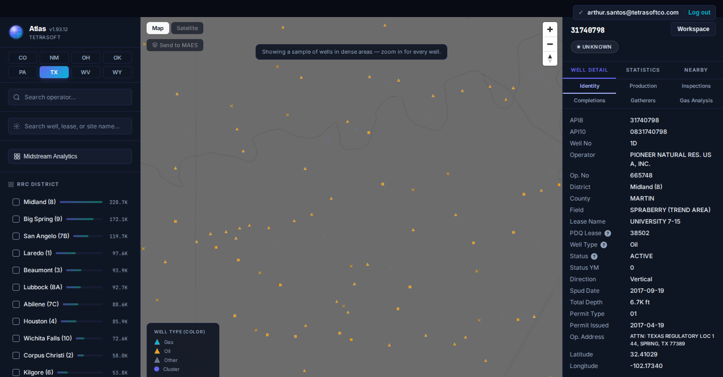
*The field name lives on the individual well record, not on a boundary layer [3]. This Martin County well reports SPRABERRY (TREND AREA) alongside its operator, lease, and status. *
If you are starting from a well number rather than a field name, API Well Number Lookup: What It Is and How to Read One walks through reading the identifier first. Colorado’s field names sit in the same records covered by Colorado Oil & Gas Map: Emissions and Enforcement Data and COGCC (Now ECMC) Oil & Gas Data, Cross-Linked and Faster Than the State Portal.
Frequently Asked Questions
Is there an official oil field boundary map?
Whether an agency publishes an official field boundary depends entirely on the state, and for most of the country the answer is no. Colorado publishes a field shapefile built by buffering wells grouped by field code [2]. Wyoming’s state geological survey publishes 1,380 field polygons built by a comparable model [4]. Texas publishes 22 GIS layers and not one of them is a field outline [5]. Commercial atlases draw shapes everywhere else, but those are interpretations rather than an agency record.
What is the largest oil field by well count?
Each state has its own answer, and they dominate their states very differently. Wattenberg holds about 28 percent of Colorado’s wells and the PRB Coal Bed field about 26 percent of Wyoming’s, against Spraberry’s 4 percent of Texas’s. No Texas field comes close to that share, because the state spreads its wells across 55,791 names.
Why do so many wells say Wildcat?
Wildcat marks a well drilled outside any established field, so it accumulates every exploratory well a state has ever permitted [1]. The designation is never retired as fields fill in around those wells, so the count only rises. Treat it as a null value rather than a place, and watch for the state-specific spelling, since Wyoming writes it as WC [4].
How do I find which field a well belongs to?
Open the well’s record and read its field name, which nearly every Colorado and Wyoming well carries and about seven in ten Texas wells do. Atlas shows it in the well detail panel next to the operator and status [3]. Searching by field name instead returns the whole set of wells sharing it [3].
How much does TetraSoft Atlas cost?
Atlas offers three plans, from individual analysts to large operator teams. All paid plans include a 7-day free trial, and canceling before day 7 costs nothing. For current plans and prices, see the Atlas pricing page.
Field names are the most-used and least-explained column in the well records. Atlas maps every well with its field attached, across eight states and expanding nationwide [3]. Start your free 7-day trial.
References
- Railroad Commission of Texas, Oil and Gas Glossary. https://webapps2.rrc.texas.gov/EWA/help/DP_gloss.htm
- Colorado Energy and Carbon Management Commission, COGCC_Fields shapefile metadata. https://ecmc.state.co.us/COGIS_Help/GIS_Help/Documents/COGCC_Fields.htm
- TetraSoft Atlas, oil and gas field and well dataset. https://tetrasoftco.com/atlas-landing.html#pricing
- Wyoming State Geological Survey, Oil and Gas Data_layers map service. https://portal.wsgs.wyo.gov/ags/rest/services/OilGas/Data_layers/MapServer
- Railroad Commission of Texas, Public GIS Viewer Data Sources Table. https://gis.rrc.texas.gov/gisviewer/GISViewer/docs/publicVeiwerDST.pdf
- Oklahoma Corporation Commission, Oil and Gas Data Files. https://oklahoma.gov/occ/divisions/oil-gas/oil-gas-data.html
Comments
0Share your thoughts. All comments are moderated before appearing.
No comments yet. Be the first to share your thoughts!