The RRC Wellbore Query is the Texas Railroad Commission well search that returns well records by API number, operator, lease, county, or district [1]. It is one of the Commission’s Online Research Queries, runs on its EWA system, and refreshes nightly [2]. Texas keeps about 1.21 million oil and gas wells on record, and the query reaches any of them by wellbore. Production is the one thing it will not hand you, and Texas reports production by lease rather than by individual well [3]. Every one of those wellbores also sits in TetraSoft Atlas, our subscription platform that attaches production, inspections, and gas analysis to each well [4].
Quick Answer: The RRC Wellbore Query returns Texas well identity records by API number, operator, lease, county, district, field, or drilling permit number [1]. It does not return production volumes, and Texas reports those by lease in the separate PDQ system [3]. Atlas maps Texas wellbores and attaches each well’s production history and inspection record [4].
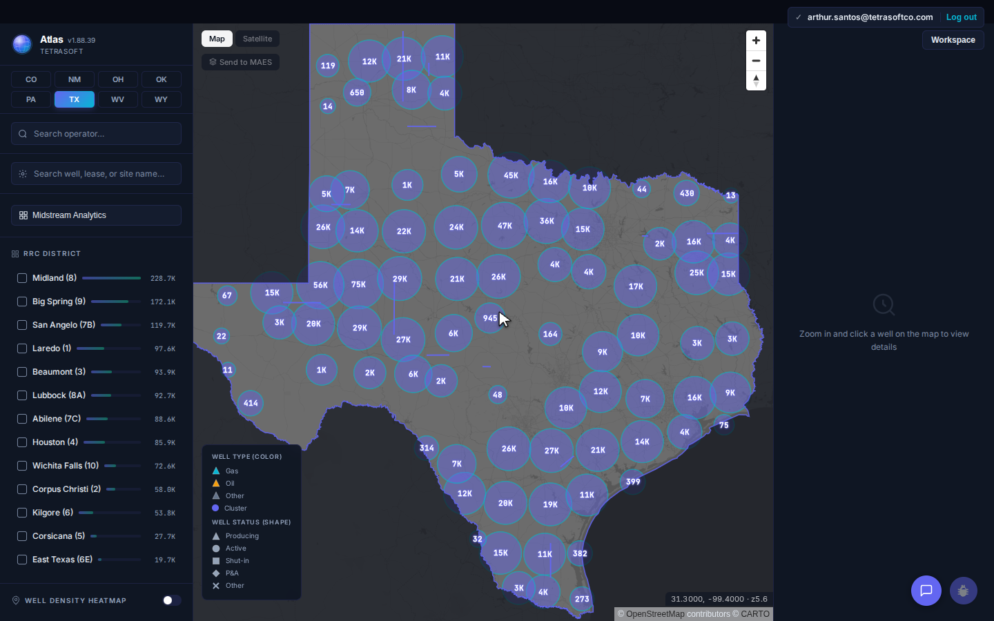
Texas wells grouped by RRC district, the same district codes the Wellbore Query form offers in its dropdown.
How to Run an RRC Wellbore Query
A Texas RRC well search starts here. Open the Wellbore Query form, choose oil or gas wells, enter one identifier, and submit [1]. The form opens with a “Choose One:” selector for Oil Wells, Gas Wells, or Both [1]. A second “Choose One:” selector at the bottom sets Current, Historical, or Both [1]. Leave that on Both when you do not know whether a well is still active.
The search fields themselves are narrow and specific. “API Unique No.” takes the Texas well number in a structured box already prefixed with 42, the state code for Texas [1]. “Oil Lease No./Gas Well ID No.”, “Field(s)”, “Operator(s)”, and “Drilling Permit No.” each take typed entries [1]. “District:”, “County:”, and “Type Well:” are dropdowns, the last carrying 25 well-type options such as PRODUCING, SHUT IN, and ABANDONED [1].
Which Field Finds a Well Fastest
The API number finds one wellbore with no ambiguity, so start there whenever you have it. An operator or field name returns every matching wellbore, which is useful for a portfolio sweep and slow for a single well. The district dropdown lists 13 districts, running 01 through 06 and 08 through 10, plus 6E, 7B, 7C, and 8A [1]. Pair a district with a well type when you want a county-scale list instead of one record.
If you are unsure how to read the API number before you type it, the API well number lookup guide breaks the digits down.
What the Wellbore Query Returns, and What It Leaves Out
The Wellbore Query returns a wellbore’s identity and status, and it stops before production volumes [1]. That gap is structural rather than an oversight in the tool. The Railroad Commission states the rule plainly: “In Texas, production is reported by each oil and gas lease rather than individual well.” [3] Production lives in the separate PDQ system, which covers January 1993 to present [3].
The oil and gas cases differ, and the difference matters. An oil lease can carry many wells, and its reported monthly production covers all of them together [3]. The Commission states that gas leases contain one gas well per lease [3].
Read the well count on the record anyway, since a gas-typed wellbore can still sit on a lease carrying several wells. The Wellbore Query’s own field label carries that split, reading “Oil Lease No./Gas Well ID No.” in a single box [1].
Why Lease-Level Production Trips Up Well-Level Analysis
Attributing lease production to one wellbore overstates that well whenever the lease holds more than one. Take the UNIVERSITY 54-24 well in Schleicher County, operated by UPP OPERATING, LLC, which Atlas keys as 0141332528 (RRC district 01 plus the well number, not an API-10). That wellbore sits on PDQ lease 24304, and the lease carries nine wells. Any per-well figure drawn from it is a share of a nine-well total, not a measured wellbore volume.
A nine-well lease hiding behind one API number is the kind of detail that survives an entire analysis unnoticed. Check the lease well count before you treat any Texas production figure as one well’s output.
How to Pull Texas RRC Production Data by Lease, County, or Operator
For Texas RRC production data, the Commission’s own tool is the Production Data Query (PDQ), not the Wellbore Query [3]. An RRC production query in PDQ searches by lease, field, operator, district, or county, from January 1993 to present [3]. Operators file each month’s report by the end of the following month, so online figures run about two months behind [3]. For Texas oil production by county, the Commission also posts a monthly Production by County Ranking [6].
Atlas carries the same PDQ lease volumes and divides each lease total by the number of wells on that lease. Each wellbore record shows its PDQ lease number and loads that allocated monthly history back to 1993. The statewide analysis view ranks Texas counties and operators by gas produced, with liquids alongside. Compare plans and start a trial at TetraSoft Atlas.
Where the RRC Wellbore Query Stops Short
The Wellbore Query answers one question in one system, separate from the Commission’s public GIS viewer, with no map and no bulk download [2]. The Commission warns that its query data is “NOT intended to be used as an authoritative public record” and has “no legal force or effect.” [2] The Commission blocks scraping outright, ending the session of any user it detects pulling data with an automated tool [2].
Atlas takes the same public RRC records and connects them on one Texas map [4]. A wellbore opens with its identity, production history, inspections, completions, and gas analysis on one record [4]. The WELDER MINNIE S. well carries 34 years of production, 32 inspections, and a 1978 gas composition analysis in that single view. You can open the same Texas map on a free trial and check a wellbore yourself [4].
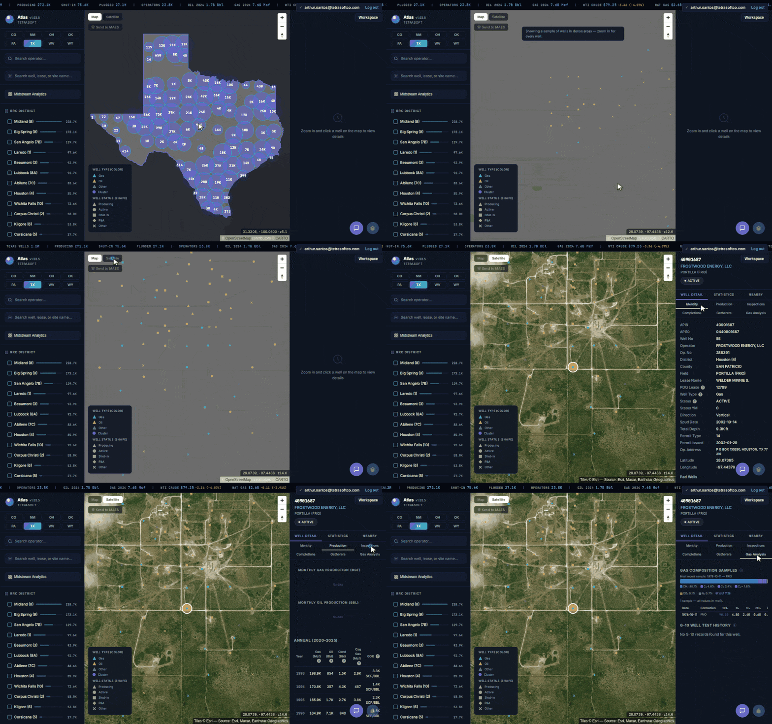
Zooming from statewide clusters to one pad, then reading that wellbore’s record tab by tab, gas composition included.
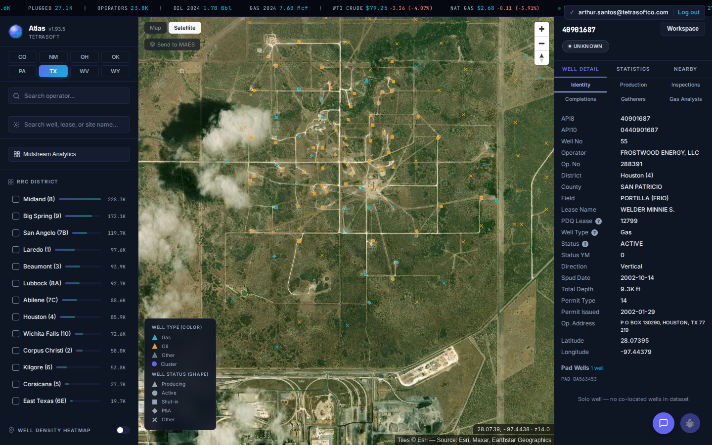
One wellbore’s record, with its PDQ lease number and permit dates on the same panel as its production and inspection tabs.
Each Tool Wins on Something Different
The two tools overlap on identity and diverge nearly everywhere else.
| Capability | RRC Wellbore Query | Atlas |
|---|---|---|
| Well identity by API, operator, lease | Yes | Yes |
| Cost and account | Free, no login | Subscription after a 7-day trial |
| Live agency source of record | Yes | Processed copy, refreshed monthly |
| Results on a map | No | Yes |
| Production attached to the well | Separate PDQ query, lease-level | On the record, allocated from the lease |
| Inspections and completions | Separate queries | On the same record |
| Gas analysis | Separate query | On the same record |
| Air-permit and emissions data | Not an RRC dataset | TCEQ sites and EPA GHGRP |
| Pipelines and gas plants | Separate queries | Mapped statewide |
| Whole-state view | Automated access blocked | Every wellbore at once |
| Wells outside Texas | No | Seven more states |
The comparison reflects the Commission’s publicly documented query behavior, checked in July 2026. The Commission wins the top two rows outright, and that matters for anything official. Go to the Commission directly when the record has to come from the source.
One Agency’s Query Cannot Reach Air or Emissions Data
A Texas well’s public record is split across several agencies, and the Commission holds only its own part. Atlas joins the RRC well, production, and pipeline files with RRC gas well tests and USGS gas analyses [4]. EPA FRS and GHGRP emissions and TCEQ air-permit sites sit on top of that [4]. Texas carries 667 facilities reporting to the EPA Greenhouse Gas Reporting Program across 2016 to 2023, with CO2e by year and segment. No RRC research query returns any of that.
Scale is the other half of the gap. Because the Commission terminates automated sessions, a portfolio-wide question cannot be assembled from the free tools at all. Atlas answers the same question across the state at once: 23,776 operators, 673,351 wells with production history, and 1,386 gas plants. Lab gas analyses reach 3,069 Texas wells, which is where H2S and heating value actually live.
Texas is one of eight states carrying this view. Oklahoma’s map is walked through in the OCC Oklahoma oil and gas guide, and New Mexico’s in the NMOCD well search guide.
Frequently Asked Questions
What is the RRC Wellbore Query?
The RRC Wellbore Query is the Commission’s record-level search for Texas wellbores [1]. Its results are tabular, and they key to the wellbore rather than to a lease or a permit [1]. The Commission publishes 28 oil and gas queries in that system, and the Wellbore Query is one of them [2]. Which one you want follows from the question: the Completions Query for what was drilled and completed, the Drilling Permit (W-1) Query for a permit, the Production Data Query System (PDQ) for volumes, the Field Rules Query for the rules governing a field, the Oil & Gas Imaged Records Menu for the filed paperwork, and the Organization (P-5) Query for the operator of record [2]. Most of them are updated daily [5].
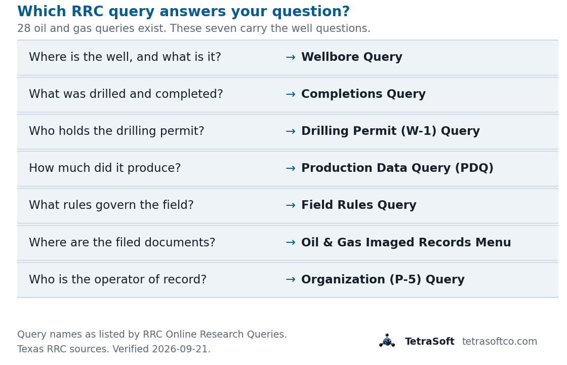
Seven of the Commission’s 28 oil and gas queries carry almost every well question [2]. Each answers a different question, which is why one lookup rarely finishes the job.
Can I get one well’s production from the Wellbore Query?
No, the query returns identity and status rather than volumes [1]. Go to the PDQ system for production, and search it by lease rather than by wellbore [3]. Converting that lease total to a per-well figure needs the count of wells on the lease. Budget for the extra step whenever an analysis is keyed to API numbers.
Is Wellbore Query data official enough to file against?
The Commission says its query datasets are not an authoritative public record and carry no legal force or effect [2]. Treat query output as a research starting point rather than a filing source. Request the official record from the Commission when a filing or a transaction depends on it.
Why does my Wellbore Query search return nothing?
An over-narrow filter combination is the usual cause of an empty result. Check that the “Choose One:” period selector is set to Both rather than Current. Confirm the well type dropdown is not pinned to a status the well no longer holds. Clear every field except the API number and search again.
How much does TetraSoft Atlas cost?
Atlas offers three plans, from individual analysts to large operator teams [4]. All paid plans include a 7-day free trial, and cancelling before day 7 costs nothing [4]. For current plans and prices, see the Atlas pricing page [4].
The Wellbore Query does its job well, and its job ends at the wellbore’s identity. Atlas carries that wellbore onto a map with its production history and inspection record already joined [4]. Start your free 7-day trial.
This post is for informational purposes only and does not constitute legal or compliance advice. Consult qualified legal counsel or a compliance professional for guidance specific to your operations and jurisdiction.
References
- Railroad Commission of Texas (RRC), Wellbore Query, RRC Online Research Queries. https://webapps2.rrc.texas.gov/EWA/wellboreQueryAction.do
- Railroad Commission of Texas (RRC), RRC Online Research Queries. https://www.rrc.texas.gov/resource-center/research/research-queries/
- Railroad Commission of Texas (RRC), Production Data Query System (PDQ) FAQs. https://www.rrc.texas.gov/about-us/faqs/oil-gas-faq/production-data-query-system-faqs/
- TetraSoft Atlas, Texas oil and gas dataset and product features. https://tetrasoftco.com/atlas-landing.html#pricing
- Railroad Commission of Texas (RRC), About Oil & Gas Data Queries. https://www.rrc.texas.gov/resource-center/research/research-queries/about-oil-gas-data-queries/
- Railroad Commission of Texas (RRC), Oil & Gas Production Data. https://www.rrc.texas.gov/oil-and-gas/research-and-statistics/production-data/
Comments
0Share your thoughts. All comments are moderated before appearing.
No comments yet. Be the first to share your thoughts!