A well log is the measurement of physical quantities down a wellbore, recorded against depth on wireline or while drilling [1]. Logs are public records in the major producing states. Each state’s regulator or geological survey keeps its own repository, so no single national place exists to look one up [2]. Every successful lookup therefore follows two steps: identify the well by its API number, then pull its file from that state’s system.
The API well number works across every state because each issues it from the same national scheme [3]. TetraSoft Atlas, our subscription platform that indexes 2.7 million wells across eight states, resolves the identity step from a name, operator or county [4].
Quick Answer: Well logs live in state repositories, not a national database, and each lookup is two steps [2]. First, identify the well by its API number. Second, open that state’s log repository, from Colorado’s COGIS to Pennsylvania’s EDWIN, and retrieve the file [5]. TetraSoft Atlas handles the first step: one search across eight states resolves a well and its API number from name, operator or county [4].
A Well Log Lookup Runs on the API Well Number
The lookup fails or succeeds at the identity step, before any log repository is even opened. State systems index well files by API number [3].
The identifier runs 10 to 14 digits, with the first two encoding the state and the next three the county [3]. Names do not travel: the same operator appears under different spellings in different states, and well names repeat. Reading the number itself is covered in API Well Number Lookup: What It Is and How to Read One.
Working from a lease document, a landowner file or an old map, you often have everything except the number. That is the moment the lookup stalls for most people, and it is entirely avoidable. A well database that searches by name, operator, county or location returns the well with its API number attached [4]. With the number in hand, the state repository lookup is a form fill.
Every Well Log Lookup Follows the Same Two Steps
Every lookup resolves the same way: identify the well by its API number, then open the repository the number’s state prefix names. The diagram traces that funnel from whatever you start with.
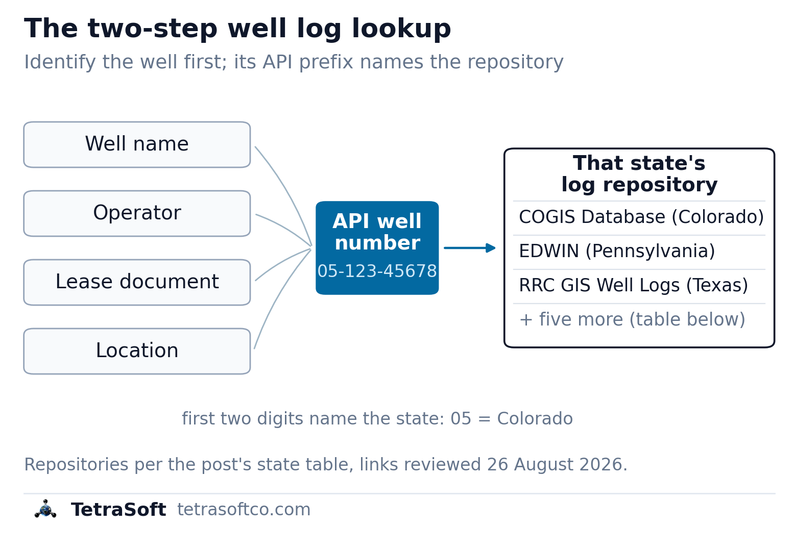
Any starting point resolves to the API number first; its state prefix then names the repository that holds the log [3].
Where Each State Keeps Its Well Logs
Eight major producing states, eight repositories, and no two work alike [5]. Some sit inside the oil and gas regulator, others inside the state geological survey [5].
| State | Log repository | Run by |
|---|---|---|
| Colorado | COGIS Database | ECMC, the oil and gas regulator |
| Texas | RRC well records, RRC GIS well logs and the UT-BEG Geophysical Log Facility | regulator and university survey |
| Oklahoma | OCC oil and gas data | OCC, the regulator |
| Ohio | ODNR Well Locator well documents | ODNR, the regulator |
| Pennsylvania | EDWIN | DCNR, the state geological survey |
| West Virginia | WVGES well records | the state geological survey |
| New Mexico | OCD well-file imaging | OCD, the regulator |
| Wyoming | WOGCC well search | WOGCC, the regulator |
*Each link is the repository’s own entry point, reviewed 2026-08-26; the USGS Core Research Center keeps a directory of every state’s well data for states beyond these eight. *
The split between regulators and geological surveys catches people out. Pennsylvania files its logs with the state geological survey rather than with the agency that permits the wells [5]. West Virginia does the same, at WVGES [5].
Texas splits the job too: the RRC holds the regulatory well records while the University of Texas Bureau of Economic Geology maintains log collections [5]. The RRC’s well-log profile carries images of the logs it has received since July 2004 [5]. Older logs are the side the university survey covers. Knowing which door to knock on is half the lookup.
What Comes Back Is Not Always a Digital Log
Finding the repository is half the job, because repositories do not all hand back the same thing.
The digital form is LAS, the Log ASCII Standard, a specification for storing and distributing digital well log data [6]. The Canadian Well Logging Society defined LAS and still maintains it; LAS 2.0 is the most used version [6]. A LAS file loads straight into log analysis software.
Much of what a state serves is a scanned page instead. A scan can be read by eye but not computed against until someone digitises the curves. Ask which form a repository holds before planning work that assumes the digital one.
Wells in federal waters sit outside all of this. The Bureau of Ocean Energy Management publishes well data and an API lookup for the federal offshore [7]. Its public well pages serve headers, surveys and reports rather than log images [7].
Which Repository Holds Your Well’s Logs?
The API number’s state prefix identifies the correct repository [3]. The tool below runs that routing for you: pick a state, or paste an API number and let its prefix pick the state [4]. It returns the repository that holds the logs, who runs it, and what you need in hand [4].
TetraSoft Atlas Finds the Well Behind the Log
TetraSoft Atlas solves the identity step at scale: one search across 2.7 million wells in eight states, by operator, county, well name or API number [4]. Each well opens with its identity, status, production history, gas composition, emissions and enforcement record in one panel [4]. For the log itself, the record’s API number is your ticket into the state repository from the table above.
The eight states in TetraSoft Atlas produced 68 percent of US crude oil and 83 percent of US marketed natural gas in 2025 [8]. Atlas is self-serve, with no sales call: you sign up and start a 7-day trial with no credit card [5].
One honest boundary: Atlas does not host the raw log files [4]. The scanned curves and LAS files stay with the state systems, and that is where a log lookup should end. What Atlas removes is everything before that: finding the well, confirming its identity, and reading its history first.
Working a list of wells rather than one? The same search resolves an operator’s full position across all eight states at once, which turns a week of portal visits into an afternoon [4]. The eight state registers behind it are walked in Oil and Gas Well Map: 2.7M Wells Across Eight States.
Frequently Asked Questions
What is a well log?
A well log records physical quantities down a wellbore against depth [1]. Gamma ray, resistivity and porosity curves are the classic wireline examples. Operators file the results with the state, and the scanned or digital file is what a lookup retrieves [5].
Are well logs public records?
Yes: the major producing states serve well logs through public repositories run by their regulator or geological survey [5]. A recently drilled well’s log may not be public yet, because a repository can only serve what its agency has released. A log you cannot find today is worth re-checking after the record catches up.
Can I look up a well log by API number?
Yes, and it is the most reliable route. The API number’s first two digits name the state, which also names the repository to search [3]. TetraSoft Atlas resolves that lookup across eight states from an operator, a name or a county [4].
Why is there no single national well log database?
Because onshore drilling is regulated state by state, and each regulator or survey built its own repository. The USGS Core Research Center’s directory of state well data is the closest thing to a national index [2]. Private aggregators assemble national views on top of the state files, trading currency for breadth.
A log lookup is an identity problem wearing a paperwork costume. TetraSoft Atlas resolves the identity across eight states and hands you the API number; the state repository hands you the log [4]. Start your free 7-day trial.
References
- Asquith, G. & Krygowski, D., Basic Well Log Analysis, AAPG Methods in Exploration No. 16, 2nd ed., 2004.
- American Petroleum Institute, Bulletin D12A well numbering standard (1968; 1979 revision), now maintained by the Professional Petroleum Data Management (PPDM) Association.
- U.S. Geological Survey Core Research Center, Links to State Well Data, reviewed 2026-08-26. https://www.usgs.gov/core-research-center/links-state-well-data
- State oil and gas well-log repositories (Colorado ECMC COGIS; Wyoming WOGCC; Texas RRC records and UT-BEG log collections; Oklahoma OCC; Ohio ODNR; Pennsylvania DCNR EDWIN; West Virginia WVGES; New Mexico OCD well-file imaging), reviewed 2026-08-26.
- TetraSoft Atlas, multi-state oil and gas dataset and product features. https://tetrasoftco.com/atlas-landing.html#pricing
- U.S. Geological Survey, Log ASCII Standard (LAS) format, reviewed 2026-08-26. https://www.usgs.gov/programs/national-geological-and-geophysical-data-preservation-program/las-format
- Bureau of Ocean Energy Management, Well Information for the federal offshore, reviewed 2026-08-26. https://www.data.boem.gov/Main/Well.aspx
- U.S. Energy Information Administration, crude oil field production and natural gas marketed production by state, annual 2025, accessed 23 September 2026. https://www.eia.gov/dnav/pet/pet_crd_crpdn_adc_mbbl_a.htm; https://www.eia.gov/dnav/ng/ng_prod_sum_a_EPG0_VGM_mmcf_a.htm
Well log router
Where do this well’s logs live?
Pick a state, or paste an API well number and let its first two digits pick the state for you.
Logs for Colorado live at
COGIS Database
Run by ECMC, the oil and gas regulator
Open the repositoryThat doesn’t parse as an API well number yet. It starts with two digits naming the state, like 05 for Colorado or 42 for Texas. Keep typing, or pick a state above.
What you need in hand
The API well number, the identifier every state system resolves.
Well files and scanned documents resolve from the well record.
Eight covered states route to their repository’s own entry point; any other valid prefix routes to the USGS Core Research Center directory of state well data. Links reviewed 26 August 2026. Nothing leaves your browser.
Comments
0Share your thoughts. All comments are moderated before appearing.
No comments yet. Be the first to share your thoughts!