Wyoming keeps about 68,700 oil and gas wells on record with the Wyoming Oil and Gas Conservation Commission. The WOGCC is the state agency that permits those wells and collects their production reports [1]. Searching for one well means choosing among the WOGCC Data Explorer, the agency’s WellFinder app, and a separate Wyoming State Geological Survey map service. Each answers part of the question, so building a full picture of a single well usually takes more than one lookup. Every one of those wells also sits in TetraSoft Atlas, a subscription data platform, searchable by well name or operator and filtered by county [2].
Quick Answer: Wyoming has about 68,700 oil and gas wells on WOGCC record across all 23 counties, roughly 28,000 of them producing. TetraSoft Atlas maps them on one screen with production history, well status, and gas analysis attached to each one [2].
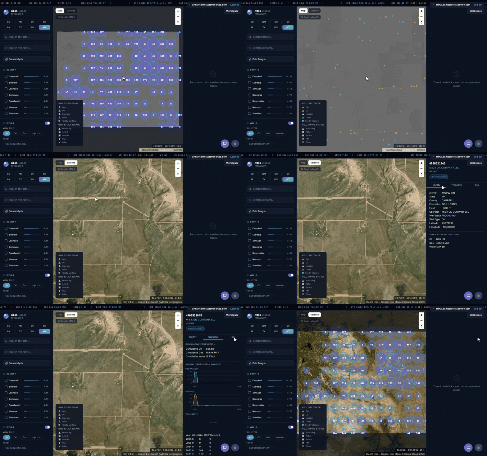
Every Wyoming well on one map, from statewide clusters down to a single well’s status, production, and gas composition. [2]
Search Every Wyoming Well and Open Its Full Record
For a Wyoming oil and gas well search, one search box returns any well without switching between state systems [2]. You search by well name or operator, or filter by county, and the result opens with its record attached [2]. About 978 distinct operators appear across the Wyoming dataset, from large basin operators to single-well owners.
The Wyoming oil well map clusters wells statewide, then resolves to individual wells as you zoom [2]. Wyoming does not drill evenly. Campbell County alone carries about 18,300 wells, with Sublette at roughly 8,000 and Johnson at about 7,600. That concentration is why a statewide list is a poor starting point for Powder River Basin work.
Satellite imagery sits behind the map, so a well’s pad and access roads are visible at the same zoom [2]. If you are starting from a number rather than a place, the API well number lookup guide explains how to read those digits.
What the WOGCC Record Shows for Each Well
The WOGCC record behind a Wyoming well covers its identity, its status, and its production history [1]. Identity carries the API number, operator, field, formation, county, and coordinates [1]. Status matters more in Wyoming than the raw well count suggests.
About 28,000 WOGCC wells are producing while roughly 17,200 sit shut in, alongside about 8,200 permitted and 5,100 plugged. A shut-in well is capable of production but not currently flowing, so it still carries a full history [1]. Reading a count of Wyoming wells as a count of active wells overstates activity by a wide margin.
Production accrues month by month and reaches back decades [1]. Atlas carries about 3.96 million monthly production records for Wyoming, with annual history running from 1978 to the present. A well’s full curve sits on the same screen as its status and operator [2].
Wells are not the only Wyoming records on the map [2]. Atlas also carries about 12,100 Wyoming facilities and roughly 36,500 equipment records alongside them. Those sit in the same view as the wells, so a tank battery or compressor is visible next to the wells it serves [2]. For emissions work, that adjacency is usually the point rather than a convenience.
The record also reaches past what the WOGCC itself publishes. Where a gas sample exists, Atlas shows its composition beside the WOGCC record [3]. The breakdown covers methane, heavier hydrocarbons, nitrogen, carbon dioxide, and helium, with a heating value per cubic foot [3].
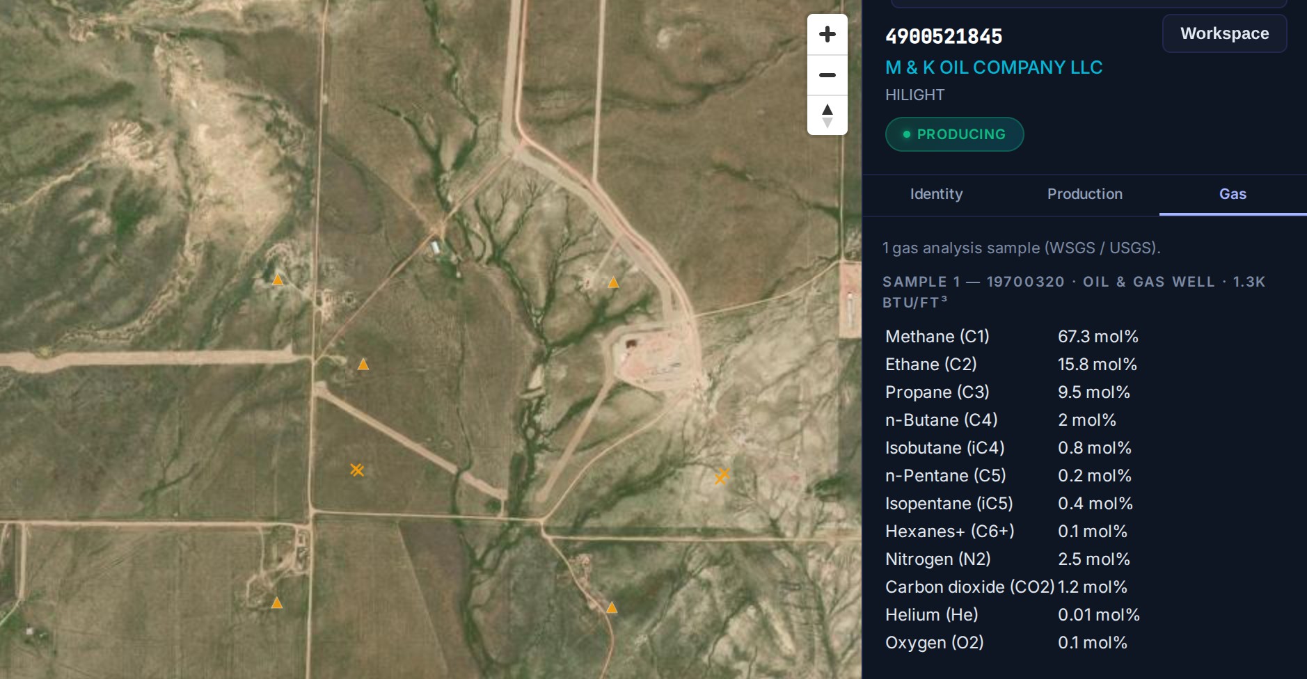
A Wyoming well’s gas analysis sits on the same screen as its WOGCC identity and production record. [2]
That sample is the part worth pausing on. The Campbell County well above reads 67.3 mol percent methane with 15.8 percent ethane and 9.5 percent propane [3]. Gas that rich in heavier hydrocarbons behaves differently in processing than dry gas does.
WOGCC Production Data: Monthly Reports, Charted by Year
Wyoming operators file a report of all oil, water and gas production for each month [4]. Each report is due by the last calendar day of the following month, under Chapter 3, Section 13 of the commission’s rules [4].
For Wyoming oil well production, Atlas sums each well’s WOGCC monthly reports across its reservoirs [2]. The Production tab shows cumulative oil, gas and water, then charts each year’s volumes with a table beneath [2]. Start a free trial from the Atlas page to open any Wyoming well’s production.
Why One WOGCC Lookup Is Rarely Enough
The commission keeps its well data across several separate access points. A map service answers where a well sits, and a data query answers what it produced. Neither connects a well’s location to its production history and gas analysis in a single view.
Wyoming compounds that split with geography. Campbell County sits in the Powder River Basin, while Sublette County spans the Greater Green River Basin and the Overthrust Belt [3]. Their well centroids lie more than 200 miles apart. An operator working both is reconciling two areas through the same set of narrow lookups.
The commission’s own systems still win on one dimension. Wyoming drilling permits and status changes appear in WOGCC filings first, before a monthly refresh carries them downstream. For a same-day filing check, go to the commission.
Atlas removes the reconcile step for everything else [2]. One search resolves the well, and its location, status, production, and gas analysis open together [2]. Wyoming’s midstream picture sits on the same map, and the natural gas pipeline map covers how that layer works.
Frequently Asked Questions
What is a WOGCC well search?
A WOGCC well search finds a specific Wyoming oil or gas well in the commission’s public records [1]. It usually starts from an API number, a well name, or an operator name [1]. The commission exposes this through its data query and mapping tools, while Atlas answers the same search on one map [2].
Can I search Wyoming wells by API number?
Yes, an API number is the most direct way to find one Wyoming well [2]. Wyoming wells carry the state API prefix 49, followed by a county code and a unique well number [1]. In Atlas, you find the well by its name or operator, and its record shows the API number [2].
Which Wyoming counties hold the most wells?
Campbell County holds the most by a wide margin, at roughly 18,300 of the state’s wells. Sublette, Johnson, Converse, and Sweetwater follow, each between about 4,800 and 8,000. The dataset spans all 23 Wyoming counties.
Do Wyoming wells include gas composition data?
Some do, drawn from Wyoming State Geological Survey and USGS analyses rather than from the WOGCC [3]. Coverage is thin, at roughly 1,200 samples statewide. Treat an absent sample as unmeasured rather than as dry gas.
How current is the Wyoming well data?
The Wyoming dataset refreshes monthly from WOGCC records [2]. Production history runs from 1978 to the present, so a well’s early years remain visible alongside its recent months. Newly permitted wells appear with a permitted status before any production is reported against them.
A Wyoming well search should not mean three state systems and a manual reconcile. Atlas puts every Wyoming well and its status, production, and gas analysis on one map, refreshed monthly from WOGCC records [2]. Start your free 7-day trial.
References
- Wyoming Oil and Gas Conservation Commission (WOGCC) public well, production, and completion records.
- TetraSoft Atlas, Wyoming oil and gas dataset and product features. https://tetrasoftco.com/atlas-landing.html#pricing
- Wyoming State Geological Survey (WSGS) and USGS gas analysis samples, surfaced per well in TetraSoft Atlas.
- Wyoming Administrative Code, 055-3 Wyo. Code R. § 3-13, Operator’s Monthly Report of Wells, accessed September 28, 2026. https://www.law.cornell.edu/regulations/wyoming/055-3-Wyo-Code-R-SS-3-13
Comments
0Share your thoughts. All comments are moderated before appearing.
No comments yet. Be the first to share your thoughts!