Buying oil and gas wells means buying their history with the regulator. Texas is this guide’s worked example for well transfers, because it is the largest US oil producer [1]. A Texas buyer files Form P-4, the state regulator’s operator certificate, and certifies on it that it is responsible for plugging the wells [2]. From P-4 approval, idle wells and any uncorrected condition become the buyer’s compliance problem; the form does not assign the seller’s past penalties.
When operators cannot pay, the public often does: by September 30, 2025, Interior had awarded 26 states $1.54 billion in State Program orphaned well grants [3]. An oil and gas due diligence checklist is the list of records a buyer reviews before acquiring wells, leases or an operating company. It confirms what is being sold and which liabilities come with it. It is run by the buyer’s side: acquisition and divestiture (A&D) teams, landmen, private equity and mineral buyers, and lenders.
It has three workstreams: legal (title and contracts), technical (reserves and well condition) and regulatory. The seller’s data room holds most of the first two, while the regulatory record sits with state and federal agencies and rarely arrives complete. Most of these records sit with each state, so a target in Texas, Oklahoma, New Mexico and Colorado means a separate search in each state.
This checklist covers that regulatory record, for buyers, landmen and lenders who have never pulled a state well file. It lists ten agency records in the order an A&D team pulls them, then shows how to read violations, spills and emissions. It then shows which records TetraSoft Atlas, our subscription platform for state oil and gas records, carries in each state. It ends on plugging and injection, which outlast the closing.
Quick Answer: An oil and gas due diligence checklist for the regulatory record pulls ten agency records in every state where the target has wells. Read each violation as filed, and check whether it is still an allegation or a final order. TetraSoft Atlas carries many of these records for eight states that produced 68% of US crude oil and 83% of US marketed gas in 2025 [1].
What Goes on an Oil and Gas Due Diligence Checklist?
The regulatory part of an oil and gas due diligence checklist is ten agency records, each answering one buyer question. The table lists them in pull order, with the agency that holds each one on state and private land. The buyer’s land or A&D team pulls them, with the deal’s attorneys and engineers. Regulators keep the records but do not run the checklist, and a lender may ask to see the same list.
| # | Record | What it answers for the buyer | Who holds it |
|---|---|---|---|
| 1 | Operator | Who answers to the state for these wells? | State oil and gas regulator |
| 2 | Wells | Which wells, and what status is each in? | State oil and gas regulator |
| 3 | Production | Did the volumes in the offering memo get reported? | State regulator; in Oklahoma, the Tax Commission |
| 4 | Permits | What is drilled, permitted or pending? | State oil and gas regulator |
| 5 | Spills | What has been released, and was it cleaned up? | State regulator or environmental agency; for oil reaching water, the federal National Response Center (NRC) |
| 6 | Inspections | How has the state found the sites on the ground? | State oil and gas regulator |
| 7 | Violations and enforcement | What was alleged, and how was it resolved? | State regulator; for federal programs, ECHO, the compliance database of the Environmental Protection Agency (EPA), the federal environmental regulator |
| 8 | Emissions | What does the operator report emitting? | EPA’s Greenhouse Gas Reporting Program (GHGRP), its annual emissions reporting rule for large facilities; state inventories such as Colorado’s ONGAEIR, its annual oil and gas emissions inventory |
| 9 | Plugging liability | Which idle wells will need plugging, and what bond covers them? | State oil and gas regulator; the Bureau of Land Management (BLM), the federal agency for federal and Indian leases |
| 10 | Injection | Does the operator own or feed disposal wells? | The state with primacy for underground injection control (UIC), the permit program for injection wells, or EPA |
Records 1 to 4 confirm what you are buying, and records 5 to 8 show how it has been run. Records 9 and 10, with any spill cleanup still open, price what outlasts the closing. Production is the first record to test against the seller’s numbers.
Oklahoma production is published on a lease basis: the Oklahoma Tax Commission reports each lease’s production volumes by its Production Unit Number (PUN) [4]. Its Gross Production page links a search for PUNs by county or legal description [4].
On federal and Indian leases, a second regulator keeps records too. The Bureau of Land Management has performed over 25,000 inspections a year since fiscal 2015 on oil and gas lease and well cases [5]. It records noncompliance as an Incident of Noncompliance (INC) [5].
Read Violations and Spills: What to Check and Where
Violations and spills are where a target’s operating record is visible; an uncorrected condition on a transferred well can become the buyer’s to fix. Read each one as filed: Colorado’s notices of alleged violation are allegations until resolved, while a BLM INC records a finding of noncompliance.
Colorado’s oil and gas regulator is the Energy and Carbon Management Commission (ECMC) [6]. Its Notice of Alleged Violation (NOAV) means the ECMC Director has reasonable cause to believe the operator broke a rule, order, permit or the Act [6]. The operator may negotiate an Administrative Order by Consent instead of appearing at a hearing [6].
Each state publishes these records in its own system. Texas lists its enforcement programs on the Railroad Commission’s compliance and enforcement page. Pennsylvania publishes an Oil and Gas Compliance report you can filter by operator.
Colorado’s records hang off each facility in the ECMC facility search. For federal air, water and waste programs, EPA’s Enforcement and Compliance History Online (ECHO) database searches facilities by enforcement and compliance activity [7].
Four checks turn the records into findings a deal team can price.
- Status: is each item still an allegation, a consent order or a final order, and is any penalty unpaid?
- Open items: list the violations and spills not yet closed, with the agency, date and well, because these are the ones a buyer can inherit.
- Repeats: count closed items too, since the same violation on the same wells year after year shows how the assets are run.
- Spill cleanup: for each release, note the volume and whether the agency has closed the remediation.
Write each finding the same neutral way: the agency, the record type, the date and the status as filed.
In TetraSoft Atlas, these records sit on the well or site you click [8]. A Pennsylvania well’s Compliance tab lists its inspections, violations, enforcement and penalties [8]. Texas inspections show the violated rule and the Railroad Commission’s latest enforcement action, most often a Notice of Violation [8]. A Colorado site’s Enforcement tab lists its NOAVs and spills [8].
Atlas also maps spills in New Mexico and Wyoming, and its Ohio inspections flag any violation found [8]. The open-items list starts from one map instead of a separate system per agency.
Emissions Records Depend on Size and State
Emissions reports exist where a reporting program, an air permit or a federal air standard reaches the target’s facilities, and each sets its own scope. Oil and gas facilities emitting 25,000 metric tons of CO2e a year or more report under Subpart W of EPA’s Greenhouse Gas Reporting Program [9]. Subpart W is the program’s section for petroleum and natural gas systems, in Part 98 of Title 40 of the Code of Federal Regulations [10]. For onshore production and for gathering and boosting, all of one operator’s equipment in one hydrocarbon basin counts as a single facility [10].
EPA’s proposal to end most GHGRP reporting and suspend remaining Subpart W segments until 2034 is not final; 2025 reports are due March 10, 2027. The Subpart W Proposed Rule: Is GHGRP Reporting Still Required? guide tracks what still applies.
State inventories fill the gap below the federal threshold in some states. Colorado is the clearest case. Colorado operators file their Oil and Natural Gas Annual Emission Inventory Reporting (ONGAEIR) reports by June 30 each year, under Regulation 7 [11]. In Atlas, Colorado is the one state whose emissions come from a state inventory; the other six with emissions show GHGRP facilities [12].
Run the Checklist State by State in TetraSoft Atlas
TetraSoft Atlas puts the checklist records it carries for eight states on one map, where each regulator keeps them in a separate system [12]. Those eight states produced 3.40 of 4.99 billion barrels of US crude oil (68%) and 35.8 of 43.2 Tcf of marketed gas (83%) in 2025 [1]. We plan to expand Atlas to every US state [13].
Filter by operator in any of the eight states, and in Colorado the filter narrows the sites on the map [12]. Atlas is scheduled to refresh every state at least monthly, and Colorado filings, including NOAVs, are re-pulled weekly; a state’s data can lag its schedule [13].
Which Records Does TetraSoft Atlas Carry in Each State?
TetraSoft Atlas carries operator and well status in all eight states, production in all but Oklahoma, and violation records in Texas, Colorado, Pennsylvania and Ohio [12]. The table shows where each record sits, as read from the platform on October 27, 2026 [8]. Its columns use postal codes: Texas (TX), New Mexico (NM), Oklahoma (OK), Colorado (CO), Wyoming (WY), Pennsylvania (PA), West Virginia (WV) and Ohio (OH).
The orphan row names each list’s source, usually the state’s oil and gas regulator, such as the Railroad Commission of Texas (RRC). New Mexico’s is the Oil Conservation Division (OCD), Oklahoma’s the Corporation Commission (OCC) and Wyoming’s the Oil and Gas Conservation Commission (WOGCC). Pennsylvania’s is the Department of Environmental Protection (DEP) and Ohio’s the Department of Natural Resources (ODNR). Colorado’s list comes from the US Geological Survey (USGS), the federal science agency, in a 2022 dataset whose Colorado rows date from July 2019 [8].
| Record | TX | NM | OK | CO | WY | PA | WV | OH |
|---|---|---|---|---|---|---|---|---|
| Operator and wells | Yes | Yes | Yes | Yes | Yes | Yes | Yes | Yes |
| Production | Monthly, lease-allocated | Monthly | No | Monthly, per site | Monthly | Monthly | Monthly | Annual |
| Permits | Well panel and permit layer | Lifecycle tab | Permits tab and layer | Permit list | Well panel | Permit number and date | No | Permit date |
| Spills | No | Spills tab and layer | Incidents tab | Site enforcement tab | Spills layer | No | No | No |
| Inspections | Yes | No | No | No | No | Yes | No | Yes |
| Violations and enforcement | Violations and enforcement actions on inspections | No | No | NOAVs | No | Violations, enforcement, penalties | No | Violations flagged on inspections |
| Emissions | GHGRP | No | GHGRP | ONGAEIR | GHGRP | GHGRP | GHGRP | GHGRP |
| Orphan wells nearby | RRC orphan list | OCD orphan list | OCC orphan list | USGS 2022 dataset (COGCC 2019 rows) | WOGCC list | DEP orphan and abandoned wells | No | ODNR program list |
| Plugging exposure estimate | Yes | No | No | No | No | Yes | No | Yes |
| Injection wells | Injection tab | Injection tab | UIC layers, injection tab with monthly volumes | UIC layer | UIC layer, injection tab | UIC layer | UIC layer | No |
Texas production in Atlas is the lease total split evenly across the lease’s wells, because the Railroad Commission records production by lease [12]. A gas lease holds one well, so the split matters on oil leases with several wells [14]. On a lease with several wells, each well’s figure is an allocation, not a volume the operator filed for that well. Compare an offering memo against the lease total instead.
Ohio production in Atlas is annual; under Ohio Revised Code 1509.11, wells report annually, except horizontal wells, which report quarterly [15]. In Atlas, every state’s well search box accepts an API number, and Texas also searches by lease name [8]. An API number is the unique number a US well carries, named for the American Petroleum Institute, which set the standard.
Plan the Record Pulls for a Multi-State Target
A target with wells in several states multiplies the pulls, and the planner below counts them. Tick the states in the target’s footprint and add any states outside the eight. It shows how many of the pulls Atlas answers on its map [12]. Each remaining row names the free state record to pull by hand.
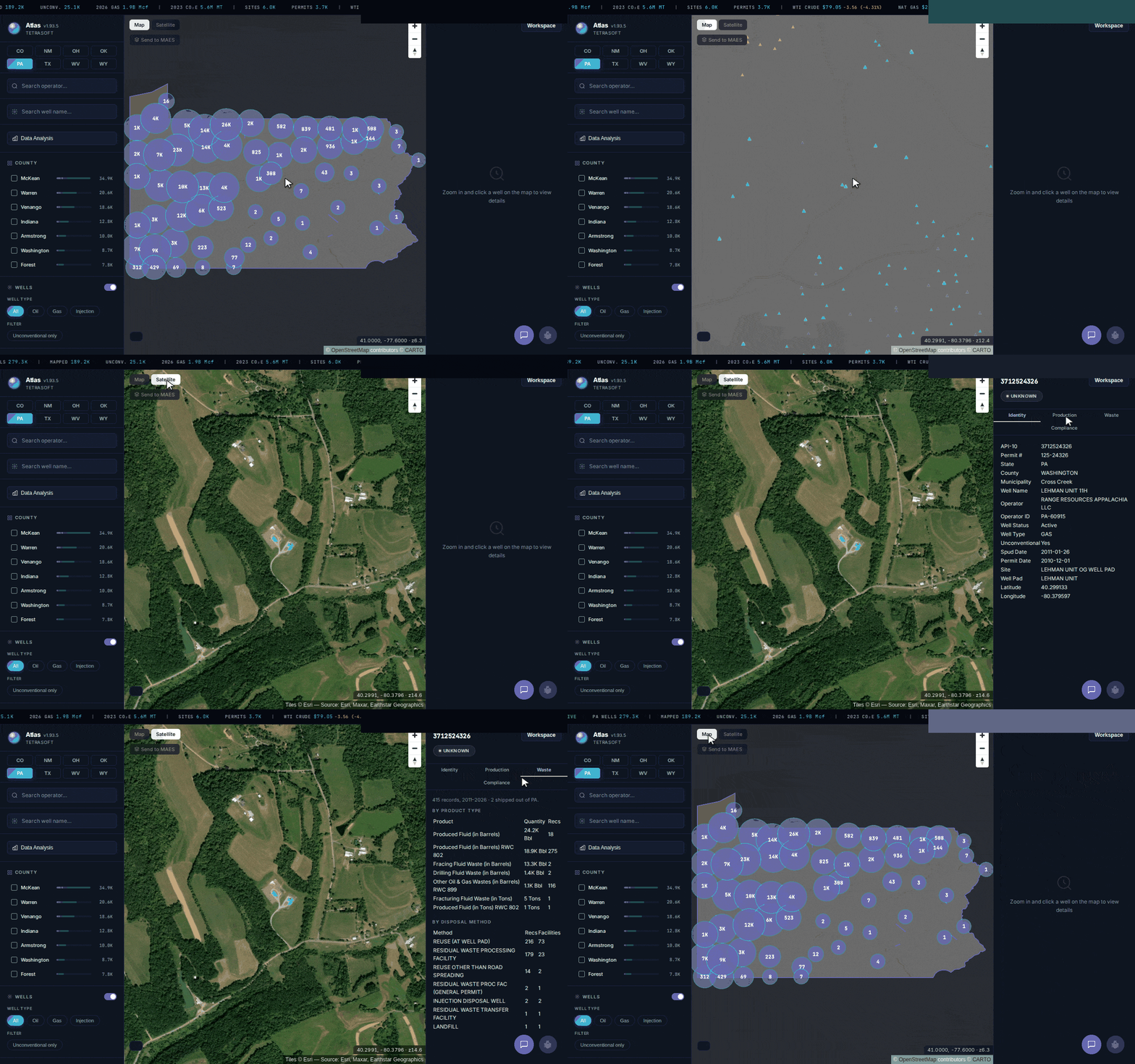
TetraSoft Atlas in Pennsylvania: the statewide map, satellite view, then one well’s identity, production, waste and DEP compliance record.
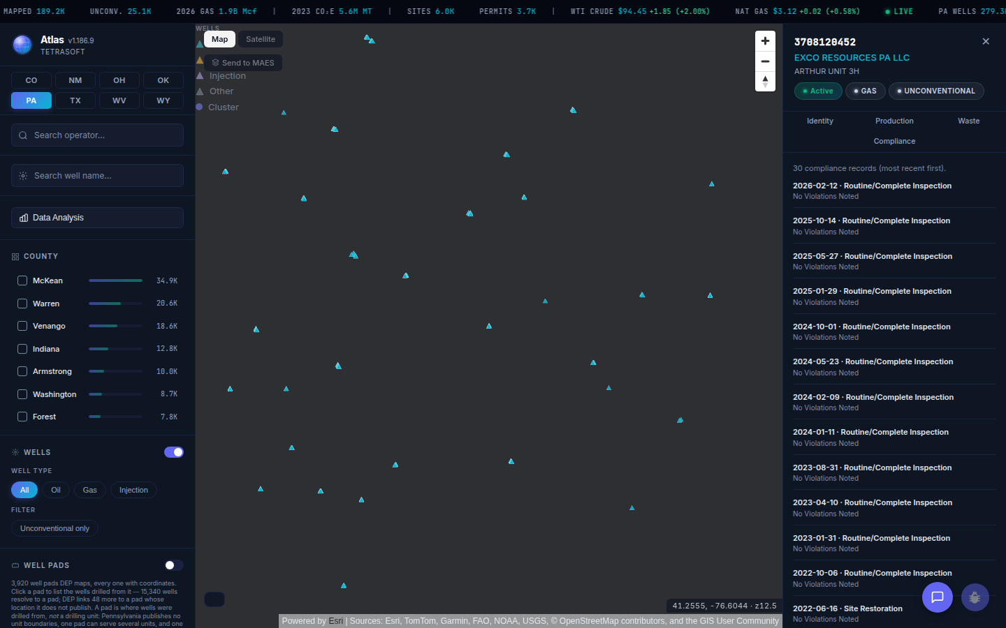
A Pennsylvania well’s Compliance tab in TetraSoft Atlas lists its inspections, violations and enforcement as filed with the Department of Environmental Protection, most recent first (local Atlas snapshot, September 2026). [12]
In Atlas, a target’s operator is searched state by state, the way each regulator files it [12]. Within each state, the operator’s wells come up on one map, with production and enforcement records wherever Atlas carries them for that state [12].
Plugging Liability and Injection Wells Outlast the Closing
Plugging liability follows the operator of record in Texas, which makes it a record a buyer cannot leave to the seller. Other states and federal leases set their own rules; the purchase agreement allocates cost between the parties, but BLM keeps sellers liable for pre-approval plugging.
In Texas, the operator named on Form P-4 certifies responsibility for plugging the wells in accordance with Statewide Rule 14 [2]. The Commission will not approve the transfer unless the acquiring operator has a bond, letter of credit or cash deposit on file [2]. After approval, the new operator has 6 months to plug, reactivate or extend each inactive well it takes on [16].
Wells their operators never plug can become a public cost.
The eight states covered here had received $756 million in federal orphaned well grants by September 30, 2025 [3]. That is 49% of the $1.54 billion awarded to the 26 states funded through the State Program [3]. Texas alone received $254 million, about twice Oklahoma’s $128 million, the next-largest award [3]. The chart shows each state’s total by grant type.
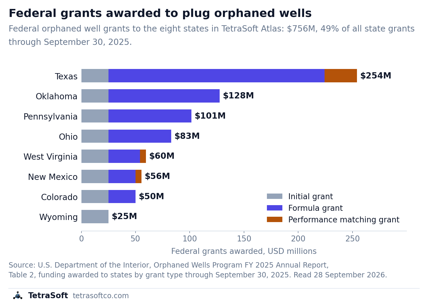
Federal orphaned well grants to the eight Atlas states through September 30, 2025, by grant type (U.S. Department of the Interior, Orphaned Wells Program FY 2025 Annual Report, Table 2). [3]
For a selection of wells in Texas, Pennsylvania or Ohio, TetraSoft Atlas counts the idle unplugged wells [8]. It shows a sourced range for what plugging them could cost [8]. That is an exposure estimate, not a bonding assessment, so the bond check still goes to the state regulator [8].
Its orphan well layer has data in seven states: Texas, New Mexico, Oklahoma, Colorado, Wyoming, Pennsylvania and Ohio, but not West Virginia [8]. Each layer uses that state’s own list, except Colorado’s, which comes from a 2022 USGS dataset whose Colorado rows date from July 2019 [8]. For newer Colorado entries, check the list the state publishes through the ECMC’s Orphaned Well Program. The Abandoned Gas Wells: What They Are and Where to Find Them guide explains how orphaned, abandoned and plugged differ.
Check Who Regulates the Injection Wells
Injection records sit with the state that holds primacy for underground injection control (UIC), or with EPA where no state does, as in Pennsylvania [17]. EPA directly implements the UIC program in Pennsylvania, while in West Virginia the state Department of Environmental Protection holds primacy [17]. Class II wells inject fluids associated with oil and gas production, mostly the brine that comes up with them.
A target that disposes of its own produced water owns those obligations, and one that trucks it out depends on someone else’s permits. The Class II Injection Wells and the Other UIC Classes, Explained guide covers the well classes.
In Atlas, injection records appear on the well panel in Texas, New Mexico, Oklahoma and Wyoming [8]. Oklahoma, Colorado, Wyoming, Pennsylvania and West Virginia show them as underground injection control (UIC) layers, and Oklahoma’s Injection tab adds monthly volumes [8]. The Oil and Gas Data Analytics Platforms: How to Choose One guide compares the platforms that carry these records.
This post is for informational purposes only and does not constitute legal or compliance advice. Consult qualified legal counsel or a compliance professional for guidance specific to your operations and jurisdiction.
Frequently Asked Questions
Which federal oil and gas records belong on a due diligence checklist?
On federal and Indian leases, BLM inspection and Incident of Noncompliance records add to the state record, and two EPA sources add more [5]. ECHO holds federal compliance and enforcement information by facility, with a screener across a company’s facilities [7]. The Greenhouse Gas Reporting Program holds emissions for oil and gas facilities at or above 25,000 metric tons of CO2e a year [9].
What is an orphaned well, and how many are there?
Under the Infrastructure Investment and Jobs Act, an orphaned well is generally one not used for an authorized purpose [3]. Its operator cannot be located, or cannot plug it and restore the site [3].
The Interstate Oil and Gas Compact Commission (IOGCC) is a body whose members are the governors of oil and gas producing states [18]. Its 2024 survey counted 141,959 documented orphaned wells in the 29 states that answered, as of December 31, 2023 [19]. Those states estimated 250,000 to 740,000 undocumented ones, and six gave no estimate [19].
How much does TetraSoft Atlas cost?
Atlas plans scale with the number of seats, up to 15 on the listed plans, and larger teams contact TetraSoft [12]. Every listed plan starts with a 7-day free trial that needs no credit card and no sales call [12]. Current prices are on the Atlas pricing page.
TetraSoft Atlas puts much of the target’s regulatory record on one map, in eight states including Texas, Oklahoma and Pennsylvania, before the data room closes [12]. Start your free 7-day trial.
References
- U.S. Energy Information Administration, crude oil field production and natural gas marketed production by state, annual 2025, accessed 28 September 2026. https://www.eia.gov/dnav/pet/pet_crd_crpdn_adc_mbbl_a.htm; https://www.eia.gov/dnav/ng/ng_prod_sum_a_EPG0_VGM_mmcf_a.htm
- Form P-4 Instructions, Railroad Commission of Texas. https://www.rrc.texas.gov/media/kx0hcdrw/p-4-ins.pdf
- U.S. Department of the Interior, Orphaned Wells Program FY 2025 Annual Report. https://www.doi.gov/sites/default/files/documents/2025-11/fy-2025-orphaned-wells-congressional-report.pdf
- Oklahoma Tax Commission, Gross Production. https://oklahoma.gov/tax/businesses/gross-production.html
- U.S. Bureau of Land Management, Oil and Gas Inspection and Enforcement. https://www.blm.gov/programs/energy-and-minerals/oil-and-gas/inspection-and-enforcement
- Colorado Energy and Carbon Management Commission, Rule 523, Complete Rules effective October 30, 2025. https://ecmc.colorado.gov/sites/g/files/lrnvjt1211/files/documents/Complete%20Rules_%28100%20Series-1300%20Series%29_Effective%20October%2030%202025_.pdf
- U.S. EPA, Learn More About ECHO. https://echo.epa.gov/resources/general-info/learn-more-about-echo
- TetraSoft Atlas production platform, read October 27, 2026. https://www.tetrasoftco.com/atlas-landing.html
- U.S. EPA, Subpart W: Petroleum and Natural Gas Systems. https://www.epa.gov/ghgreporting/subpart-w-petroleum-and-natural-gas-systems
- 40 CFR 98.238, Definitions for Subpart W. https://www.ecfr.gov/current/title-40/chapter-I/subchapter-C/part-98/subpart-W/section-98.238
- Colorado Department of Public Health and Environment, ONGAEIR. https://cdphe.colorado.gov/ongaeir
- TetraSoft Atlas, eight-state oil and gas dataset read September 2026. https://www.tetrasoftco.com/atlas-landing.html
- TetraSoft Atlas landing page FAQ. https://www.tetrasoftco.com/atlas-landing.html
- Production Data Query System FAQs, Railroad Commission of Texas. https://www.rrc.texas.gov/about-us/faqs/oil-gas-faq/production-data-query-system-faqs/
- Ohio Revised Code, Section 1509.11. https://codes.ohio.gov/ohio-revised-code/section-1509.11
- Transferring Wells to New Operators, Railroad Commission of Texas. https://www.rrc.texas.gov/oil-and-gas/compliance-enforcement/hb-2259hb-3134-inactive-well-requirements/transferring-wells-to-new-operators/
- U.S. EPA, Underground Injection Control in EPA Region 3. https://www.epa.gov/uic/underground-injection-control-epa-region-3-de-dc-md-pa-va-and-wv
- Interstate Oil and Gas Compact Commission, home page. https://oklahoma.gov/iogcc.html
- Interstate Oil and Gas Compact Commission, Idle and Orphan Oil and Gas Wells, 2024. Revised September 27, 2024. https://oklahoma.gov/content/dam/ok/en/iogcc/documents/publications/Orphan%20Wells%20Revised.pdf
Interactive tool
Plan the record pulls for a target
Tick every state where the target has wells. Each state is ten record pulls; the planner counts how many TetraSoft Atlas answers on its map and names the free source for the rest.
Record pulls answered on one TetraSoft Atlas map
14 of 20
Across 2 state systems. 6 pulls go to the state or EPA by hand, listed below.
Colorado 8 of 10 in Atlas
- Operator Atlas: Site record
- Wells Atlas: Well list on the site record
- Production Atlas: Site production tab, annual and monthly
- Permits Atlas: Permit list, searchable by operator
- Spills Atlas: Enforcement tab: spill reports
- Inspections Pull from ECMC GIS Online Map, then ask the Energy and Carbon Management Commission (ECMC)
- Violations and enforcement Atlas: Enforcement tab: ECMC notices of alleged violation
- Emissions Atlas: ONGAEIR site emissions (CDPHE)
- Plugging liability Pull from ECMC GIS Online Map, then ask the Energy and Carbon Management Commission (ECMC)
- Injection Atlas: UIC injection well layer
New Mexico 6 of 10 in Atlas
- Operator Atlas: Well record
- Wells Atlas: Well record
- Production Atlas: Production tab, monthly
- Permits Atlas: Permit dates on the Lifecycle tab
- Spills Atlas: Spills tab and spills map layer
- Inspections Pull from OCD Oil and Gas Map, then ask the Oil Conservation Division (OCD)
- Violations and enforcement Pull from OCD Oil and Gas Map, then ask the Oil Conservation Division (OCD)
- Emissions Pull from EPA GHGRP data (FLIGHT)
- Plugging liability Pull from OCD Oil and Gas Map, then ask the Oil Conservation Division (OCD)
- Injection Atlas: Injection tab
Ohio 7 of 10 in Atlas
- Operator Atlas: Well record
- Wells Atlas: Well record
- Production Atlas: Production tab, annual
- Permits Atlas: Permit date on the well record
- Spills Pull from ODNR Oil & Gas Well Locator, then ask the Ohio Department of Natural Resources (ODNR)
- Inspections Atlas: Inspections tab
- Violations and enforcement Atlas: Violations flagged on the Inspections tab
- Emissions Atlas: EPA GHGRP facility emissions
- Plugging liability Pull from ODNR Oil & Gas Well Locator, then ask the Ohio Department of Natural Resources (ODNR)
- Injection Pull from ODNR Oil & Gas Well Locator, then ask the Ohio Department of Natural Resources (ODNR)
Oklahoma 5 of 10 in Atlas
- Operator Atlas: Well record
- Wells Atlas: Well record
- Production Pull from Oklahoma Tax Commission, production by lease (PUN)
- Permits Atlas: Drilling permit history on the well record; active permits on the map
- Spills Pull from OCC Well Data Finder, then ask the Oklahoma Corporation Commission (OCC)
- Inspections Pull from OCC Well Data Finder, then ask the Oklahoma Corporation Commission (OCC)
- Violations and enforcement Pull from OCC Well Data Finder, then ask the Oklahoma Corporation Commission (OCC)
- Emissions Atlas: EPA GHGRP facility emissions
- Plugging liability Pull from OCC Well Data Finder, then ask the Oklahoma Corporation Commission (OCC)
- Injection Atlas: UIC and Arbuckle injection well layers, monthly injection volumes on the well panel
Pennsylvania 8 of 10 in Atlas
- Operator Atlas: Well record
- Wells Atlas: Well record
- Production Atlas: Production tab
- Permits Atlas: Permit number and date on the well record
- Spills Pull from PA Oil and Gas Mapping, then ask the Department of Environmental Protection (DEP)
- Inspections Atlas: Compliance tab: inspections, violations, enforcement and penalties
- Violations and enforcement Atlas: Compliance tab: violations, enforcement and penalties
- Emissions Atlas: EPA GHGRP facility emissions
- Plugging liability Pull from PA Oil and Gas Mapping, then ask the Department of Environmental Protection (DEP)
- Injection Atlas: UIC injection well layer
Texas 8 of 10 in Atlas
- Operator Atlas: Well record
- Wells Atlas: Well record
- Production Atlas: Production tab, allocated per well from the lease total
- Permits Atlas: Drilling permit on the well record
- Spills Pull from RRC district office for the well
- Inspections Atlas: Inspections tab, with Notices of Violation
- Violations and enforcement Atlas: Notices of Violation on the Inspections tab
- Emissions Atlas: EPA GHGRP facility emissions
- Plugging liability Pull from RRC Form P-4 transfer rules and cost calculation
- Injection Atlas: Injection well filter and injection tab
West Virginia 5 of 10 in Atlas
- Operator Atlas: Well record
- Wells Atlas: Well record
- Production Atlas: Production tab
- Permits Pull from Department of Environmental Protection (WVDEP): WVDEP Oil and Gas Well Information map
- Spills Pull from WVDEP Oil and Gas Well Information map, then ask the Department of Environmental Protection (WVDEP)
- Inspections Pull from WVDEP Oil and Gas Well Information map, then ask the Department of Environmental Protection (WVDEP)
- Violations and enforcement Pull from WVDEP Oil and Gas Well Information map, then ask the Department of Environmental Protection (WVDEP)
- Emissions Atlas: EPA GHGRP facility emissions
- Plugging liability Pull from WVDEP Oil and Gas Well Information map, then ask the Department of Environmental Protection (WVDEP)
- Injection Atlas: UIC injection well layer
Wyoming 7 of 10 in Atlas
- Operator Atlas: Well record
- Wells Atlas: Well record
- Production Atlas: Production tab, monthly and annual
- Permits Atlas: Drilling permit on the well record
- Spills Atlas: WDEQ spills map layer
- Inspections Pull from WOGCC WellFinder app, then ask the Wyoming Oil and Gas Conservation Commission (WOGCC)
- Violations and enforcement Pull from WOGCC WellFinder app, then ask the Wyoming Oil and Gas Conservation Commission (WOGCC)
- Emissions Atlas: EPA GHGRP facility emissions
- Plugging liability Pull from WOGCC WellFinder app, then ask the Wyoming Oil and Gas Conservation Commission (WOGCC)
- Injection Atlas: UIC injection well layer and injection tab
Outside the eight states, all ten records come from that state's oil and gas regulator, with emissions from EPA's GHGRP. Atlas is expanding to every US state.
See what TetraSoft Atlas holds
Atlas coverage read from the production platform, October 2026. Atlas does not estimate plugging cost or show bonds, so plugging liability is always a state pull. Free sources are each agency's own map or data. Nothing you tick or type leaves your browser.
Comments
0Share your thoughts. All comments are moderated before appearing.
No comments yet. Be the first to share your thoughts!