On April 17, 2017, a house in Firestone, Colorado, exploded, killing a resident and a plumber working inside [1]. Federal investigators traced the gas to a well about 170 feet away, through an improperly abandoned flowline most likely cut during construction [1]. The Board also faulted approving homes beside production fields without complete records of where those lines ran [1].
Questions “frequently arise when owners of residential property in suburban and rural areas discover” oil and gas work nearby, Texas’s regulator says [2]. This guide shows how to see the recorded wells around your street, what each one has been doing, and who to call about one.
Quick Answer: Open TetraSoft Atlas, our subscription platform, and zoom to your street: the recorded wells around it appear over satellite imagery [3]. Outside Pennsylvania and West Virginia, each symbol also shows the well’s status [3]. Click one to see who operates it and what it has produced [3]. In Texas, Ohio and Pennsylvania, Atlas also shows the state’s inspections of each well and the orphan wells nearby [3]. Each state’s free agency map shows well locations too, one state at a time [4].
How to See the Wells Around Your Home in TetraSoft Atlas
Zoom TetraSoft Atlas to your neighborhood, switch to satellite, and each well appears over the rooftops around it [3]. Atlas maps the recorded wells of eight states, and coverage is expanding to every US state [3]. Outside Pennsylvania and West Virginia, its symbol shows its status at a glance, so a producing well reads apart from a plugged one [3].
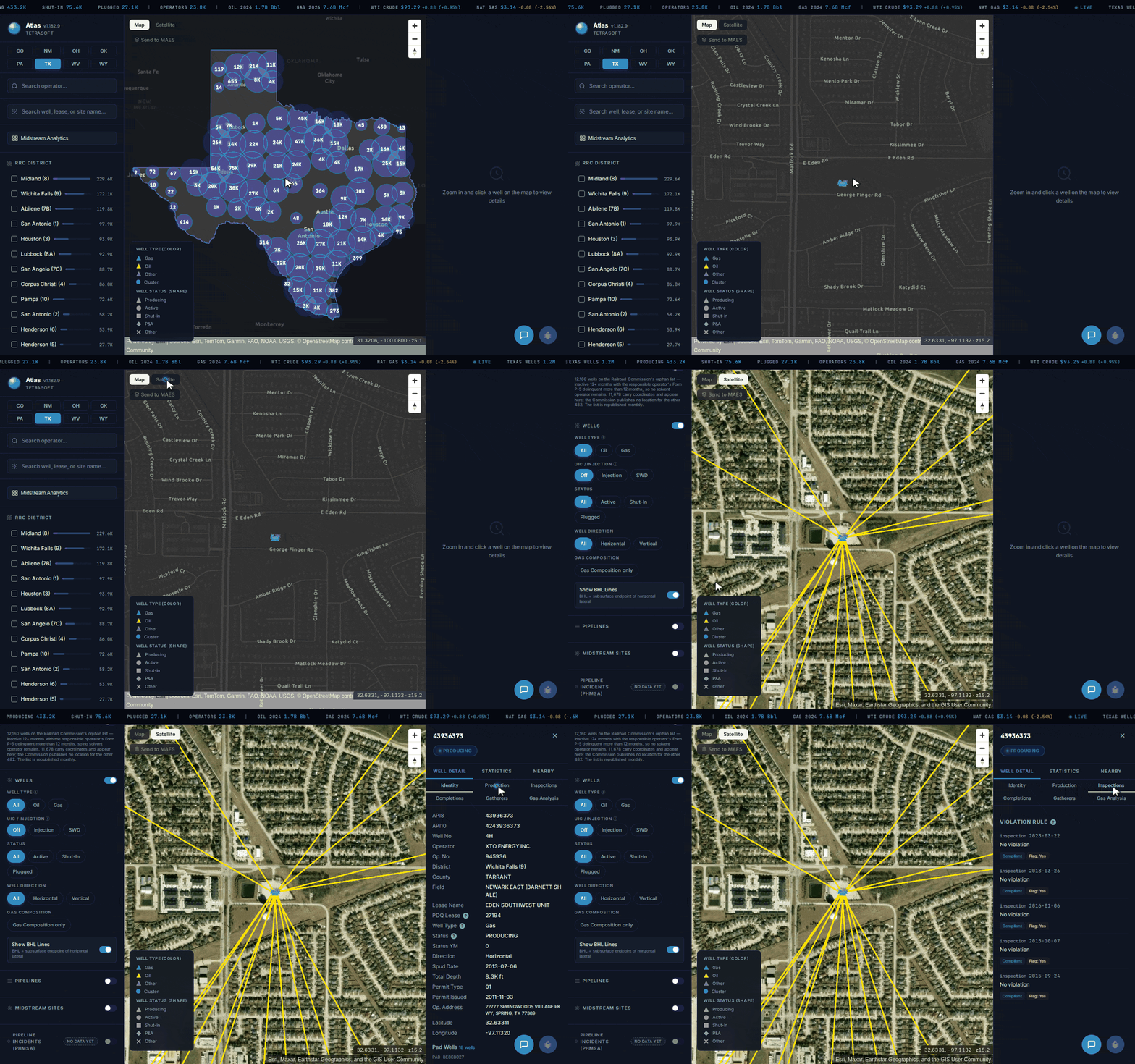
A drilling pad inside an Arlington, Texas subdivision, its horizontal wells running under the homes around it, then one well’s record. [3]
Click a well and its record opens beside the map, showing who operates it and how much it has produced over the years [3]. That history answers what a homeowner really wants to know: is the well still producing, or has it stopped?
An idle, unplugged well deserves the closest look. Texas counts a well as orphaned once it sits inactive 12 months and its operator’s Form P-5 is delinquent over 12 months [5]. In Texas, Ohio and Pennsylvania, the record also lists each state inspection of the well [3].
Take a drilling pad in Arlington, Texas, where XTO Energy operates the EDEN SOUTHWEST UNIT 4H well [3]. The pad lists 18 wells, 12 of them producing gas from the Barnett Shale [3]. The 4H well produced 803,051 Mcf of gas in 2014 and 92,202 Mcf in 2025 [3]. State inspectors visited it five times from 2015 to 2023 [3].
See Whether a Horizontal Well Runs Under Your Street
In Texas, Oklahoma and Wyoming, turn on the lateral lines in TetraSoft Atlas to see roughly where each well runs beneath your block [3]. A horizontal well does not stay under its pad: it turns sideways deep underground and can run beneath the homes around it [3]. On the Arlington pad, Atlas draws lateral lines for 16 wells [3]. The longest ends about 5,600 feet from the pad, more than a mile away [3].
Click the well at the end of a line to see who operates it [3].
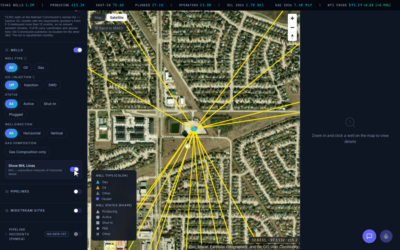
A horizontal well’s surface pad is not where it produces: each line runs from the pad to where that wellbore ends underground. [3]
That matters because of how Texas splits land ownership. In Texas, the minerals under a lot are often owned separately from the house on top of it [2]. Seeing the wells beneath you, and who runs them, is where the next questions start. Do you own those minerals, and what is being produced from them?
Check for Orphan Wells Around Your Home
Switch on the orphan well layer in TetraSoft Atlas to see the orphan wells mapped around your home in Ohio, Pennsylvania and Texas [3].
An orphan well is an abandoned well that has not been properly plugged and has no company left responsible for it [6]. Federal reviewers say such wells “provide uncontrolled pathways for methane and other substances to migrate upwards towards the surface.” [7] Pennsylvania’s agency says old wells have been found during landscaping and construction, and within the foundations and basements of homes [8].
Old abandoned wells can also carry gas that starts somewhere else. In January 2001, gas leaking from a storage well 8 miles away erupted in Hutchinson, Kansas, through abandoned brine wells [9]. Some of those brine wells had been drilled as long ago as the 1880s [9]. The next day, gas exploded under a mobile home in town, and both residents died of their injuries [9].
The layer sits in the left panel [3]. Zoomed to your area, they appear alongside the other mapped wells, so a mapped orphan two streets over is not a surprise at closing [3]. For how New Mexico sorts inactive wells into temporarily abandoned, plugged and orphaned, see Abandoned Gas Wells: What They Are and Where to Find Them.
Check the Official State Well Map for Free
Colorado, New Mexico, Ohio, Oklahoma, Pennsylvania, Texas, West Virginia and Wyoming each publish a free well map or app, and five document an address search [4]. Each map is the regulator’s own record. In Texas, for example, the Commission’s viewer shows where a well is, while production and inspections sit in separate files [10]. Each map also covers only its own state, so a property near a state line means checking two.
Pick your state below to see its map, what it can search, and where to report an abandoned well [4].
| State | Official well map | Address search | Report an abandoned well |
|---|---|---|---|
| Colorado | ECMC GIS Online Map | Yes | ECMC complaint form, (303) 894-2100 |
| New Mexico | OCD Oil and Gas Map | Well or township; Near Me tool | OCD, (505) 629-6116; after hours (505) 320-0243 north, (505) 670-8745 south |
| Ohio | ODNR Oil & Gas Well Locator | Yes | ODNR Orphan Well Program, (330) 308-0007 |
| Oklahoma | OCC Well Data Finder | Yes | OCC complaint form, (405) 521-2331 |
| Pennsylvania | PA Oil and Gas Mapping | Yes | DEP Report an Abandoned Well form |
| Texas | RRC Public GIS Viewer | Yes | RRC Oil & Gas district office; 844-773-0305 for leaks |
| West Virginia | WVDEP well map | Not documented | WVDEP Orphaned Well Reporting Form, (304) 926-0499 |
| Wyoming | WOGCC WellFinder app | Not documented | WOGCC, (307) 234-7147 |
Whichever map you use, note each nearby well’s API number as well as its position. That number ties together its permit, completion and plugging records, as the API Well Number Lookup: What It Is and How to Read One guide explains. In Texas, production is filed by lease, so note the lease name too [10].
Why a Well’s Map Point Is Only Approximate
A mapped well is a starting point for older wells, not a surveyed location. Ohio’s agency says its well data “are derived from multiple sources and the locational quality may be varied.” [11] West Virginia’s agency says it “does not guarantee accuracy, precision, or completeness.” [4]
On a small lot, confirm a well’s position against survey plats and on the ground. The Oil Well Locations: Where to Find Them and What They Mean guide shows how far a horizontal well’s surface point can sit from where it produces.
What to Do If You Find an Abandoned Well on Your Property
If you smell gas or see a leak, move away and call 911 first. Otherwise, leave the well alone and report it to the state oil and gas agency listed above. Finding one does not by itself make it yours to fix, at least in Pennsylvania [8]. The agency warns that trying to produce it, profit from it or hide it can make you financially responsible [8].
In limited cases, a well tied to the property’s deed can leave the landowner responsible [8]. Pennsylvania law also requires reporting a found well within 60 days [8].
The U.S. Geological Survey writes that “Orphan wells benefit no one, they waste natural resources, contaminate water, and pose a threat to the environment.” [6]
The Interstate Oil and Gas Compact Commission counts over 141,000 documented orphaned wells on state and private land [12]. The same commission estimates 250,000 to 740,000 more undocumented orphaned wells nationwide, wells missing from regulators’ records [12].
When you report, give the agency what makes a well findable. Send a photo, the GPS coordinates from your phone, and any API number or lease name you found on the map. The table above lists each state’s reporting form or phone line [4].
Frequently Asked Questions
How close can an oil or gas well be to a house?
Setback rules vary by state. Colorado bars a new well pad within 500 feet of a home unless every owner and tenant there gives informed consent [13]. From 500 to 2,000 feet, it needs consent or another listed exception [13]. Texas preempts city drilling rules but lets cities set reasonable setbacks [14].
Is it safe to live near an oil well?
Safety depends on how close a well is and whether it is maintained or left unplugged. Colorado’s health department modeled possible short-term health effects, under worst-case conditions, from 300 to 2,000 feet of well pads [15]. Federal reviewers call orphaned wells uncontrolled pathways for methane [7].
Who is responsible for an abandoned oil well on my property?
The well’s operator, while one is on record and able to act. An orphan well has none left, which is why states run programs to plug them. Pennsylvania says buying land with an old well generally does not make you responsible, except in limited cases tied to the deed [8].
Should I check for oil wells before buying a house?
Yes. Colorado’s standard home purchase contract encourages buyers to seek information about oil and gas activity on or adjacent to the property [16]. In Colorado, also check the state’s public flowline map, since Firestone’s gas came through a line, not a well [17].
How much does TetraSoft Atlas cost?
Atlas plans scale with the number of seats, and self-serve plans start with a 7-day free trial [3]. The trial needs no credit card, and no sales call is required [3]. For current plans and prices, see the Atlas pricing page [3].
You searched for wells near your home because you want to know whether one of them should worry you. TetraSoft Atlas answers that on one screen, showing who operates each well around your street and what it has produced [3]. In Texas, Ohio and Pennsylvania it adds each well’s inspections and the orphan wells nearby, and the trial needs no credit card [3]. Start your free 7-day trial.
This post is for informational purposes only and does not constitute legal or compliance advice. Consult qualified legal counsel or a compliance professional for guidance specific to your operations and jurisdiction.
References
- National Transportation Safety Board, Pipeline Accident Brief PAB-19/02. Residential Explosion in Firestone, Colorado, April 17, 2017. https://www.ntsb.gov/investigations/AccidentReports/Reports/PAB1902.pdf
- U.S. Department of the Interior, Orphaned Wells Program, FY2024 report to Congress. https://www.doi.gov/sites/default/files/documents/2024-11/fy-2024-owpo-annual-congressional-reportfinal-publishing.pdf
- Railroad Commission of Texas, Oil and Gas Exploration and Surface Ownership FAQ. https://www.rrc.texas.gov/about-us/faqs/oil-gas-faq/oil-gas-exploration-and-surface-ownership/
- TetraSoft Atlas, eight-state oil and gas dataset read September 2026. Well, production, inspection, lateral and orphan well records from the Railroad Commission of Texas and the other seven state agencies, as served by Atlas. https://tetrasoftco.com/atlas-landing.html
- State oil and gas agency well maps and contact pages, read September 2026. ECMC GIS Online Map; NM OCD Oil and Gas Map and contact page; OCC Well Data Finder and complaint page; PA DEP Oil and Gas Mapping and abandoned well form; RRC complaints page; WVDEP Office of Oil and Gas map and report-a-well page; WOGCC WellFinder and orphan well program.
- Railroad Commission of Texas, Orphan Wells with Delinquent P-5 Greater Than 12 Months. https://www.rrc.texas.gov/oil-and-gas/research-and-statistics/well-information/orphan-wells-12-months/
- U.S. Geological Survey, Orphan Wells. Central Energy Resources Science Center. https://www.usgs.gov/centers/central-energy-resources-science-center/science/orphan-wells
- Pennsylvania Department of Environmental Protection, Legacy Wells: Landowner Information. https://www.pa.gov/agencies/dep/programs-and-services/oil-and-gas/legacy-wells/landowner-information
- Kansas Geological Survey, Allison, The Hutchinson Gas Explosions: Unraveling a Geologic Mystery, 2001. https://www.kgs.ku.edu/Hydro/Hutch/Refs/Hutch_KBA_final.pdf
- Railroad Commission of Texas, Data Sets Available for Download. https://www.rrc.texas.gov/resource-center/research/data-sets-available-for-download/
- Ohio Department of Natural Resources, Oil & Gas Well Locator. https://ohiodnr.gov/business-and-industry/energy-resources/well-information/well-locator; app description at https://www.arcgis.com/home/item.html?id=5fd9c17bc933417d9bd8d7c1dff404aa
- U.S. Department of the Interior, Orphaned Wells Program, FY2025 report to Congress. Orphaned Wells Program Office annual report, November 2025. https://www.doi.gov/sites/default/files/documents/2025-11/fy-2025-orphaned-wells-congressional-report.pdf
- Colorado Energy and Carbon Management Commission, Rule 604. Complete Rules, effective October 30, 2025. https://ecmc.colorado.gov/sites/g/files/lrnvjt1211/files/documents/Complete%20Rules_%28100%20Series-1300%20Series%29_Effective%20October%2030%202025_.pdf
- Texas Legislature, House Bill 40 (2015), Natural Resources Code Section 81.0523. https://capitol.texas.gov/tlodocs/84R/billtext/html/HB00040F.htm
- Colorado Department of Public Health and Environment, oil and gas health risk study, 2019. https://cdphe.colorado.gov/press-release/state-health-department-publishes-oil-and-gas-health-risk-study
- Colorado Division of Real Estate, Contract to Buy and Sell Real Estate (Residential), 2026. Section 8.8.4, for use on or after January 1, 2026. https://dre.colorado.gov/sites/dre/files/documents/Contract%20to%20Buy%20and%20Sell%20Real%20Estate%20%28Residential%29%20V2%20%28fillable%29_for%20use%20on%20or%20after%20January%201,%202026.pdf
- Colorado Energy and Carbon Management Commission, Flowlines GIS Data. https://ecmc.colorado.gov/data-maps-reports/maps-gis/flowlines-gis-data
Interactive tool
Find wells near a property, state by state
Pick your state to see the official map that finds oil and gas wells near an address, what it can search, and how to report an abandoned well.
Railroad Commission of Texas (RRC)
Takes an address and draws a radius around it.
- Search by address
- Yes
- Radius or buffer tool
- Yes. Radius tool
- Shows orphan wells
- Partly. Plugged wells shown; orphans are in a separate Orphan Well Query
Found an abandoned well?
Contact the RRC Oil & Gas district office; leaks and spills go to the 24-hour line
Open the agency page 844-773-0305
Read from each state agency's own pages, September 2026. "Not documented" means the agency's pages do not say the tool does it, not that it cannot. Mapped well locations are approximate; every agency here says so. Nothing leaves your browser.
Comments
0Share your thoughts. All comments are moderated before appearing.
No comments yet. Be the first to share your thoughts!