A drilling permit, or the application for one, is among the earliest public signs that someone plans a well near you. If you sell to operators, own minerals or research and negotiate mineral leases as a landman, that early notice is worth money. Each permit names the operator, the company responsible for the well, and the lease, the tract it holds rights to [1].
A new Texas oil or gas well cannot be drilled until the Railroad Commission of Texas grants its drilling permit, applied for on Form W-1 [2]. Form W-1 is the application an operator files for a permit to drill, and the permit is the Commission’s approval of it [3]. The Railroad Commission of Texas (RRC) is the state agency with primary jurisdiction over oil and gas, and it no longer regulates railroads [4].
The Commission approved 7,424 original drilling permits in 2025, 6,528 of them to drill a new well [5]. It approved 695 in August 2026 alone, 594 of them new drills [5].
The problem is that a raw permit search misleads. It mixes original permits, the first approvals, with amendments, the later revisions to a permit already approved [1]. A permit search’s results list also does not show whether the well was spudded, meaning that drilling began. The Commission adds the spud date to the permit record once the operator reports it.
This Texas-only guide answers four questions, in this order. They are how to search by county, which counties lead, how the Commission publishes and codes permits, and whether a permitted well was drilled. It is written for landmen, mineral owners and service sellers who need county-level leads.
Other states run their own permit systems, so the steps here apply to Texas alone. The guide covers oil and gas permits only. Private water-well drilling is regulated separately, by the Texas Department of Licensing and Regulation [6].
To check whether a permitted well was spudded and produces, open it in TetraSoft Atlas, our subscription platform for well records [7]. Atlas shows a Texas well’s latest permit and that permit’s spud date, and on another tab the well’s share of lease production [7]. In Atlas, the well panel is the record that opens when you click a well on the map [7].
Quick Answer: Search Texas drilling permits in the Railroad Commission’s Drilling Permit (W-1) Query [1]. Pick the county, enter the approved date range, and set Amended to No [1]. For Midland County from September 2025 to August 2026, that returns 652 permits; leaving Amended blank returns 914, because amendments are listed as well [1]. TetraSoft Atlas shows a Texas well’s latest permit type and issue date on its well panel, for wells with a permit on file [7].
How Do You Search Texas Drilling Permits by County?
Use the Commission’s Drilling Permit (W-1) Query, choose the county, and bound it by approved date [1]. All the criteria you set must be true for a permit to appear, so adding a field narrows the list or leaves it unchanged [1]. The query takes dates as MM/DD/YYYY, in an Approved Date From and an Approved Date To box [1]. That means month, day and four-digit year, such as 09/01/2025 [1].
Three settings give one row per permit: the county, the approved dates and Amended [1]. Start by picking the county from the County list; DeWitt appears there as “DE WITT” [1]. Then enter the approved dates you want. Last, set Amended to No, so each permit appears once rather than once per revision [1].
The Amended setting decides whether a county’s count also lists each amendment approved in the date range as its own row [1]. That last setting changes the answer a lot. Midland County’s search for September 2025 to August 2026 returned 652 permits with Amended set to No, and 914 with it left blank [1]. Adding Filing Purpose “New Drill” returned 650, so 650 of the 652 Midland permits (99.7%) were permits to drill a new well [1].
Result columns include the API number, district, lease, well number, permitted operator, county, submitted and approved dates, filing purpose, wellbore profile, total depth and status [1]. The API number is the unique number the Commission assigns to identify a wellbore.
The district is the Commission district where the drilling will take place. The filing purpose is the reason for the application, such as New Drill, and the wellbore profile is the hole’s shape, such as Horizontal [1]. Total depth is how deep the well is planned to go.
The operator, lease and total depth are what turn a count into a list of prospects.
Which Texas Counties Get the Most Drilling Permits?
Midland County led Texas from September 2025 to August 2026, with 652 original drilling permits in the Commission’s W-1 Query [1]. Reeves (502), Upton (457), Loving (433) and Martin (417) followed in the same query, each a Permian Basin county [1].
In the Commission’s permit file, the ten busiest counties took 3,705 of the 7,855 original permits placed in a county, or 47.2% [8]. The ten are Midland, Reeves, Upton, Loving, Martin, Webb, Reagan, Glasscock, Andrews and Ector [8]. The Permian counties among them, in the West Texas oil region of that name, are mapped well by well and operator by operator in Permian Basin Oil Fields: Every Well, County and Operator.
Pick any county below to see its count, its change from the year before, and the W-1 Query settings for its list [8].
The tool counts every original permit that the Commission’s permit file of October 11, 2026 places in a Texas county, amendments excluded [8]. Against the live query of September 29, 2026, it matched exactly for 16 of the 25 busiest counties, Midland and Martin among them [1]. For the other nine it came within 7, as with Reeves (501 against 502) and Upton (453 against 457) [1].
Statewide the file places 7,855 permits in counties for the twelve months [8]. That is 99.4% of the 7,900 original permits in the Commission’s monthly summaries [5].
Three permits carry offshore area codes, not one of the 254 onshore counties [8]. Two carry 606, HIGH IS-SB, and one carries 708, HIGH IS-LB, so the tool leaves them out [8]. The file dates 42 fewer permits to those months than the summaries do [8].
A live query can also return cancelled permits that the file holds as applications, with no permit record [1]. Seven Reagan County permits approved in October 2025 and January 2026 were later cancelled [1].
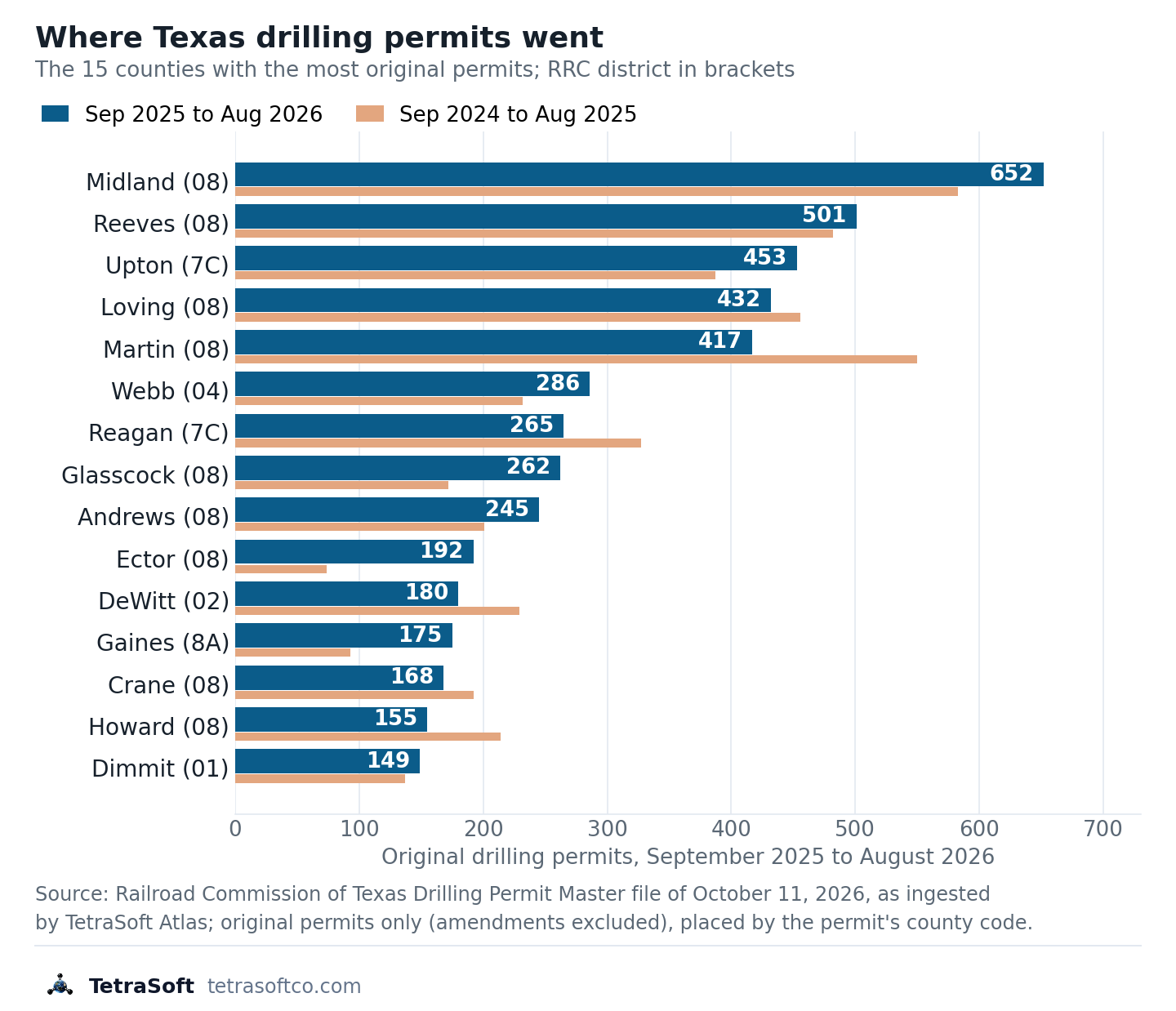
The chart shows how far the busiest counties moved in a year: Gaines rose from 93 permits to 175, while DeWitt fell from 229 to 180. [1]
How Does the Railroad Commission Publish Drilling Permits?
The Commission publishes drilling permits in several forms, including the W-1 Query for single searches, monthly statistical summaries and bulk data files [5]. The query looks up individual permits, and the summaries count the permits the Commission approved each month [5]. The data files are plain-text downloads issued monthly, nightly or, for pending applications, twice daily [9].
The monthly summary counts original permits approved, by district and by filing purpose, and excludes amended permit applications [5]. It reported 7,424 original permits for 2025, down from 8,683 in 2024 and 9,229 in 2023 [5]. District 8, the Commission’s Midland district, accounted for 3,692 of the 7,900 original permits from September 2025 to August 2026, or 46.7% [5].
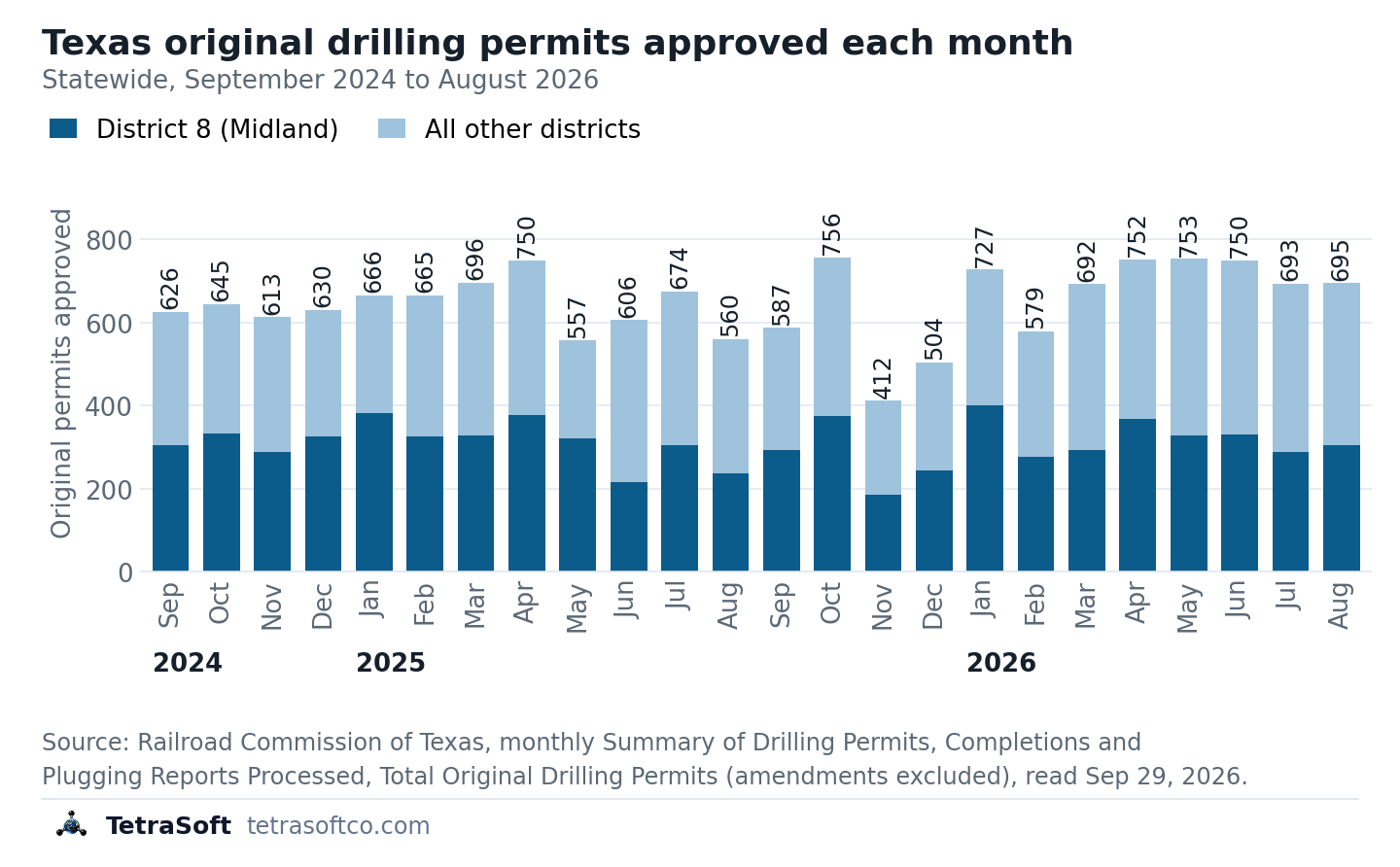
The chart shows District 8’s share of each month’s permits ranging from 35% (June 2025, 215 of 606) to 58% (May 2025, 322 of 557). [5]
The Commission also maps approved permits in a Power BI visualization, an interactive map built in Microsoft’s charting software, updated monthly for the previous month [10]. Its disclaimer says the map is “not intended to be used as an authoritative public record” [10]. The locations it shows are each well’s surface location, the spot at ground level where drilling starts [10]. The same disclaimer sends readers to the W-1 Query to view issued permits [10].
What Do the Texas Permit Codes Mean?
A Texas permit carries a two-digit code for its type [11]. The Drilling Permit Master, the Commission’s bulk permit file, has used six codes since 1995: 01, 05, 07, 09, 14 and 15 [11].
The W-1 Query uses the same numbers for its Filing Purpose choices, except that it offers no 05 [1]. The query adds two more: 16, labelled Amended as Drilled BHL, and 99 for Unknown [1]. BHL stands for bottom-hole location, the underground point where the wellbore ends.
| Code | Permit type | What it authorizes |
|---|---|---|
| 01 | Drill (New Drill) | A new wellbore |
| 05 | Other | A purpose explained in free text on the permit |
| 07 | Reenter | Re-entering a wellbore that was plugged (sealed) |
| 09 | Field Transfer | Moving an already completed well to a different regulatory field, with no work on the well |
| 14 | Recompletion | Completing an existing wellbore in a different field or reservoir |
| 15 | Reclass | Changing a well’s classification, for example from a service well to a producing well |
Codes from the Railroad Commission’s Drilling Permit Master manual, valid from January 1, 1995. [11]
An older permit can carry a retired code, such as 12 for a horizontal drill before 1995 [11]. Of those six, 01 is the code for a new well location [11].
The W-1 instructions define four other purposes by an existing well [12]. A re-entry goes back into a plugged wellbore, and a field transfer moves an already completed well [12]. A recompletion works over an existing wellbore, and a reclassification changes an existing well [12]. So 07, 09, 14 and 15 act on existing wells [12].
A 14 on a well is a permit to recomplete an existing wellbore, and the permit alone does not show the work was done.
This post is for informational purposes only and does not constitute legal or compliance advice. Consult qualified legal counsel or a compliance professional for guidance specific to your operations and jurisdiction.
For a new well, Commission staff plot the location in its GIS and issue the API number while the application sits in the Mapping Queue [13]. GIS means geographic information system, here the Commission’s digital map, and the Mapping Queue is that review step. How that number is built is explained in API Well Number Lookup: What It Is and How to Read One.
Which Rule Requires a Texas Drilling Permit?
Statewide Rule 5, the Commission rule at 16 Texas Administrative Code §3.5, bars work such as drilling, deepening or reentering until the permit is granted [2]. The same rule ends a permit no later than two years after its original approval [2].
The rule dates from January 1, 1976, and its latest amendment took effect February 18, 2025 [2]. The amendment before that took effect February 1, 2016, and the two-year limit stands in the text read October 2, 2026 [2].
Filing is outside this guide, which covers finding permits. Operators file Form W-1 through the RRC Online System or on paper, and the Commission’s drilling permits page links the filing guide [3].
How Do You See Each Texas Well’s Permit in TetraSoft Atlas?
TetraSoft Atlas shows a Texas well’s permit type and permit issue date on the well’s own panel, beside its operator, spud date and production [7].
Atlas also shows Texas drilling permits as a map layer of their own, filtered by county, operator and date [14]. Atlas is scheduled to refresh every state at least monthly, and a state’s data can lag that schedule.
What the panel adds is what a permit count leaves out: whether a permitted well was spudded and whether it produces. The panel shows the well’s latest permit, so an earlier permit on the same wellbore will not appear there [7]. So a county’s permit total counts plans, and a list built from permits alone can include permitted wells that are never drilled.
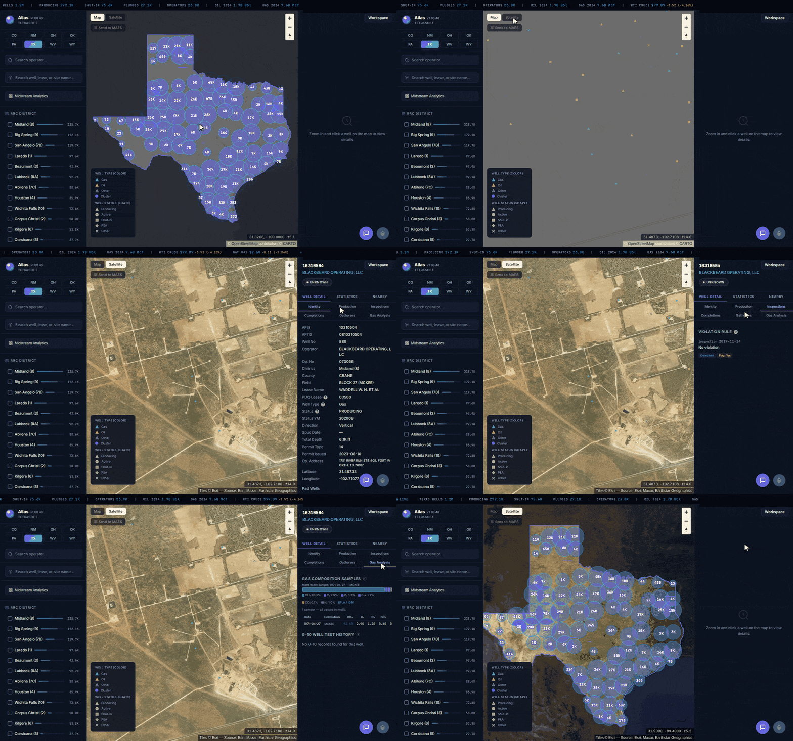
Atlas in Texas: statewide map to one well’s tabs.
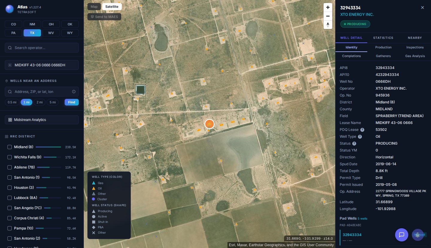
This Midland County horizontal well’s panel shows Permit Type Drill, issued May 8, 2019, and a spud date of June 14, 2019. [7] The Commission’s W-1 record for the same well lists that permit as a new drill, approved May 8, 2019, and spudded June 14, 2019. [1]
Search an operator from your W-1 results in TetraSoft Atlas to see the wells it already runs on the map [7]. Click one to read its latest permit type, spud date and monthly production on the same record [7]. Texas reports production by lease, and a gas lease holds one gas well while a single oil lease can hold numerous oil wells [15]. Atlas splits an oil lease’s monthly total evenly across its wells, so an oil well’s figure is a share of the lease [7].
Atlas covers eight states: Texas, New Mexico, Oklahoma, Colorado, Wyoming, Pennsylvania, West Virginia and Ohio [16]. In 2025 they produced 68% of US crude oil (3.40 of 4.99 billion barrels) and 83% of marketed gas (35.8 of 43.2 trillion cubic feet) [17]. We plan to expand Atlas to every US state. How Atlas compares with other platforms is covered in Oil and Gas Data Analytics Platforms: How to Choose One.
You searched Texas drilling permits to learn who plans to drill in your county, and the free W-1 Query answers that. Doing the rest for free costs work: the permit sits in one Commission query and lease production in another, checked well by well.
TetraSoft Atlas answers the next question: which of those wells were drilled, and each well’s share of its lease’s reported production [7]. It is self-serve, with no sales call, and the 7-day free trial needs no credit card.
Frequently Asked Questions
How long is a Texas drilling permit good for?
An operator has two years from the date the first filing is approved to spud the well [3]. Amending the permit afterwards does not extend that window; the Commission’s FAQ says amendments do not “prolong the life of the permit” [3]. A permit that runs out unspudded has to be applied for again, and the Commission offers a Reapply for an Expired Permit process for that [3].
Can you see Texas drilling permits that are still pending?
Yes, set Status to Pending Approval in the W-1 Query to list applications the Commission has not yet approved [1]. The Commission also generates pending-application data files twice a day [18]. It warns that a pending record “may contains [sic] errors that will be corrected prior to application approval”, so treat one as provisional [18].
Does a drilling permit mean a well will be drilled?
No. A permit authorizes drilling, and one that is not spudded within two years of approval simply expires [3]. The spud date, when drilling operations begin, is recorded separately once the operator reports it to the Commission [10]. Compare the two dates before you count a permit as a new well.
Which RRC district covers my Texas county?
The Railroad Commission publishes an Oil and Gas Division district boundary map that shows which of its districts covers each Texas county [19]. The Commission’s monthly permit news releases point readers to the same map [20]. A W-1 Query search on the county alone needs no district, because the form asks for one or more search criteria of your choosing [1].
Where can I see recently approved drilling permits for one Texas county?
Run the W-1 Query for the county with a recent approved-date range and Amended set to No, which lists each permit once [1]. To see wells on a map, use the Commission’s Public GIS Viewer, which finds a well by its API number [21]. Its permit-number searches cover discharge permits and pipelines, not drilling permits [21].
The viewer caps what it displays, at 1,000 records for a pipeline query and 1,000 wells for a radius search [21]. So zoom in on a busy county before you search [21].
How long does it take to get a drilling permit in Texas?
The Commission’s Oil and Gas Division reports approximately four business days for a standard permit and approximately two for an expedited one [22]. Its page dates those figures March 7, 2025 [22]. An expedited permit is one the applicant pays an extra fee to have reviewed sooner [23].
How much does a Texas drilling permit cost?
The Commission’s fee rule charges a drilling permit fee of $200 to $300 per application or material amendment, rising with proposed total depth [23]. With the 150 percent surcharge, the Commission’s fee table puts the total due at $500 to $750 [24]. Expediting adds $150, and an exception to the spacing or density rules adds $200 [23].
With the surcharge, the fee table puts those at $375 and $500 [24]. The Commission does not refund fees, so confirm the total before you file [3].
How much does TetraSoft Atlas cost?
Atlas plans scale with the number of seats, and every listed plan starts with a 7-day free trial. The trial needs no credit card, and no sales call is required. For current plans and prices, see the Atlas pricing page. Use the trial to see which Texas drilling permits in your county became producing wells.
References
- Railroad Commission online research query: Drilling Permit (W-1) Query, searched 29 September 2026. https://webapps2.rrc.texas.gov/EWA/drillingPermitsQueryAction.do
- 16 Texas Administrative Code §3.5, Application To Drill, Deepen, Reenter, or Plug Back, read 2 October 2026. https://www.law.cornell.edu/regulations/texas/16-Tex-Admin-Code-SS-3-5
- Railroad Commission answers to frequently asked questions on the Form W-1 drilling permit application. https://www.rrc.texas.gov/about-us/faqs/oil-gas-faq/drilling-permit-application-faqs/
- Railroad Commission About Us page, read 2 October 2026. https://www.rrc.texas.gov/about-us/
- Railroad Commission monthly Summary of Drilling Permits, Completions and Plugging Reports Processed, September 2024 to August 2026. https://www.rrc.texas.gov/oil-and-gas/research-and-statistics/drilling-information/monthly-drilling-completion-and-plugging-summaries/
- Texas Department of Licensing and Regulation Water Well Drillers and Pump Installers page, read 2 October 2026. https://www.tdlr.texas.gov/wwd/
- TetraSoft Atlas Texas permit snapshot, read 27 October 2026. https://www.tetrasoftco.com/atlas/?state=TX
- Railroad Commission Drilling Permit Master file of 11 October 2026, as ingested by TetraSoft Atlas. https://mft.rrc.texas.gov/link/e99fbe81-40cd-4a79-b992-9fc71d0f06d4
- Railroad Commission Data Sets Available for Download page, read 2 October 2026. https://www.rrc.texas.gov/resource-center/research/data-sets-available-for-download/
- Railroad Commission disclaimer for its Approved Drilling Permits and Wells Spudded Power BI maps. https://www.rrc.texas.gov/media/gmckzvcn/drillingpermitswellsspuddeddisclaimer.pdf
- Railroad Commission Drilling Permit Master data manual, OGA049. https://www.rrc.texas.gov/media/ezxjqdmn/oga049.pdf
- Railroad Commission Form W-1 instructions. https://www.rrc.texas.gov/media/ip0mwjw0/form-w-1-instructions.pdf
- Railroad Commission flowchart: W-1 approval process for a problem-free application, updated 2014. https://www.rrc.texas.gov/media/toplnbwo/dp-app-process-flow.pdf
- TetraSoft Atlas Texas drilling-permit layer, read 2 October 2026. https://www.tetrasoftco.com/atlas/
- Railroad Commission Production Data Query (PDQ) FAQs on lease reporting. https://www.rrc.texas.gov/about-us/faqs/oil-gas-faq/production-data-query-system-faqs/
- TetraSoft Atlas state coverage: Texas, New Mexico, Oklahoma, Colorado, Wyoming, Pennsylvania, West Virginia and Ohio. https://www.tetrasoftco.com/atlas-landing.html
- U.S. Energy Information Administration, crude oil field production and natural gas marketed production by state, annual 2025, accessed 28 September 2026. https://www.eia.gov/dnav/pet/pet_crd_crpdn_adc_mbbl_a.htm; https://www.eia.gov/dnav/ng/ng_prod_sum_a_EPG0_VGM_mmcf_a.htm
- Railroad Commission file manual for W-1 applications awaiting approval, May 2020. https://www.rrc.texas.gov/media/uopnymtg/pendingdrillingpermits.pdf
- Railroad Commission Oil and Gas Division district boundary map, January 2020 edition. https://rrc.texas.gov/media/3bkhbut0/districts_color_8x11.pdf
- Railroad Commission news release of June 3, 2026: Texas Drilling Permit and Completion Statistics for May 2026. https://www.rrc.texas.gov/news/texas-drilling-permit-and-completion-statistics-for-may-2026/
- Railroad Commission Public GIS Viewer, read 2 October 2026. https://gis.rrc.texas.gov/GISViewer/
- Railroad Commission Oil and Gas Division page, permit processing times dated March 7, 2025, read 2 October 2026. https://www.rrc.texas.gov/oil-and-gas/
- 16 Texas Administrative Code §3.78, Fees and Financial Security Requirements, read 2 October 2026. https://www.law.cornell.edu/regulations/texas/16-Tex-Admin-Code-SS-3-78
- Railroad Commission Oil & Gas Fees & Surcharges page, read 2 October 2026. https://www.rrc.texas.gov/oil-and-gas/applications-and-permits/oil-gas-fees-surcharges/
Interactive tool
How many drilling permits did your county get?
Pick a Texas county. The tool counts the original drilling permits the Railroad Commission approved there from September 2025 to August 2026, then gives the settings that pull the county's list from the Commission's own Drilling Permit (W-1) Query.
Midland County, original permits
652
Rank 1 of 254 counties · 583 in the 12 months before (+11.8%)
Settings for the RRC Drilling Permit (W-1) Query
- County
- MIDLAND
- Approved Date From
- 09/01/2025
- Approved Date To
- 08/31/2026
- Amended
- No
- Main RRC district for this county
- 08
Source: the Railroad Commission's Drilling Permit Master file of October 11, 2026, as ingested by TetraSoft Atlas. Original permits only (amendments excluded), placed by each permit's county code. Statewide that places 7,855 permits in counties for the window, 99.4% of the 7,900 original permits the Commission's monthly summaries report. A live query can return a few permits the file still carries only as applications. Leave Amended blank and the query also lists amendments.
Comments
0Share your thoughts. All comments are moderated before appearing.
No comments yet. Be the first to share your thoughts!