Colorado issues two different documents that are both called a well permit. One is a water well permit, covering domestic, irrigation, livestock and municipal wells [1]. It comes from the Colorado Division of Water Resources and is searched in the DWR Well Permits tool [1]. The other is a permit to drill for oil and gas, issued by the Energy and Carbon Management Commission, the agency formerly named the COGCC [2].
If the oil and gas permit is the one you want, a second split is waiting behind it. The ECMC permit search returns only approvals from the last twelve months [2]. Anything older sits in COGIS, a separate commission database with its own search form [2]. Most searches that come up empty are pointed at the right agency but the wrong system.
Quick Answer: Colorado oil and gas drilling permits come from ECMC and are searched in two places [2]. The permit application search covers only the last twelve months [2]. Older permits are found in the COGIS facility database under Facility Type WELL [2]. Water well permits are a separate record held by the Division of Water Resources [1].
The four rows below are the whole routing problem. Find the record you actually need in the left column, then follow the link beside it.
| Record you need | Where to search | What it covers | Bulk download |
|---|---|---|---|
| Water well permit, including domestic, irrigation, livestock and municipal | DWR Well Permits | Full permit history. Search by permit or receipt number, address, PLSS, or ECMC API number | Yes, export to CSV from the results |
| Oil and gas permit approved in the last 12 months | ECMC permit search | A rolling twelve months of approved Form 2s, listed by county | Well Permits shapefile, 300 Kb |
| Oil and gas application still pending | ECMC permit search, pending list | The current queue, listed by county | Pending Well Permits shapefile, 20 Kb |
| Oil and gas permit older than 12 months | COGIS facility search, Facility Type WELL | The full history, one well at a time | None published |
The last column is the one that surprises people. Water well permits export to CSV straight from the search screen [1]. The water side even indexes the other agency’s key, offering ECMC API No as one of its search fields [1].
The oil and gas permits behind wells that have already been drilled are the oldest and largest population [3]. That is the group with no bulk file at all [3].
How to Search Colorado Oil and Gas Drilling Permits
ECMC splits permit search across two systems, and the permit’s age decides which one you need [2]. The drilling permit application search lists recent Form 2 approvals by county [2]. It is the page most search results send you to, and it answers only current activity.
The scope limit is printed on the search page itself rather than buried in documentation [2]. The page says it in one sentence: “The search is limited to those drilling permits approved within the last 12 months.” [2] It then names the fallback just as plainly, directing anyone looking further back to search WELL as the Facility Type in the COGIS database [2].
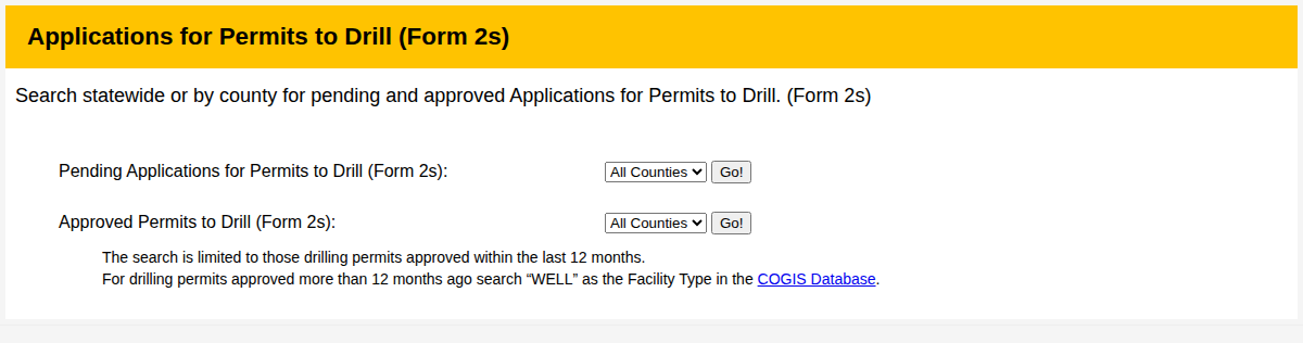
ECMC states both the twelve month limit and the COGIS fallback on the search page itself. [2] That single sentence resolves most failed Colorado permit searches.
Walking the COGIS search for an older permit
For anything older than a year, COGIS is the system of record [2]. Open the facility search, pick WELL at the top of the Facility Type list, and add a county or an API number to narrow it [2]. Submitting the form returns a well list, and clicking the facility type on any row opens that well’s scout card [2]. The permit block sits on the scout card, one block per wellbore [2].
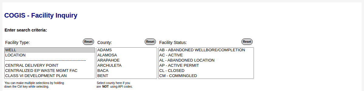
Facility Type set to WELL in the COGIS facility search, the entry point for any permit older than twelve months. [2]
Those records run deeper than most people expect. Take LHI #14-42, a PDC Energy well near Milliken in Weld County [2]. It was spudded on 2 February 2000 and plugged in March 2019, and its scout card still shows permit 990837 expiring on 3 November 2000 [2]. The same block carries the proposed depth of 7,350 feet and the hole direction, listed there as drifted [2].
That per well shape is what makes a permit question expensive at scale. One well is a two minute lookup, but a portfolio of several hundred is several hundred scout cards. No bulk file carries the historical permits behind already drilled wells [3]. If you have the API number already, the API well number lookup guide explains how to read the digits before you search.
Why ECMC’s Permit Map Layer Shows Only Undrilled Wells
The downloadable permits map layer is a live snapshot rather than an archive, and the name does not say so [3]. ECMC publishes a permits shapefile alongside its wells and directional layers on the downloadable data page [3]. Opened up, it holds 777 permit records, and every one of them carries facility status AP, active permit [3].
That uniformity is the tell. A permit row leaves the layer once its well is spudded, so the file only ever describes wells that are approved and not yet drilled. Read as a permit history, it undercounts Colorado’s drilling record by orders of magnitude.
The wells layer confirms the same split from the other direction [4]. Its 34 attribute fields carry the API number, operator, location and facility status [4]. Not one of them is a permit number, an approval date or an expiry [4].
A well that is approved but not yet drilled appears there only as facility status XX, permitted location [4]. Its location qualifier reads Planned rather than Actual, which is the metadata’s own wording for not drilled [4]. That is why a permit question cannot be answered from the bulk wells download at all.
A second published layer holds pending applications, and it answers a different question again [3]. Those rows are applications received but not yet approved, keyed by document number and receipt date rather than by API number [3]. That file held 223 rows when this post was last checked [3].
So the practical rule is short. Use the permits layer for what is approved and waiting to be drilled, the pending layer for the queue, and COGIS for anything already drilled.
What TetraSoft Atlas Adds to a Colorado Well Lookup
TetraSoft Atlas, our subscription platform for oil and gas records, does not replace the ECMC permit search. For permit history the commission’s own systems remain the place to go. What Atlas answers is the question that usually follows the permit lookup, which is what the well went on to do.
Colorado is one of the eight states in TetraSoft Atlas, which together produced 68 percent of US crude oil and 83 percent of US marketed natural gas in 2025 [6]. Atlas is self-serve, with no sales call: you sign up and start a 7-day trial with no credit card [5].
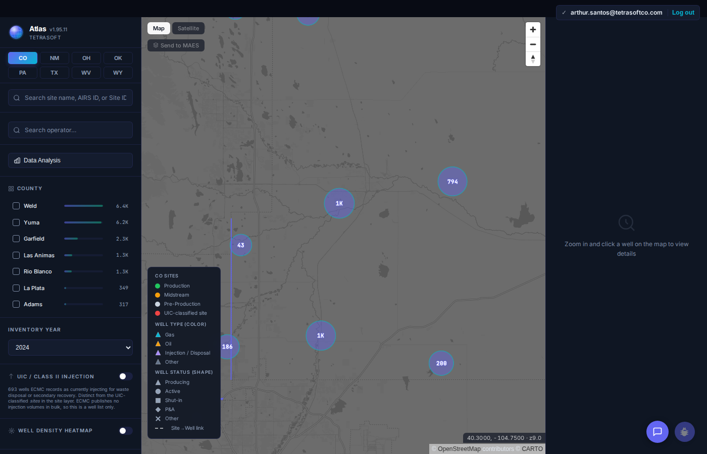
Colorado sites clustered by county, with the county breakdown beside the map. [5]
Atlas carries Colorado wells with their production, emissions, enforcement records and current drilling permits in one view [5]. Each permit shows its approval and expiry date, so the currently valid set reads at a glance. The Compliance tab adds a search that finds Colorado drilling permits by API number, permit number, operator or well name [5].
Roughly 21,000 Colorado spill records sit on the same map as the wells and facilities they belong to [5]. Spills matter to a permit search because they attach to the well you just identified.
What disappears is the reconcile step. ECMC holds the well and permit records while CDPHE holds the emissions inventory, so building one picture from the state portals means working across both [5]. For a wider view of what the agency publishes and where, the COGCC and ECMC data guide covers the maps, permits and wells side by side.
Colorado’s emissions record is unusually detailed, which changes what a well lookup can tell you. Facility level emissions and equipment counts sit beside the well record rather than in a separate filing system [5]. The Colorado oil and gas map covers how the emissions and enforcement layers read together.
Frequently Asked Questions
What is a Form 2 drilling permit in Colorado?
Form 2 is the application to drill, and an approved Form 2 is the drilling permit itself [2]. ECMC labels the approved set “Approved Permits to Drill (Form 2s)” in its permit search [2]. Form 2A is a separate filing covering the planned surface location rather than the wellbore [3].
How long does a Colorado drilling permit stay valid?
Every permit carries an expiration date, and the term has not been constant across the decades [2]. Permits approved recently commonly run about three years from approval, while older ones often ran a single year [3]. A well whose permit lapsed before drilling carries an expired permit status in ECMC’s own well records [2].
Can I download Colorado drilling permits in bulk?
Partly, and only for the current stages of the lifecycle [3]. ECMC publishes a permits shapefile and a separate pending permits shapefile on its downloadable data page, each with its own metadata page [3]. The published permit files stop at approved and pending applications [3]. Historical permits remain a per well lookup in COGIS [2].
How much does TetraSoft Atlas cost?
TetraSoft Atlas comes in three plans priced by team size, billed monthly or annually [5]. For current rates, see the Atlas pricing page [5]. Every plan starts with a seven day free trial, and you can cancel anytime [5].
A Colorado permit search should not depend on knowing which of two ECMC systems holds the record. Start at the commission for the permit, then read the well’s production, emissions and enforcement history on one map in Atlas. Start your free 7-day trial.
References
- Colorado Division of Water Resources, Well Permits search. https://dwr.state.co.us/Tools/WellPermits
- ECMC drilling permit application search and COGIS facility database. Colorado Energy and Carbon Management Commission. https://ecmc.state.co.us/permits/?t=1
- ECMC Downloadable Data and Documents. Colorado Energy and Carbon Management Commission. https://ecmc.colorado.gov/data-maps-reports/downloadable-data-documents
- ECMC COGIS wells shapefile metadata. Colorado Energy and Carbon Management Commission. https://ecmc.state.co.us/COGIS_Help/GIS_Help/Documents/well_meta.htm
- TetraSoft Atlas, Colorado oil and gas dataset and product features. https://tetrasoftco.com/atlas-landing.html#pricing
- U.S. Energy Information Administration, crude oil field production and natural gas marketed production by state, annual 2025, accessed 23 September 2026. https://www.eia.gov/dnav/pet/pet_crd_crpdn_adc_mbbl_a.htm; https://www.eia.gov/dnav/ng/ng_prod_sum_a_EPG0_VGM_mmcf_a.htm
This post is for informational purposes only and does not constitute legal or compliance advice. Consult qualified legal counsel or a compliance professional for guidance specific to your operations and jurisdiction.
Colorado permit router
Find the system that holds your well permit
Two Colorado agencies issue records called a well permit, across three separate systems. Answer two questions and this names the one holding yours, and what to search it by.
Leave blank if you do not know. The twelve month window is rolling, so the answer depends on today's date as well as the permit's.
Comments
0Share your thoughts. All comments are moderated before appearing.
No comments yet. Be the first to share your thoughts!