A deal priced on stale well data can buy a lease that has expired, or pursue an operator who no longer answers for the well. Both risks hide in public records, one at the state regulator and one at the county courthouse. Knowing which office answers which question before title work starts saves a wasted trip and a bad assumption.
A landman is the specialist who negotiates drilling rights with landowners and checks land records and mineral ownership [1]. Oil and gas well data is the state regulator’s public record of a well: operator, status, permits, production and identifying numbers. Where the minerals are privately owned, deeds and leases are recorded by county instead. The problem is that neither office answers both of a landman’s questions: what a well is doing, and who owns the minerals under it.
Texas is the worked example, with about 1.2 million API numbers, plugged wells included [2]. An API number is the number agencies use to identify and track each well [3].
The Texas regulator is the Railroad Commission of Texas (RRC), which, despite its name, no longer regulates railroads and oversees the state’s oil and gas industry [4]. The Commission draws the same line on its frequently asked questions (FAQ) page on royalties, where it answers common public questions [5]. There it points lease questions to “the courthouse of the county where the land is located.” [5]
Readers in the other seven states, New Mexico, Oklahoma, Colorado, Wyoming, Pennsylvania, West Virginia and Ohio, will find their agency’s well data below. Together the eight produced 68% of the crude oil and 83% of the marketed gas of the United States (US) in 2025 [6]. TetraSoft Atlas, our subscription platform of public well, production and enforcement records, covers all eight states [2]. We plan to expand Atlas to every US state.
The guide is written for landmen, and for the title and acquisition teams who need the well side of a deal fast. It covers, in order, what public well records answer, where each state keeps them and how to trace a well’s operator history. It then shows where county courthouse records take over, and how to tell whether a lease is held by production. It ends with how TetraSoft Atlas puts a well’s regulator records on one screen.
Quick Answer: State well records answer a landman’s operational questions. They cover the operator of record, status, production history, drilling permits, and the well’s identifying and lease numbers. In Texas, a deed, lease or other real property instrument must be recorded in a county where part of the land lies [7]. TetraSoft Atlas joins the well side in eight states and carries no ownership or title data [2].
What Public Well Records Answer for a Landman
Public well records answer six questions a landman asks before title work starts. They say who runs the well, whether it is producing or shut in, what it produced, what was permitted and how it is numbered. The American Petroleum Institute (API) describes a landman as a specialist who “negotiates with landowners” for drilling rights [1]. API is the oil and gas industry’s national trade association [8].
The same definition adds that a landman “conducts research on land titles and mineral ownership.” [1] The well side of that research is filed with the state, and the Commission charges nothing to access its online production and permit records [5].
In Texas, the API number on a well file is unique to each wellbore, and old wells drilled before API numbering got dummy numbers [9].
The second column names the kind of record that answers each question in every state covered. The third gives the Texas record as the worked example.
| Landman question | Record that answers it, any state | Texas example | Where it is kept |
|---|---|---|---|
| Who operates the well now? | Operator of record on the well file | Form P-4, which establishes the operator of a lease or well | State oil and gas regulator |
| Who operated it before? | Change-of-operator filings (in Ohio, well-transfer notices), where they were filed | Earlier P-4 filings that changed the operator (P-4s are also filed for gatherer, purchaser and name changes) | State oil and gas regulator |
| Is it producing? | Well status and production reports | Well status and monthly production reports | State regulator; Oklahoma production at the Tax Commission |
| What has it produced? | Reported production history | Production Data Query (PDQ), the Commission’s online production search, January 1993 to present, reported by lease | State regulator; in Oklahoma, the Tax Commission |
| Was it permitted, and when? | Drilling permit records | Drilling permit records, in the Commission’s Drilling Permit Query, searchable by API number, operator, lease or county | State oil and gas regulator; also the Bureau of Land Management (BLM), manager of federal onshore minerals, on federal land |
| Which numbers identify it? | API number, plus the state’s own lease or permit number (in Oklahoma, the Tax Commission’s production unit number, or PUN, the lease number it publishes production under) | API number and lease number | State oil and gas regulator; Oklahoma Tax Commission for PUNs |
| Who owns the minerals? | Deeds and other recorded instruments | Deeds and other recorded instruments | County clerk or recorder, for privately owned (fee) minerals |
| What does the lease say? | The recorded lease or a memorandum of it, plus assignments | The recorded lease, or a recorded memorandum giving notice of it, plus recorded assignments | County on private (fee) land, or the parties for an unrecorded lease |
Two cautions apply to the production row. “In Texas, production is reported by each oil and gas lease rather than individual well,” the Railroad Commission says [10]. An oil lease can hold numerous wells and reports them as one volume, while a gas lease contains one gas well [10].
A multi-well oil lease therefore has no reported per-well production volume. The Commission lists Form W-10 as its Oil Well Status Report [11]. Each oil well’s annual or semi-annual status test is filed on that form; the tests are not reported production.
Production Data Query (PDQ) covers January 1993 onward, and earlier records are requested from the Commission [5].
Where to Find Well Records Outside Texas
Outside Texas, the same well questions go to each state’s own regulator, linked below.
| State | Regulator | Where to look up a well |
|---|---|---|
| New Mexico | Oil Conservation Division | Oil Conservation Division data |
| Oklahoma | Oklahoma Corporation Commission; production at the Oklahoma Tax Commission | Oil and gas data files; gross production by PUN |
| Colorado | Energy and Carbon Management Commission | Facility inquiry, by API number, operator or legal location |
| Wyoming | Wyoming Oil and Gas Conservation Commission | Data Explorer |
| Pennsylvania | Department of Environmental Protection | PA Oil and Gas Mapping (PA for Pennsylvania), the department’s well map, by permit number, operator, county or municipality |
| West Virginia | Department of Environmental Protection, Office of Oil and Gas | Search Oil and Gas Database, with well and permit searches |
| Ohio | Ohio Department of Natural Resources | Oil & Gas Well Locator map and Oil & Gas Well Database |
The Oklahoma Tax Commission publishes production by lease, under the Production Unit Number (PUN) it assigns [12]. On federal land, the Bureau of Land Management manages the federal government’s onshore mineral estate [13].
Operator History Lives in the P-4 Filings
The current operator is one field, and the operator history is the change-of-operator filings in a stack of P-4 forms. The Commission’s P-4 instructions require a new P-4 for a change of operator, and both operators sign it [14]. Regulatory responsibility “does not transfer until the P-4 has been approved,” so the approved form, not the sale date, marks who answers to the Commission [14].
That distinction matters when a runsheet shows an assignment and the well record still names the seller. Both can be correct on the same day. To read the number that ties these filings to one wellbore, see API Well Number Lookup: What It Is and How to Read One.
Where County Courthouse Records Take Over
The Railroad Commission says it has no authority over “lease and royalty matters,” including leasing and the payment of royalties [5]. A well record can therefore name the operator without saying anything about who owns the minerals under it.
Under Texas law, land ownership includes two distinct estates, the surface estate and the mineral estate [15]. In many areas with extensive historical oil and gas development, “it is common” for different people to own the two [15]. That split, called severance, happens when an owner sells the surface and keeps all or part of the minerals, or, less commonly, the reverse [15]. Once the estates are severed, the surface deed is no longer the mineral title, so a landman runs the mineral chain separately.
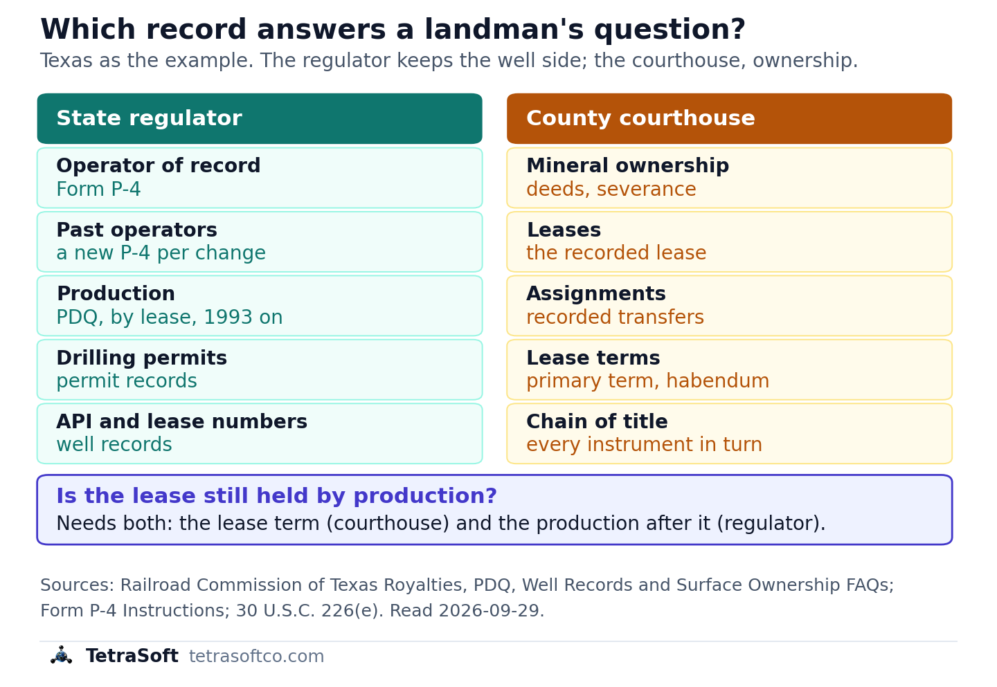
Which record answers which landman question, with Texas as the example: the well side is filed with the state regulator, the ownership side at the county courthouse.
Is the Lease Held by Production? It Takes Both Records
Whether a lease is still alive is a question neither office answers alone. A federal oil and gas lease, for example, starts with a fixed primary term [16]. It then continues “so long after its primary term as oil or gas is produced in paying quantities.” [16] Private leases set their own terms, so the lease itself decides which clauses apply.
Texas production is public, reported monthly, posted online with a two-month lag and substantially complete after about six months [10]. The habendum clause sets how long a lease lasts. A landman who reads it also checks production, but an RRC lease can be a pooled unit of several tracts, not one lease instrument. Savings clauses, such as shut-in royalty or continuous-operations clauses, can also keep a lease alive, so the whole lease gets read.
What surprised us is how often that production check means opening a second agency system after the courthouse visit. Whether production was in paying quantities is a legal question for qualified counsel, not a data lookup.
This post is for informational purposes only and does not constitute legal or compliance advice. Consult qualified legal counsel or a compliance professional for guidance specific to your operations and jurisdiction.
How TetraSoft Atlas Puts the Well Side on One Record
TetraSoft Atlas shows each well’s operator of record and status in eight states, adds production in seven, and leaves ownership to the courthouse [2]. For mineral ownership, title, lease terms and lease boundaries, you still use the county record and your land or title software [2]. In seven states, Atlas puts the operator of record, status and production on one record, a site record in Colorado [2].
Pick a state and a question in the finder below to see which record answers it and whether Atlas carries that record there.
The coverage differs by state, and each difference is on the record. Texas production in Atlas is the lease total split evenly across the wells on the lease, because the Commission reports by lease [2]. On a multi-well oil lease, read each well’s status beside that figure, since an even split can credit a shut-in well.
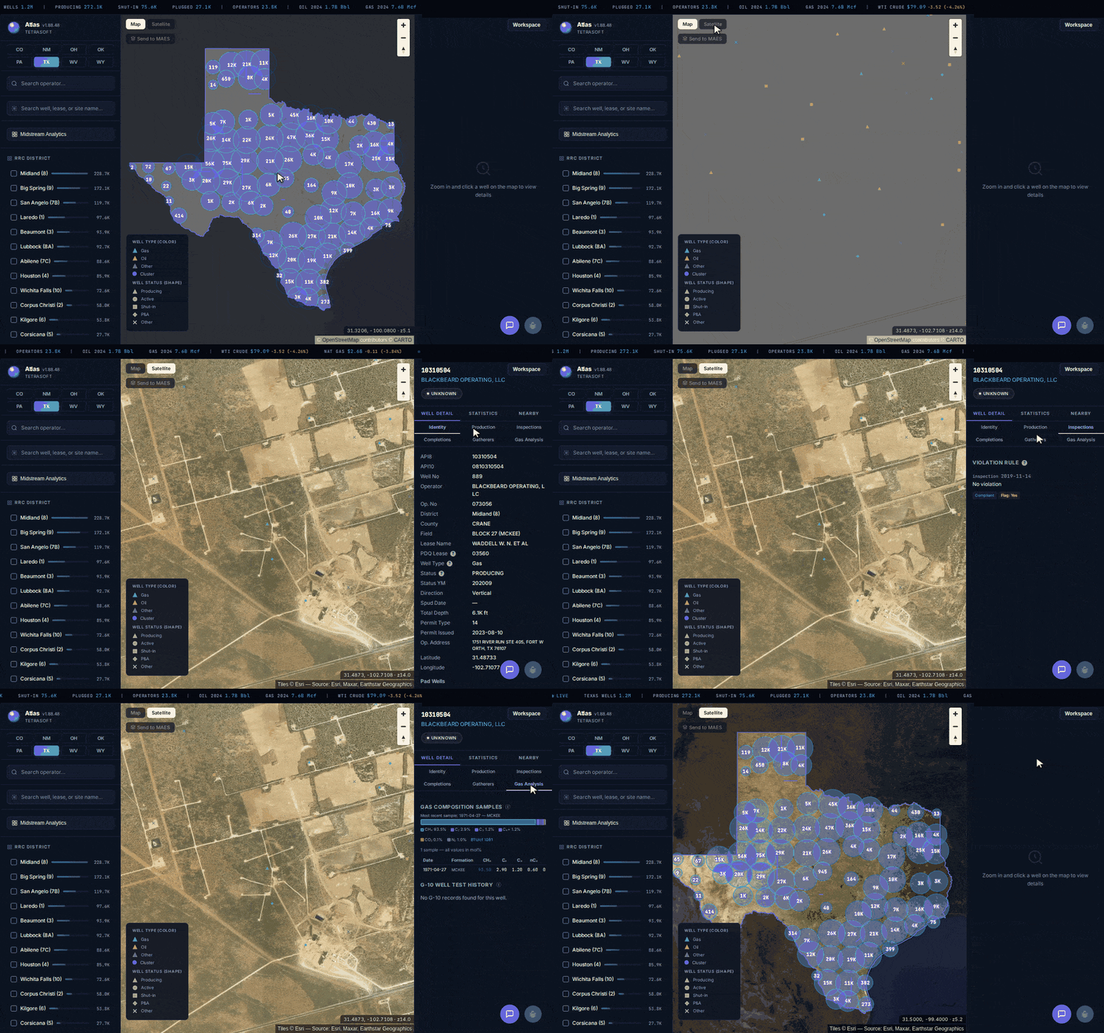
TetraSoft Atlas in Texas: the statewide map, satellite view, then one well’s record, tab by tab.
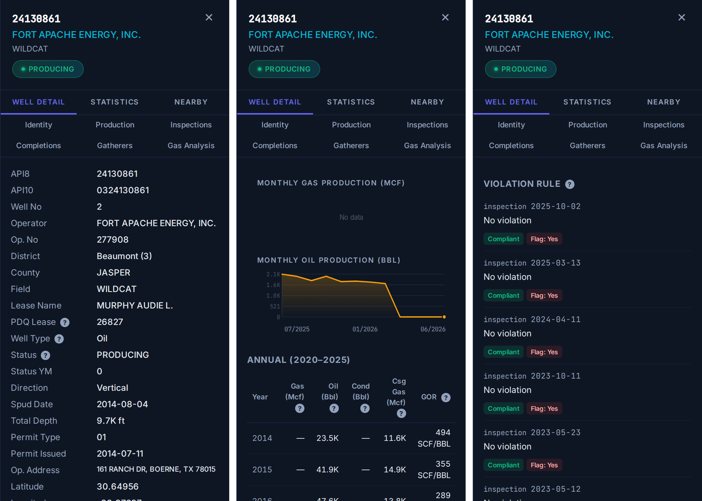
The well side of a landman’s question in one Texas record in TetraSoft Atlas: operator of record and lease, permit and spud dates, production (the lease total split evenly across the lease’s wells, not the well’s own reported volume) and state inspections.
Atlas shows Ohio production as annual totals per well [2]. Oklahoma production is not in Atlas [2].
Atlas searches by API number in every covered state, by lease name in Texas, by well name in six others and by site in Colorado [2].
Atlas search by operator works in every state, and in Colorado it filters the site list [2]. For permits, Atlas lists Colorado’s and shows each well’s permit record in its panel in Texas, New Mexico, Oklahoma and Wyoming [2]. Texas and Oklahoma permits are also a map layer, and Atlas shows no permits in Pennsylvania, West Virginia or Ohio [2]. The free alternative is each state’s own portal, repeated per state and per well, with the joins done by hand.
Atlas covers Texas, New Mexico, Oklahoma, Colorado, Wyoming, Pennsylvania, West Virginia and Ohio [2]. Until Atlas reaches more states, a nationwide data vendor covers wells beyond these eight.
For how Atlas compares with other oil and gas data platforms, see Oil and Gas Data Analytics Platforms: How to Choose One. For the logs in a well’s file, Well Log Lookup: Find Logs for Any US Oil or Gas Well shows where each state keeps them.
Frequently Asked Questions
What software do landmen use for well data?
Land management software is built to track leases, ownership, interests and chain of title. Well data comes from each state regulator, through its own portals or a platform that joins them. TetraSoft Atlas joins them in eight states from agency records alone; it holds no mineral ownership or title records and does not replace land software [2].
How do I find who owns the mineral rights under a well?
Not from its well record. A well record names the operator, not the mineral owners, and Texas minerals are often owned apart from the surface [15]. Privately owned minerals are traced through instruments recorded in the county where the land sits. Royalty owners can start with the division order guide, Division Order: What It Is and How to Check the Decimal.
Are oil and gas leases public record?
On private land, at the county, where the lease or a memorandum of it was recorded. In Texas, to be effectively recorded, a real property instrument must be recorded in a county where part of the property lies [7]. Ohio county recorders record leases and lease memoranda under Ohio Revised Code section 317.08, the statute listing what they record [17]. In Ohio, an unrecorded oil and gas lease is invalid except between the parties, unless its holder is in actual and open possession [18].
How do I find every well on a lease in Texas?
Search by the lease number. The Railroad Commission says that with a lease or API number, you need not add the field or lease name to a well records search [19]. In TetraSoft Atlas, a Texas lease-name search caps results at 15 wells statewide, so it is not a full list for a larger lease [2].
How much does TetraSoft Atlas cost?
Atlas plans scale with the number of seats, and the listed plans start with a 7-day free trial that needs no credit card [2]. Teams larger than 15 seats contact TetraSoft [2]. Current prices are on the Atlas pricing page.
For a landman, the well side of a title job often means another agency portal after the courthouse. TetraSoft Atlas puts a well’s operator of record and status on one record in each covered state, with production alongside except in Oklahoma [2].
References
- American Petroleum Institute, The Real-Life Landman. https://www.api.org/reallandman
- TetraSoft Atlas, eight-state oil and gas dataset read September 2026. https://www.tetrasoftco.com/atlas-landing.html
- West Virginia Department of Environmental Protection, API Number Explanation. https://dep.wv.gov/oil-and-gas/GI/Documents/API%20Number%20Explanation.pdf
- Railroad Commission of Texas, About Us. https://www.rrc.texas.gov/about-us/
- Railroad Commission of Texas, Royalties FAQ on leases, royalty payments and records. https://www.rrc.texas.gov/about-us/faqs/royalties-faq/
- U.S. Energy Information Administration, crude oil field production and natural gas marketed production by state, annual 2025. https://www.eia.gov/dnav/pet/pet_crd_crpdn_adc_mbbl_a.htm; https://www.eia.gov/dnav/ng/ng_prod_sum_a_EPG0_VGM_mmcf_a.htm
- Texas Property Code section 11.001, recording in the county where the property is located. https://texas.public.law/statutes/tex._prop._code_section_11.001
- American Petroleum Institute, About API. https://www.api.org/about
- Railroad Commission of Texas, Data Sets Available for Download. https://www.rrc.texas.gov/resource-center/research/data-sets-available-for-download/
- Production Data Query System FAQs, Railroad Commission of Texas (PDQ), lease production reporting. https://www.rrc.texas.gov/about-us/faqs/oil-gas-faq/production-data-query-system-faqs/
- Railroad Commission of Texas, Oil and Gas Forms. https://www.rrc.texas.gov/oil-and-gas/oil-and-gas-forms/
- Oklahoma Tax Commission, Gross Production. https://oklahoma.gov/tax/businesses/gross-production.html
- Bureau of Land Management, About the BLM Oil and Gas Program. https://www.blm.gov/programs/energy-and-minerals/oil-and-gas/about
- Railroad Commission of Texas, Form P-4 Instructions. https://www.rrc.texas.gov/media/kx0hcdrw/p-4-ins.pdf
- Railroad Commission of Texas, Oil and Gas Exploration and Surface Ownership FAQ. https://www.rrc.texas.gov/about-us/faqs/oil-gas-faq/oil-gas-exploration-and-surface-ownership/
- 30 U.S.C. 226(e), Mineral Leasing Act, primary terms. https://www.law.cornell.edu/uscode/text/30/226
- Ohio Revised Code section 317.08, records kept by the county recorder. https://codes.ohio.gov/ohio-revised-code/section-317.08
- Ohio Revised Code section 5301.09, recording of oil and gas leases. https://codes.ohio.gov/ohio-revised-code/section-5301.09
- Railroad Commission of Texas, Well Records FAQs on searching well records. https://www.rrc.texas.gov/about-us/faqs/oil-gas-faq/well-records-faqs/
Interactive tool
Which record answers your question?
Pick the state and the question. The finder names the office that holds the record, where to look for free, and whether TetraSoft Atlas carries that record in the state.
Answered by
Both records
Is the lease still held by production? (Texas)
- Free place to look
- The recorded lease at the courthouse, plus RRC Production Data Query, reported by lease from January 1993
- In TetraSoft Atlas
- In part The production half only (production tab, monthly: an oil lease total split evenly across its wells (a gas lease has one well)). The lease clause stays at the courthouse.
See what TetraSoft Atlas holds
Atlas coverage read from the Atlas code, October 2026. Atlas holds no mineral ownership, title, lease terms or lease boundaries in any state. Texas sources are the Railroad Commission's own forms and FAQs; other states point to the agency's official well map. Nothing you pick leaves your browser.
Comments
0Share your thoughts. All comments are moderated before appearing.
No comments yet. Be the first to share your thoughts!