The WVDEP Office of Oil and Gas is the West Virginia regulator that permits, inspects, and records every oil and gas well in the state [1]. Its records reach 167,332 wells, of which 73,121 are producing [2]. A West Virginia oil and gas well search is harder than it should be, because the office publishes six separate search tools rather than one [1]. Wells, permits, enforcement, injection wells, injection volumes, and the map each answer a different question and do not talk to each other [1]. What the injection classes themselves mean, and which one a given well falls into, is covered in UIC Well Classes: Class II, Class VI, and Where to Look. TetraSoft Atlas, a subscription data platform, joins those records to one map and adds the air and emissions data those tools never carry [2].
Quick Answer: The WVDEP Office of Oil and Gas publishes six search tools covering wells, permits, enforcement, UIC wells, injection volumes, and a map. The Well Search is the one to start with, and it finds any of West Virginia’s 167,332 wells by API number, operator, county, or surface owner. Air permits and reported emissions sit outside all six, which is the gap Atlas fills.
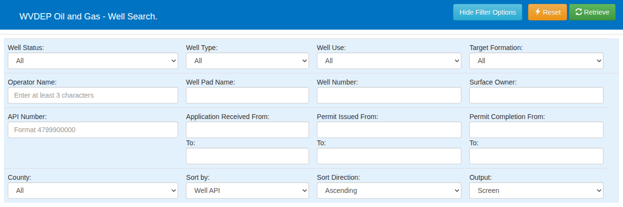
The WVDEP Well Search form. Surface owner sits in the top row of text fields, next to well number. [1]
What the WVDEP Well Search Actually Does
The Well Search is the Office of Oil and Gas tool that returns individual well records [1]. It is more capable than its plain form suggests. It searches by API number, well number, well pad name, operator name, and surface owner [1]. Date ranges narrow results by when an application was received, a permit issued, or a permit completed [1].
The dropdown filters are where the detail lives. The form offers 14 well statuses, 7 well types, 16 well uses, and 119 target formations across all 55 counties [1]. Results sort nine ways and export straight to Excel [1].
Two of those filters repay a close look. The status list includes Never Drilled, Reverted Mine Vent, Duplicate API, and Unlocatable, which is a permitted well the state cannot confirm a position for [1]. The well use list runs to Coal Bed Methane, Gob Well, Brine Disposal, House Gas, and Solution Mining [1].
Start From the API Number When You Have It
An API number resolves to exactly one wellbore, so it is the fastest route through any of the six tools. WVDEP publishes its own explanation of how West Virginia API numbers are built [1]. If the digits are unfamiliar, the API well number lookup guide breaks them apart.
Which WVDEP Tool Answers Which Question
Pick the tool by the question, because none of the six answers more than its own slice. The Well Search covers well identity and status, and the others each sit one click away on the same Search Oil and Gas Database page [1].
| Your question | The WVDEP tool |
|---|---|
| Where is this well and what is its status? | Well Search |
| Has a West Virginia drilling permit been issued or applied for? | Permit Search |
| Has this operator been cited? | Enforcement Search |
| Is this an injection well? | UIC Well Search |
| How much has been injected? | UIC Injection Volumes |
| Show me everything on a map | Oil and Gas Map Search (TAGIS) |
A seventh tool is listed and not working [1]. The page states that the Operator Agent search tool “is currently unavailable” and points to a spreadsheet for operator and agent contacts instead [1]. Assembling one well’s full story means running several of these in sequence and matching results by API number yourself.
Abandoned and Orphaned Wells Have Their Own Map
West Virginia runs its plugging program on a separate mapping tool, apart from the main WVDEP map search (TAGIS) [1]. The program is funded through the Infrastructure Investment and Jobs Act and the Inflation Reduction Act, each with its own page [1]. Anyone tracing abandoned gas wells in West Virginia needs that tool as well as the Well Search.
West Virginia Gas Production Data Comes From Separate Filings
For most well types, West Virginia gas production data reaches WVDEP once a year, with reports due March 31 [4]. Horizontal 6A wells have reported quarterly instead since June 8, 2018 [4]. WVDEP posts one statewide production data set per year, starting in 1985 [4].
Those filings sit outside the Well Search, so WV well production data lives apart from each well’s record [1]. Atlas attaches WVDEP production to the well itself, with gas, oil and water totals year by year on its Production tab [2]. Start a free trial from the Atlas page to open any West Virginia well’s production.
What No WVDEP Oil and Gas Tool Shows You
Air quality is the gap, and it sits inside the same department. The Office of Oil and Gas tools return wells, permits, enforcement, and injection, and none of them reach air permits or reported emissions [1]. A well’s greenhouse-gas reporting sits with the EPA, in a federal program the state pages do not link into.
Atlas joins the WVDEP oil and gas records with WVDEP Division of Air Quality permits, EPA facility and greenhouse-gas reporting, and lab gas analyses [2]. West Virginia carries 19 facilities reporting to the EPA Greenhouse Gas Reporting Program, with CO2e by year from 2016 [2]. EPA is reconsidering Subpart W reporting requirements through 2034, so availability for future reporting years is uncertain. The air-permit layer adds state permit facilities and G70 application equipment with potential-to-emit figures [2].
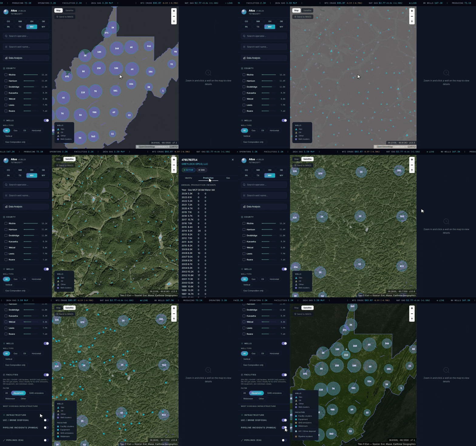
One well, then the whole state: production, gas composition, air-permitted facilities, injection wells and pipeline incidents, from records the Office of Oil and Gas splits across separate tools. [2]
What Paying Buys That Six Free Tools Cannot
The free tools answer one record at a time, and Atlas answers across the state at once on one WV oil and gas map.
| For a West Virginia well | WVDEP tools | Atlas |
|---|---|---|
| Identity, status and production | Well Search plus separate reporting filings | On one record |
| Injection wells | Separate UIC tool | On the same map |
| Air permits and equipment | Different WVDEP office | On the same map |
| Reported emissions | Not a WVDEP dataset | EPA GHGRP and FRS, beside the well |
| Gas composition | Not published per well | Where samples exist |
| Wells outside West Virginia | No | Seven more states on one map |
| Cost and account | Free, no login | From $99 a month, self-serve, 7-day trial with no credit card |
| Drilling permits and enforcement | Permit Search and Enforcement Search | Not carried; WVDEP stays the source |
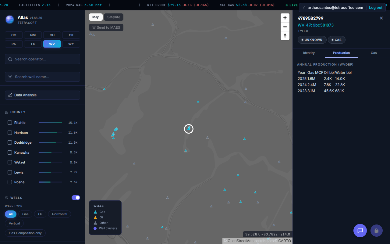
A West Virginia well’s WVDEP-reported production, on the record rather than in a separate filing. [2]
Statewide, Atlas holds 3,217 operators, 2,085 facilities, and 15 gas plants for West Virginia [2]. Its production records total nearly 33 billion Mcf of gas and 203 million barrels of oil [2]. Ritchie, Harrison, and Doddridge counties lead the well count at 15,082, 11,550, and 11,035 [2].
The two tools are authoritative for different things. Atlas refreshes on a schedule, so WVDEP stays the system of record for a well’s official status today [2]. When a filing or a transaction turns on the official record as of today, check the state tool.
Atlas earns its place on the work the free tools make slow: a portfolio of wells, an operator’s whole footprint, or any question where air permits and emissions have to sit beside the well record. That is the view the six WVDEP tools cannot assemble for you.
West Virginia is one of eight states carrying this view, alongside neighbouring Pennsylvania [2]. The same approach for that state is covered in the PA DEP oil and gas mapping guide.
Frequently Asked Questions
Is the WVDEP oil and gas search free?
Yes. Every Office of Oil and Gas search tool is public and needs no account [1]. The Well Search also exports its results to Excel, so a county or operator list downloads in one step [1].
Can I search WVDEP records by surface owner?
Yes, the Well Search carries a surface owner field [1]. It sits alongside operator name, well pad name, well number, and API number [1]. That makes it one of the few state well searches a landowner can drive without an API number.
What does the Unlocatable well status mean in WVDEP records?
Unlocatable is one of 14 well statuses in the Well Search dropdown [1]. It sits beside Never Drilled, Reverted Mine Vent, and Duplicate API in the same list [1]. The label marks a permitted well with no confirmed position, so it will not map reliably.
Where do I find West Virginia well production data?
Production reaches the Office of Oil and Gas through its own reporting requirements rather than the Well Search form [1]. Operators of horizontal 6A wells file quarterly, and the rest report annually [1]. Those 6A wells fall under the Natural Gas Horizontal Well Control Act, W.Va. Code §22-6A [1]. West Virginia wells reported 3.27 billion Mcf of gas in 2024 [2].
Can I download WVDEP well records in bulk?
Yes, the Well Search output selector offers Excel as well as on-screen results [1]. A filtered county, operator, or formation result set therefore downloads in one step [1]. WVDEP also runs an open data portal publishing its oil and gas well layers for GIS use [3].
Start a WV oil and gas well search on the WVDEP Well Search when you need one well from the source. Open Atlas when the question spans many wells, or needs air and emissions data beside them. Atlas carries 167,332 West Virginia wells with production, air, and emissions records joined, across eight states in one view [2]. Start your free 7-day trial.
This post is for informational purposes only and does not constitute legal or compliance advice. Consult qualified legal counsel or a compliance professional for guidance specific to your operations and jurisdiction.
References
- West Virginia Department of Environmental Protection, Office of Oil and Gas, Search Oil and Gas Database and Well Search, dep.wv.gov, queried July 28, 2026
- TetraSoft Atlas, West Virginia dataset, queried July 28, 2026
- West Virginia Department of Environmental Protection, WVDEP Open Data portal, data-wvdep.opendata.arcgis.com, queried July 28, 2026
- West Virginia Department of Environmental Protection, Office of Oil and Gas, Database Information (production data) and Quarterly Reporting Requirements Horizontal 6A Wells, dep.wv.gov, queried September 28, 2026. https://dep.wv.gov/oil-and-gas/databaseinfo/pages/default.aspx; https://dep.wv.gov/oil-and-gas/rr/Pages/Quarterly-Reporting-Requirements%20-%20Horizontal%20Wells.aspx
Comments
0Share your thoughts. All comments are moderated before appearing.
No comments yet. Be the first to share your thoughts!