Checking a lease, valuing a producing asset or screening a site for a setback all start from the same place: a state’s well records. Read them wrong and a lease looks active while its wells sit idle, or a county looks busier than it is. Counting rules alone can move one state’s well total by tens of thousands of wells.
Oil and gas well data is the set of records a state regulator keeps for every well it permits. Operators file them on forms at each stage of the well’s life, from the permit to the plugging record. The difficulty is that each state uses its own forms, agencies and status codes for the same facts.
For landmen, royalty owners, analysts and deal teams, this post first lists the fields a well record holds and the form each comes from. It then names the agency that keeps the record in each state and explains why two well counts disagree. It closes with how to check whether a well still produces and how to read a whole record in one place. Texas is the worked example for forms, because it has the most well records of any state covered here, about 1.2 million by our count [1].
Instead of eight agency searches in eight formats, TetraSoft Atlas, our subscription map of well records, opens the well records of eight states on one screen. They are Texas, New Mexico, Oklahoma, Colorado, Wyoming, Pennsylvania, West Virginia and Ohio. Together they produced 68% of US crude oil and 83% of US marketed natural gas in 2025 [2]. We plan to expand Atlas to every US state [3].
Quick Answer: A well record is assembled from filings across a well’s life: permit, completion report, production reports, operator changes and plugging. Production is filed monthly in most states. Pennsylvania, Ohio and West Virginia take yearly reports from conventional wells, but monthly or quarterly reports from horizontal or unconventional wells. The API number, a well identifier first standardised by the American Petroleum Institute, encodes state and county and ties a wellbore’s filings together. Two databases count the same state differently because states define status differently, and some keep permits that were never drilled.
What an Oil and Gas Well Record Contains, Field by Field
A well record grows in stages, because each filing adds fields the earlier ones could not know. The table lists the fields analysts use most, with the Texas form each is filed on as a worked example.
The Railroad Commission of Texas (RRC) is the state’s oil and gas regulator, and its forms page lists the forms named below. It takes the permit to drill on Form W-1 and completion reports on Form W-2 for oil or G-1 for gas [4]. Monthly production goes on Form PR, and the plugging record on Form W-3 [4].
| Field | What it tells you | Filed on (Texas example) |
|---|---|---|
| API number | The well’s identifier | Assigned by the RRC during drilling permitting (W-1) |
| Operator | The company responsible for the well today | Permit (W-1); changes filed on Form P-4 |
| Lease or unit | The tract, or pooled group of tracts, the well produces for | Permit (W-1) |
| Field and county | The named producing area and the county | Permit (W-1) |
| Surface location | Where the well enters the ground, with its datum (the survey reference its coordinates use) | Permit (W-1) |
| Bottomhole location | Where the wellbore ends underground, far from the surface point on a horizontal well | Permit attachment (W-1D or W-1H); as drilled, from the directional survey |
| Spud date | The day drilling started | Reported to the RRC when drilling begins; repeated on the completion report (W-2 or G-1) |
| Completion date and formation | When the well was readied to produce, and the rock layer it produces from | Completion report |
| Total depth and true vertical depth | How far the hole runs along its path, and how deep it reaches straight down | Completion report |
| Well type and trajectory | Oil, gas, injection or disposal; vertical, directional or horizontal | Permit (W-1); trajectory confirmed by the directional survey |
| Lateral length | The length of the horizontal section on a horizontal well | No form field; measured from the as-drilled plat or directional survey |
| Status | Producing, shut in, plugged, orphaned and similar | Changes over the well’s life |
| Production | Monthly oil and gas volumes; Texas reports them by lease | Monthly production report (PR) |
| Inspections | Dates and results of the regulator’s field visits | Regulator’s inspection records |
| Violations and enforcement | Notices of violation and the actions that followed | Regulator’s enforcement records |
| Plugging date | When the hole was sealed with cement and retired | Plugging record (W-3) |
Fields as filed in Texas; other states collect similar information on their own forms and records.
Outside Texas, the same fields are filed with each state’s own regulator, under its own form numbers. Readers in Oklahoma, Pennsylvania, Ohio, West Virginia, New Mexico, Colorado and Wyoming will find their agency linked in the next section’s table.
Emissions inventories sit outside the well record, though Texas and New Mexico regulators collect vented and flared gas volumes. In Colorado, emissions go to ONGAEIR (Oil and Natural Gas Annual Emission Inventory Reporting), the yearly emissions inventory operators file with the state [5]. It is run by the Air Pollution Control Division of the Colorado Department of Public Health and Environment (CDPHE), the state’s health and environment agency [5].
Federally, they go to the Greenhouse Gas Reporting Program (GHGRP) of the US Environmental Protection Agency (EPA), the national environmental regulator [6]. Its Subpart W rule covers petroleum and natural gas facilities emitting 25,000 metric tons or more of carbon dioxide equivalent (CO2e) a year [6].
For onshore production, one facility is all of an operator’s wells and equipment in one basin [7]. EPA has proposed suspending Subpart W reporting until 2034, but that proposal is not final [8]. The Subpart W Proposed Rule: Is GHGRP Reporting Still Required? post covers what that program asks of operators today.
The API Number Joins Every Field
The API number is the main join key: a well’s completion, plugging and log filings meet its permit through it. Texas and Oklahoma report production by lease, not by API number.
The API Well Number Lookup: What It Is and How to Read One post explains its digits, and the Well Log Lookup: Find Logs for Any US Oil or Gas Well post shows how logs attach to it. The key has gaps even at the source. The Texas regulator’s map guidance warns that “while all API numbers are attached to wells, not all wells have API numbers.” [9]
The gap is age. The American Petroleum Institute published its well numbering scheme in 1966 [10]. RRC gives “Dummy API numbers” to “old wells drilled prior to implementation of the API numbering technique.” [11] RRC adds that it “continues to research and assign API numbers to wells lacking API numbers.” [9]
A wellbore is one drilled hole, and a completion is one interval of it opened to produce from one formation. One wellbore can therefore carry several completions, which is why “how many wells” can be answered by counting records, completions or wellbores. The platform comparison in Oil and Gas Data Analytics Platforms: How to Choose One shows how far those counts drift apart in Texas.
Operator History Shows Who Has Run the Well
The operator field names the current operator of an oil well, not who ran it before. In Texas the history sits in Form P-4, the Producer’s Transportation Authority and Certificate of Compliance [4]. A new P-4 is filed when a lease changes operator, so the filings trace who has held it. That history matters in due diligence, because plugging obligations follow the operator of record.
For landmen and royalty owners, a well record answers who operates this oil well, what it has produced and whether it is still active. It does not record who owns the minerals or the terms of a lease, though a Texas permit plat outlines the lease. RRC’s Royalties FAQ lists “lease and royalty matters (including leasing, payment of royalties and the right to receive royalties)” among areas outside its authority [12]. For an existing lease, RRC points readers to “the courthouse of the county where the land is located.” [12]
Title and ownership work therefore starts at the county courthouse, and the well record confirms the operator and production behind it. RRC adds that its production records “may be helpful in determining your interests.” [12] Checking the decimal on a royalty statement is covered in Division Order: What It Is and How to Check the Decimal.
Who Keeps Oil and Gas Well Data in Each State
In each state below, one conservation or environmental regulator keeps the well record, and in most of them it also keeps production reports. Oklahoma splits the record across two agencies, the Corporation Commission and the Tax Commission. Wells sit with the Oklahoma Corporation Commission, while the Oklahoma Tax Commission (OTC) holds production by lease “using the OTC assigned Production Unit Number (PUN).” [13] A PUN is the identifier the Tax Commission assigns to a producing lease to report its volumes [13].
| State | Agency that keeps the well record | Wells held in Atlas |
|---|---|---|
| Texas | Railroad Commission of Texas (RRC) | 1,213,035 |
| Oklahoma | Oklahoma Corporation Commission (OCC) | 455,962 |
| Pennsylvania | Department of Environmental Protection (DEP) | 279,541 |
| Ohio | Department of Natural Resources (ODNR) | 242,399 |
| West Virginia | Department of Environmental Protection (WVDEP) | 167,465 |
| New Mexico | Oil Conservation Division (OCD) | 142,393 |
| Wyoming | Oil and Gas Conservation Commission (WOGCC) | 130,877 |
| Colorado | Energy and Carbon Management Commission (ECMC) | 124,576 |
Wells per state held in TetraSoft Atlas, read 30 September 2026; Wyoming’s figure is the WOGCC Active Wells layer plus the agency’s plugged-and-abandoned wells. [1]
Each regulator publishes in its own format and on its own schedule. Texas releases its full wellbore file weekly in ASCII and in EBCDIC, an old IBM text format many modern tools cannot open directly [11]. Each state’s own search tool has a step-by-step guide: RRC Wellbore Query for Texas, OCC Oklahoma Oil and Gas, PA DEP Oil and Gas Mapping, the ODNR Well Locator, WVDEP Oil and Gas, NMOCD Well Search, COGCC (Now ECMC) Oil and Gas Data and WOGCC Well Search.
Why Two Well Counts Disagree, and How to Check Them
Two well counts for one state can disagree because each state defines status its own way, and some registers keep permits that were never drilled.
Status is the field that says where a well is in its life, and the figure sorts every state’s values into six groups. Each group means something specific:
-
Active or producing: a permitted or drilled well that has not been plugged, or one reporting production. Pennsylvania’s “Active” means a “permit has been issued and well may or may not have been drilled or producing but has not been plugged.” [14] Oklahoma’s AC code, the OCC’s status for “Drilled not plugged,” confirms that the well exists but has not been sealed [15]. Neither code proves the well produces.
-
Shut in or inactive: drilled and not producing. Wyoming’s shut-in well is one whose “utility may be restored by opening valves or by energizing equipment.” [16] Texas calls a well inactive after “no reported production, disposal, injection, or other permitted activity for a period of greater than 12 months.” [17]
-
Abandoned or orphaned, not plugged: an unplugged well that is out of use. Under federal law, an orphaned well on federal land is unused and has no operator who can be found or can plug it [18]. On state and private land, each state defines the term and may plug such wells, as the Abandoned Gas Wells: What They Are and Where to Find Them post explains [18]. In Pennsylvania, an “abandoned” well is one unused “within the preceding 12 months,” stripped of equipment, or dry and unequipped, unless granted inactive status [19].
-
Plugged: sealed with cement plugs and retired. Oklahoma’s “PA” means “Well drilled and plugged.” [15] Wyoming’s “PA,” Permanently Abandoned, is plugged too [20]. Both belong here, not with abandoned wells.
-
Never drilled or permit only: a permit that never became a hole.
-
Unknown or other: a record with no usable status, a code no definition explains, or a duplicate. Atlas places Oklahoma’s NE code, “No evidence of well,” in this group.
The grouping is ours; the tool below shows where every state value went.
The public Atlas snapshot carries a full status breakdown for Pennsylvania, Oklahoma and Wyoming, so the comparison uses those three.
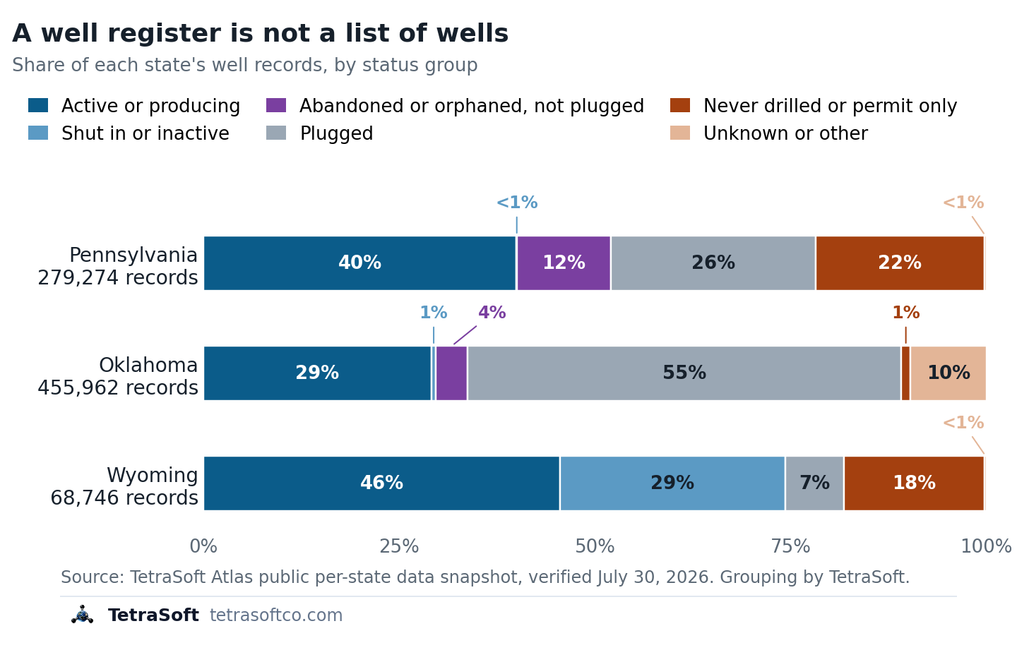
Well records by status group in three states, from the TetraSoft Atlas snapshot of July 30, 2026; Wyoming’s bar covers only the state commission’s Active Wells layer.
Pennsylvania shows the never-drilled effect most sharply, in the red segment of its bar. Its records include 43,698 marked “Operator Reported Not Drilled” and 16,424 marked “Proposed But Never Materialized”, or 60,122 of 279,541 (21.5%) [21]. Another 33,513 Pennsylvania records sit on the Department of Environmental Protection’s abandoned and orphan lists, the purple segment [21].
Of Wyoming’s 130,877 records, 12,358 (9.4%) are permits or cancelled permits [21]. The chart’s Wyoming bar covers only the 68,746-record Active Wells layer of Wyoming’s Oil and Gas Conservation Commission, which leaves out 62,131 plugged wells [21].
Oklahoma shows the second cause, unknown status. Of its 455,962 records, 44,291 (9.7%) fall in the unknown group and 18,490 are marked orphan [1]. A database that drops unknown records reports 9.7% fewer Oklahoma wells than one that keeps them, and neither is wrong [21]. The counter below lets you choose which status groups count as a well and shows how far the total moves.
Want these fields for the wells in your own county, joined on their API numbers? See them in TetraSoft Atlas during a seven-day trial.
Is the Well Still Producing?
Here is how to check if an oil well is producing: read its status, then find the latest month it reported production. Status alone cannot settle it, because an active code can cover a drilled well that sits idle.
In Texas, production reports “are due from operators on the last day of the month for the previous month.” [22] RRC’s Production Data Query FAQ says that leaves “a two-month lag time for online production information.” [22] In Texas, a producing lease’s latest reported month therefore trails the calendar by about two months. A gap of a year or more points toward inactive status, which Texas applies after more than 12 months without reported activity.
What the latest row means depends on how the state reports and how Atlas shows it. In TetraSoft Atlas, the production tab shows recent months for Texas and Colorado. For New Mexico, Pennsylvania, West Virginia, Wyoming and Ohio it shows yearly totals, so the latest entry is a year rather than a month. An Oklahoma well’s production sits with the Tax Commission under its PUN, outside Atlas.
Texas is lease-based too: “production is reported by each oil and gas lease rather than individual well.” [22] Atlas splits each Texas lease total evenly across its wells, so a per-well figure is an estimate, and an idle well can show volumes. A well API number lookup in Atlas works in all eight states, from any state’s well search box.
How TetraSoft Atlas Shows a Well Record
TetraSoft Atlas answers the two problems above: counts that disagree and records split across offices. It opens any well in its eight states as a single record, with that state’s well fields joined on the API number. Its coverage includes Texas and New Mexico, the two largest oil-producing states in 2025 [2]. The walkthrough opens a New Mexico well and steps through its identity, production, gas composition, spill and injection tabs.
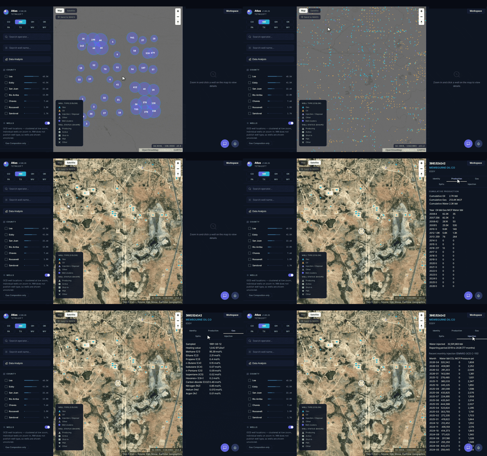
One New Mexico well’s record in TetraSoft Atlas: identity, annual production since 2006, gas composition, spills and injection, joined on its API number.
Each state keeps its regulator’s own status categories rather than a shared national list, so you can see which records a count includes. Start with the wells in your own county and compare the count to the one you use today. Every plan starts with a free 7-day trial, and no credit card is required [3].
Frequently Asked Questions
Is oil and gas well data public?
Yes, most well filings in these eight states are public, though some states keep logs or completion data confidential for a period. Each regulator offers an online search, and most offer bulk downloads. Commercial platforms compile these public filings into one search, often adding their own calculated fields.
How do I look up a well by its API number?
Enter the API number in the search tool of the state that issued it. The first two digits identify the state, so 42 means Texas. Some searches want all 10 digits and others drop the state code, as Texas’s RRC does, so try both if a search finds nothing. A lookup that still fails may point to an unnumbered older well.
How do I find out who operates an oil well?
The operator field on the state’s well record names the operator of record, which may be defunct for an orphaned well. For earlier operators, look for the state’s change-of-operator filings, which in Texas are Form P-4 [4]. The regulator’s operator directory then gives the company’s contact details.
Where can I find a well completion report?
In Texas, completion reports are filed on Form W-2 for oil wells and Form G-1 for gas wells [4]. Both are searchable through the RRC’s online records. Other states file their equivalents with the regulator that issued the permit, such as Colorado’s Form 5 completion report. A completion report records the well’s spud date, drilled total depth and producing interval.
This post is for informational purposes only and does not constitute legal or compliance advice. Consult qualified legal counsel or a compliance professional for guidance specific to your operations and jurisdiction.
References
- TetraSoft Atlas, per-state well counts read 30 September 2026
- U.S. Energy Information Administration, state crude oil and marketed natural gas production tables, annual 2025
- TetraSoft Atlas landing page, read November 3, 2026
- Railroad Commission of Texas, Oil and Gas Forms, accessed September 23, 2026
- Colorado Department of Public Health and Environment, ONGAEIR program page, accessed September 23, 2026
- U.S. Environmental Protection Agency, Subpart W, Petroleum and Natural Gas Systems, page updated May 7, 2026
- 40 CFR 98.238, Definitions, eCFR current text
- 90 FR 44591, September 16, 2025
- Railroad Commission of Texas, Digital Map Information GIS Data FAQ, accessed September 23, 2026
- Professional Petroleum Data Management Association, The US Well Number Standard, 2014
- Railroad Commission of Texas, Data Sets Available for Download, accessed September 22, 2026
- RRC Royalties FAQ (what the Commission cannot advise on), read 2026-09-28
- Oklahoma Tax Commission, Gross Production, accessed September 23, 2026
- Pennsylvania Department of Environmental Protection, Oil and Gas Reports Data Dictionary, version 1.8, April 7, 2022
- Oklahoma Corporation Commission, Well Status Definitions, accessed September 23, 2026
- 055-1 Wyo. Code R. § 1-2, Definitions, Wyoming Oil and Gas Conservation Commission
- 16 Tex. Admin. Code § 3.15, Surface Equipment Removal Requirements and Inactive Wells
- 42 U.S.C. § 15907, Orphaned well site plugging, remediation, and restoration
- 58 Pa.C.S. § 3203, Definitions
- Wyoming Oil and Gas Conservation Commission, Codes and Symbols, accessed September 23, 2026
- TetraSoft calculation from TetraSoft Atlas, per-state well counts read 30 September 2026
- RRC Production Data Query (PDQ) FAQ, how lease production is reported, read 2026-09-28
Interactive tool
How many of these records are wells?
Pick a state, then tick the status groups you count as a well. The total recomputes from the state's real status counts, so you can see how far a well count moves with its definition.
Wells in Pennsylvania
218,704
78.2% of 279,653 records
- Active or producing Active
- 111,757
- Shut in or inactive Regulatory Inactive Status
- 180
- Abandoned or orphaned, not plugged DEP Abandoned List, DEP Orphan List, Abandoned
- 33,464
- Plugged Plugged OG Well, DEP Plugged, Plugged Unverified
- 73,303
- Never drilled or permit only Operator Reported Not Drilled, Proposed But Never Materialized
- 60,128
- Unknown or other Cannot Be Located, Duplicate, Uncharted Mined Through
- 821
TetraSoft Atlas public per-state data snapshot, verified October 28, 2026; grouping by TetraSoft. Status values are kept as each state's records carry them; only the grouping is ours.
Comments
0Share your thoughts. All comments are moderated before appearing.
No comments yet. Be the first to share your thoughts!